

124
Matt Duckham and Mike Worboys
not they are on the mountain. Unlike imprecision and inaccuracy, which may occur
independently in both extensional and intensional aspects of the data, vagueness is
directly associated with the intensional aspects of the data. In other words, we regard vagueness as a type of imperfection in definition, rather than imperfection in
observation (i.e. we adopt an epistemic view of vagueness, leaving to one side for
the moment debates about ontic vagueness [39]).
Although vagueness is an intensional phenomenon, vagueness can have an extensional expression in spatial data sets, which typically impose precise spatial boundaries around spatial regions. If, as is often the case in spatial data, the underlying
categories are vague (such as the categories “Mountain” or “Forest” [4, 24]) then the
actual boundaries imposed will be somewhat arbitrary. The effect of such boundary
arbitrariness on a rosetta system will be similar to those resulting from inaccuracy:
it will degrade the reliability of the inductive inference process, potentially leading
to errors of omission and commission in identifying semantic relationships between
categories represented in the source data sets.
In order to tackle vagueness, it is first necessary to provide an explicit representation of the existence of vagueness. Typically, this is done by replacing the crisp
boundaries for regions used in conventional spatial data with a representation of
regions with broad boundaries, such as fuzzy sets [23], rough sets [21], two-stage
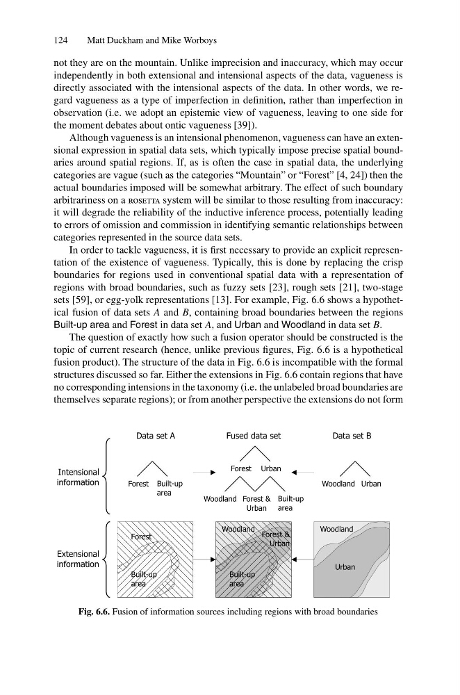
sets [59], or egg-yolk representations [13]. For example, Fig. 6.6 shows a hypothetical fusion of data sets A and B, containing broad boundaries between the regions
Built-up area and Forest in data set A, and Urban and Woodland in data set B.
The question of exactly how such a fusion operator should be constructed is the
topic of current research (hence, unlike previous figures, Fig. 6.6 is a hypothetical
fusion product). The structure of the data in Fig. 6.6 is incompatible with the formal
structures discussed so far. Either the extensions in Fig. 6.6 contain regions that have
no corresponding intensions in the taxonomy (i.e. the unlabeled broad boundaries are
themselves separate regions); or from another perspective the extensions do not form
Built-up
area
Forest
Woodland
Urban
Woodland Urban
Intensional
information
Extensional
information
Forest Built-up
area
Forest Urban
Woodland Forest &
Urban
Built-up
area
Built-up
area
Forest &
Urban
Woodland
Data set A
Data set B
Fused data set
Fig. 6.6. Fusion of information sources including regions with broad boundaries
Matt Duckham and Mike Worboys
not they are on the mountain. Unlike imprecision and inaccuracy, which may occur
independently in both extensional and intensional aspects of the data, vagueness is
directly associated with the intensional aspects of the data. In other words, we regard vagueness as a type of imperfection in definition, rather than imperfection in
observation (i.e. we adopt an epistemic view of vagueness, leaving to one side for
the moment debates about ontic vagueness [39]).
Although vagueness is an intensional phenomenon, vagueness can have an extensional expression in spatial data sets, which typically impose precise spatial boundaries around spatial regions. If, as is often the case in spatial data, the underlying
categories are vague (such as the categories “Mountain” or “Forest” [4, 24]) then the
actual boundaries imposed will be somewhat arbitrary. The effect of such boundary
arbitrariness on a rosetta system will be similar to those resulting from inaccuracy:
it will degrade the reliability of the inductive inference process, potentially leading
to errors of omission and commission in identifying semantic relationships between
categories represented in the source data sets.
In order to tackle vagueness, it is first necessary to provide an explicit representation of the existence of vagueness. Typically, this is done by replacing the crisp
boundaries for regions used in conventional spatial data with a representation of
regions with broad boundaries, such as fuzzy sets [23], rough sets [21], two-stage
sets [59], or egg-yolk representations [13]. For example, Fig. 6.6 shows a hypothetical fusion of data sets A and B, containing broad boundaries between the regions
Built-up area and Forest in data set A, and Urban and Woodland in data set B.
The question of exactly how such a fusion operator should be constructed is the
topic of current research (hence, unlike previous figures, Fig. 6.6 is a hypothetical
fusion product). The structure of the data in Fig. 6.6 is incompatible with the formal
structures discussed so far. Either the extensions in Fig. 6.6 contain regions that have
no corresponding intensions in the taxonomy (i.e. the unlabeled broad boundaries are
themselves separate regions); or from another perspective the extensions do not form
Built-up
area
Forest
Woodland
Urban
Woodland Urban
Intensional
information
Extensional
information
Forest Built-up
area
Forest Urban
Woodland Forest &
Urban
Built-up
area
Built-up
area
Forest &
Urban
Woodland
Data set A
Data set B
Fused data set
Fig. 6.6. Fusion of information sources including regions with broad boundaries