

6 Automated Geographical Information Fusion
123
Intensional
information
Extensional
information
Woodland Urban
Forest Built-up
area
Forest Urban
Woodland
Built-up
area
Data set A
Data set B
Fused data set
F W
?
B U
?
F U
?
B W
?
Built-up
area
Forest
Woodland
Urban
Woodland
Built-up
area
Woodland
Forest &
Urban
Woodland
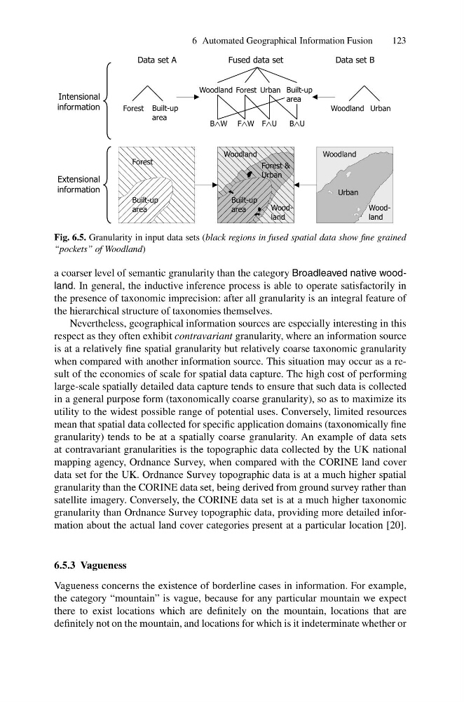
Fig. 6.5. Granularity in input data sets (black regions in fused spatial data show fine grained
“pockets” of Woodland)
a coarser level of semantic granularity than the category Broadleaved native woodland. In general, the inductive inference process is able to operate satisfactorily in
the presence of taxonomic imprecision: after all granularity is an integral feature of
the hierarchical structure of taxonomies themselves.
Nevertheless, geographical information sources are especially interesting in this
respect as they often exhibit contravariant granularity, where an information source
is at a relatively fine spatial granularity but relatively coarse taxonomic granularity
when compared with another information source. This situation may occur as a result of the economies of scale for spatial data capture. The high cost of performing
large-scale spatially detailed data capture tends to ensure that such data is collected
in a general purpose form (taxonomically coarse granularity), so as to maximize its
utility to the widest possible range of potential uses. Conversely, limited resources
mean that spatial data collected for specific application domains (taxonomically fine
granularity) tends to be at a spatially coarse granularity. An example of data sets
at contravariant granularities is the topographic data collected by the UK national
mapping agency, Ordnance Survey, when compared with the CORINE land cover
data set for the UK. Ordnance Survey topographic data is at a much higher spatial
granularity than the CORINE data set, being derived from ground survey rather than
satellite imagery. Conversely, the CORINE data set is at a much higher taxonomic
granularity than Ordnance Survey topographic data, providing more detailed information about the actual land cover categories present at a particular location [20].
6.5.3 Vagueness
Vagueness concerns the existence of borderline cases in information. For example,
the category “mountain” is vague, because for any particular mountain we expect
there to exist locations which are definitely on the mountain, locations that are
definitely not on the mountain, and locations for which is it indeterminate whether or
123
Intensional
information
Extensional
information
Woodland Urban
Forest Built-up
area
Forest Urban
Woodland
Built-up
area
Data set A
Data set B
Fused data set
F W
?
B U
?
F U
?
B W
?
Built-up
area
Forest
Woodland
Urban
Woodland
Built-up
area
Woodland
Forest &
Urban
Woodland
Fig. 6.5. Granularity in input data sets (black regions in fused spatial data show fine grained
“pockets” of Woodland)
a coarser level of semantic granularity than the category Broadleaved native woodland. In general, the inductive inference process is able to operate satisfactorily in
the presence of taxonomic imprecision: after all granularity is an integral feature of
the hierarchical structure of taxonomies themselves.
Nevertheless, geographical information sources are especially interesting in this
respect as they often exhibit contravariant granularity, where an information source
is at a relatively fine spatial granularity but relatively coarse taxonomic granularity
when compared with another information source. This situation may occur as a result of the economies of scale for spatial data capture. The high cost of performing
large-scale spatially detailed data capture tends to ensure that such data is collected
in a general purpose form (taxonomically coarse granularity), so as to maximize its
utility to the widest possible range of potential uses. Conversely, limited resources
mean that spatial data collected for specific application domains (taxonomically fine
granularity) tends to be at a spatially coarse granularity. An example of data sets
at contravariant granularities is the topographic data collected by the UK national
mapping agency, Ordnance Survey, when compared with the CORINE land cover
data set for the UK. Ordnance Survey topographic data is at a much higher spatial
granularity than the CORINE data set, being derived from ground survey rather than
satellite imagery. Conversely, the CORINE data set is at a much higher taxonomic
granularity than Ordnance Survey topographic data, providing more detailed information about the actual land cover categories present at a particular location [20].
6.5.3 Vagueness
Vagueness concerns the existence of borderline cases in information. For example,
the category “mountain” is vague, because for any particular mountain we expect
there to exist locations which are definitely on the mountain, locations that are
definitely not on the mountain, and locations for which is it indeterminate whether or