

6 Automated Geographical Information Fusion
121
6.5 Uncertainty
Geographical information is inherently imperfect, leading to uncertainty about the
real features represented in a geographical data set. Imperfection is often represented
and quantified using spatial data quality elements and standards (Chap. 7). However,
there are many different spatial data quality elements that have been proposed in
standards and the research literature. Three fundamental types of imperfection are
commonly identified in the literature: inaccuracy, imprecision, and vagueness [21,
70, 72]. In this section we look at the effects of each of these types of imperfection in
turn, followed by an overview of ongoing research into ways to regulate uncertainty
in a rosetta system.
6.5.1 Inaccuracy
Inaccuracy in geographical information concerns a lack of correspondence between
information and the actual state of affairs in the physical world. In a rosetta system, inaccuracy degrades the reliability of the inductive inference process, potentially leading to semantic relationships being inferred between categories that are, in
reality, unrelated. Conversely, inaccuracy may lead to a failure to identify semantic
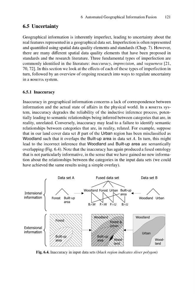
relationships between categories that are, in reality, related. For example, suppose
that in our land cover data set B part of the Urban region has been misclassified as
Woodland such that it overlaps the Built-up area in data set A. In turn, this might
lead to the incorrect inference that Woodland and Built-up area are semantically
overlapping (Fig. 6.4). Note that the inaccuracy has again produced a fused ontology
that is not particularly informative, in the sense that we have gained no new information about the relationships between the categories in the input data sets (we could
have achieved the same results using a simple overlay).
Built-up
area
Forest
Woodland
Urban
Intensional
information
Extensional
information
Woodland
Built-up
area
Woodland
Forest &
Urban
Woodland
Woodland Urban
Forest Built-up
area
Forest Urban
Woodland
Built-up
area
Data set A
Data set B
Fused data set
F W
?
B U
?
F U
?
B W
?
Fig. 6.4. Inaccuracy in input data sets (black region indicates sliver polygon)
121
6.5 Uncertainty
Geographical information is inherently imperfect, leading to uncertainty about the
real features represented in a geographical data set. Imperfection is often represented
and quantified using spatial data quality elements and standards (Chap. 7). However,
there are many different spatial data quality elements that have been proposed in
standards and the research literature. Three fundamental types of imperfection are
commonly identified in the literature: inaccuracy, imprecision, and vagueness [21,
70, 72]. In this section we look at the effects of each of these types of imperfection in
turn, followed by an overview of ongoing research into ways to regulate uncertainty
in a rosetta system.
6.5.1 Inaccuracy
Inaccuracy in geographical information concerns a lack of correspondence between
information and the actual state of affairs in the physical world. In a rosetta system, inaccuracy degrades the reliability of the inductive inference process, potentially leading to semantic relationships being inferred between categories that are, in
reality, unrelated. Conversely, inaccuracy may lead to a failure to identify semantic
relationships between categories that are, in reality, related. For example, suppose
that in our land cover data set B part of the Urban region has been misclassified as
Woodland such that it overlaps the Built-up area in data set A. In turn, this might
lead to the incorrect inference that Woodland and Built-up area are semantically
overlapping (Fig. 6.4). Note that the inaccuracy has again produced a fused ontology
that is not particularly informative, in the sense that we have gained no new information about the relationships between the categories in the input data sets (we could
have achieved the same results using a simple overlay).
Built-up
area
Forest
Woodland
Urban
Intensional
information
Extensional
information
Woodland
Built-up
area
Woodland
Forest &
Urban
Woodland
Woodland Urban
Forest Built-up
area
Forest Urban
Woodland
Built-up
area
Data set A
Data set B
Fused data set
F W
?
B U
?
F U
?
B W
?
Fig. 6.4. Inaccuracy in input data sets (black region indicates sliver polygon)