

6 Automated Geographical Information Fusion
119
Forest
Woodland
Woodland Urban
Intensional
information
Extensional
information
Forest Built-up
area
Forest Urban
Woodland
Built-up
area
Data set A
Data set B
Fused data set
Built-up
area
Urban
B W
?
B U
?
F W
?
F U
?
F W
?
B U
?
F U
?
B W
?
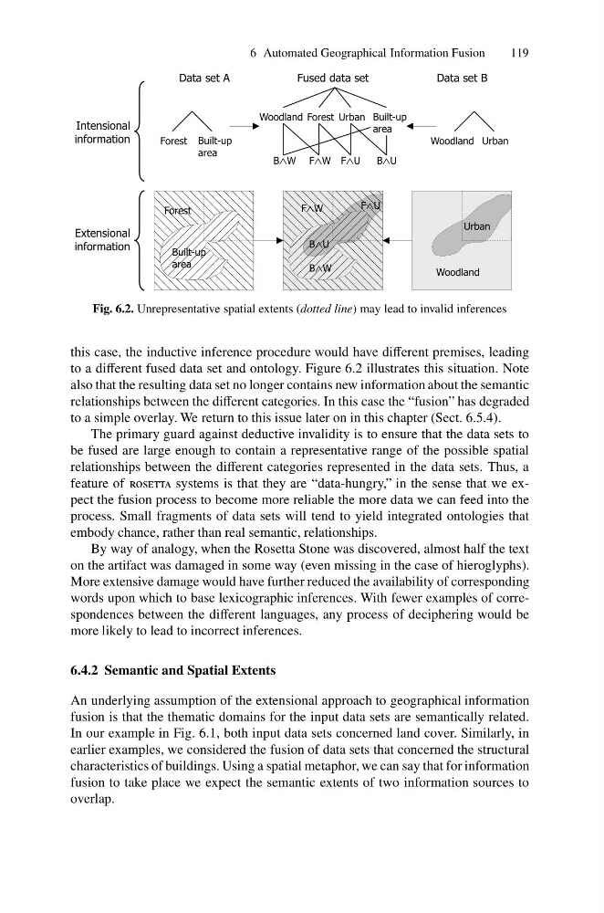
Fig. 6.2. Unrepresentative spatial extents (dotted line) may lead to invalid inferences
this case, the inductive inference procedure would have different premises, leading
to a different fused data set and ontology. Figure 6.2 illustrates this situation. Note
also that the resulting data set no longer contains new information about the semantic
relationships between the different categories. In this case the “fusion” has degraded
to a simple overlay. We return to this issue later on in this chapter (Sect. 6.5.4).
The primary guard against deductive invalidity is to ensure that the data sets to
be fused are large enough to contain a representative range of the possible spatial
relationships between the different categories represented in the data sets. Thus, a
feature of rosetta systems is that they are “data-hungry,” in the sense that we expect the fusion process to become more reliable the more data we can feed into the
process. Small fragments of data sets will tend to yield integrated ontologies that
embody chance, rather than real semantic, relationships.
By way of analogy, when the Rosetta Stone was discovered, almost half the text
on the artifact was damaged in some way (even missing in the case of hieroglyphs).
More extensive damage would have further reduced the availability of corresponding
words upon which to base lexicographic inferences. With fewer examples of correspondences between the different languages, any process of deciphering would be
more likely to lead to incorrect inferences.
6.4.2 Semantic and Spatial Extents
An underlying assumption of the extensional approach to geographical information
fusion is that the thematic domains for the input data sets are semantically related.
In our example in Fig. 6.1, both input data sets concerned land cover. Similarly, in
earlier examples, we considered the fusion of data sets that concerned the structural
characteristics of buildings. Using a spatial metaphor, we can say that for information
fusion to take place we expect the semantic extents of two information sources to
overlap.
119
Forest
Woodland
Woodland Urban
Intensional
information
Extensional
information
Forest Built-up
area
Forest Urban
Woodland
Built-up
area
Data set A
Data set B
Fused data set
Built-up
area
Urban
B W
?
B U
?
F W
?
F U
?
F W
?
B U
?
F U
?
B W
?
Fig. 6.2. Unrepresentative spatial extents (dotted line) may lead to invalid inferences
this case, the inductive inference procedure would have different premises, leading
to a different fused data set and ontology. Figure 6.2 illustrates this situation. Note
also that the resulting data set no longer contains new information about the semantic
relationships between the different categories. In this case the “fusion” has degraded
to a simple overlay. We return to this issue later on in this chapter (Sect. 6.5.4).
The primary guard against deductive invalidity is to ensure that the data sets to
be fused are large enough to contain a representative range of the possible spatial
relationships between the different categories represented in the data sets. Thus, a
feature of rosetta systems is that they are “data-hungry,” in the sense that we expect the fusion process to become more reliable the more data we can feed into the
process. Small fragments of data sets will tend to yield integrated ontologies that
embody chance, rather than real semantic, relationships.
By way of analogy, when the Rosetta Stone was discovered, almost half the text
on the artifact was damaged in some way (even missing in the case of hieroglyphs).
More extensive damage would have further reduced the availability of corresponding
words upon which to base lexicographic inferences. With fewer examples of correspondences between the different languages, any process of deciphering would be
more likely to lead to incorrect inferences.
6.4.2 Semantic and Spatial Extents
An underlying assumption of the extensional approach to geographical information
fusion is that the thematic domains for the input data sets are semantically related.
In our example in Fig. 6.1, both input data sets concerned land cover. Similarly, in
earlier examples, we considered the fusion of data sets that concerned the structural
characteristics of buildings. Using a spatial metaphor, we can say that for information
fusion to take place we expect the semantic extents of two information sources to
overlap.