

18 Eddies in the Red Sea as seen by Satellite SAR Imagery
361
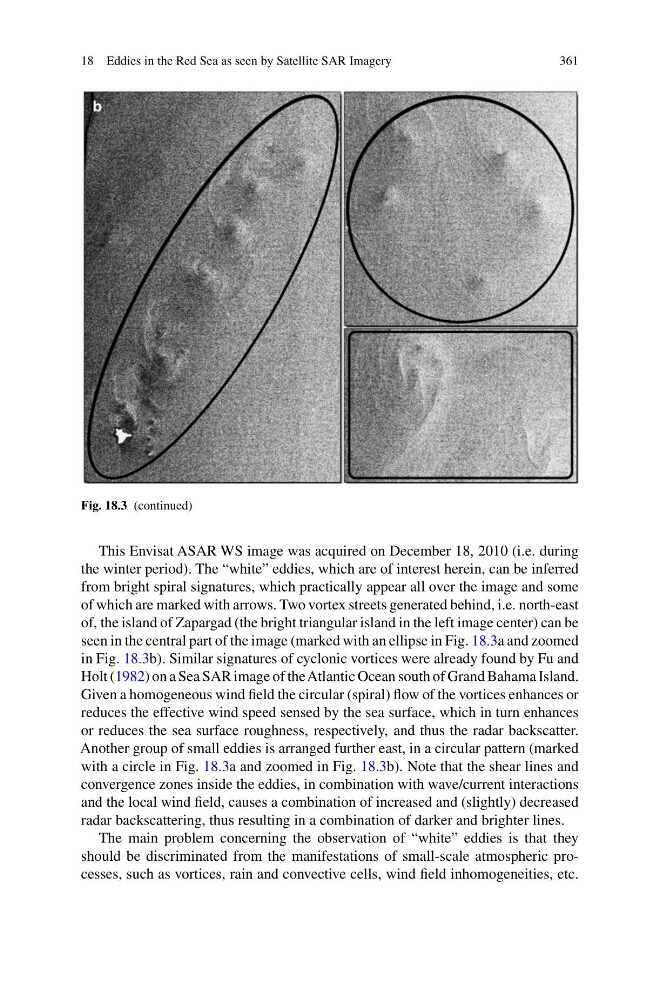
Fig. 18.3 (continued)
This Envisat ASAR WS image was acquired on December 18, 2010 (i.e. during
the winter period). The “white” eddies, which are of interest herein, can be inferred
from bright spiral signatures, which practically appear all over the image and some
of which are marked with arrows. Two vortex streets generated behind, i.e. north-east
of, the island of Zapargad (the bright triangular island in the left image center) can be
seen in the central part of the image (marked with an ellipse in Fig. 18.3a and zoomed
in Fig. 18.3b). Similar signatures of cyclonic vortices were already found by Fu and
Holt (1982) on a Sea SAR image of the Atlantic Ocean south of Grand Bahama Island.
Given a homogeneous wind field the circular (spiral) flow of the vortices enhances or
reduces the effective wind speed sensed by the sea surface, which in turn enhances
or reduces the sea surface roughness, respectively, and thus the radar backscatter.
Another group of small eddies is arranged further east, in a circular pattern (marked
with a circle in Fig. 18.3a and zoomed in Fig. 18.3b). Note that the shear lines and
convergence zones inside the eddies, in combination with wave/current interactions
and the local wind field, causes a combination of increased and (slightly) decreased
radar backscattering, thus resulting in a combination of darker and brighter lines.
The main problem concerning the observation of “white” eddies is that they
should be discriminated from the manifestations of small-scale atmospheric processes, such as vortices, rain and convective cells, wind field inhomogeneities, etc.
361
Fig. 18.3 (continued)
This Envisat ASAR WS image was acquired on December 18, 2010 (i.e. during
the winter period). The “white” eddies, which are of interest herein, can be inferred
from bright spiral signatures, which practically appear all over the image and some
of which are marked with arrows. Two vortex streets generated behind, i.e. north-east
of, the island of Zapargad (the bright triangular island in the left image center) can be
seen in the central part of the image (marked with an ellipse in Fig. 18.3a and zoomed
in Fig. 18.3b). Similar signatures of cyclonic vortices were already found by Fu and
Holt (1982) on a Sea SAR image of the Atlantic Ocean south of Grand Bahama Island.
Given a homogeneous wind field the circular (spiral) flow of the vortices enhances or
reduces the effective wind speed sensed by the sea surface, which in turn enhances
or reduces the sea surface roughness, respectively, and thus the radar backscatter.
Another group of small eddies is arranged further east, in a circular pattern (marked
with a circle in Fig. 18.3a and zoomed in Fig. 18.3b). Note that the shear lines and
convergence zones inside the eddies, in combination with wave/current interactions
and the local wind field, causes a combination of increased and (slightly) decreased
radar backscattering, thus resulting in a combination of darker and brighter lines.
The main problem concerning the observation of “white” eddies is that they
should be discriminated from the manifestations of small-scale atmospheric processes, such as vortices, rain and convective cells, wind field inhomogeneities, etc.