

16 Remote Sensing of Coral Reefs and Their Environments . . .
327
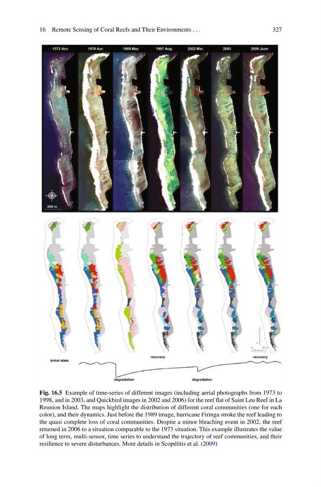
Fig. 16.5 Example of time-series of different images (including aerial photographs from 1973 to
1998, and in 2003, and Quickbird images in 2002 and 2006) for the reef flat of Saint Leu Reef in La
Reunion Island. The maps highlight the distribution of different coral communities (one for each
color), and their dynamics. Just before the 1989 image, hurricane Firinga stroke the reef leading to
the quasi complete loss of coral communities. Despite a minor bleaching event in 2002, the reef
returned in 2006 to a situation comparable to the 1973 situation. This example illustrates the value
of long term, multi-sensor, time series to understand the trajectory of reef communities, and their
resilience to severe disturbances. More details in Scopélitis et al. (2009)
327
Fig. 16.5 Example of time-series of different images (including aerial photographs from 1973 to
1998, and in 2003, and Quickbird images in 2002 and 2006) for the reef flat of Saint Leu Reef in La
Reunion Island. The maps highlight the distribution of different coral communities (one for each
color), and their dynamics. Just before the 1989 image, hurricane Firinga stroke the reef leading to
the quasi complete loss of coral communities. Despite a minor bleaching event in 2002, the reef
returned in 2006 to a situation comparable to the 1973 situation. This example illustrates the value
of long term, multi-sensor, time series to understand the trajectory of reef communities, and their
resilience to severe disturbances. More details in Scopélitis et al. (2009)