

16 Remote Sensing of Coral Reefs and Their Environments . . .
321
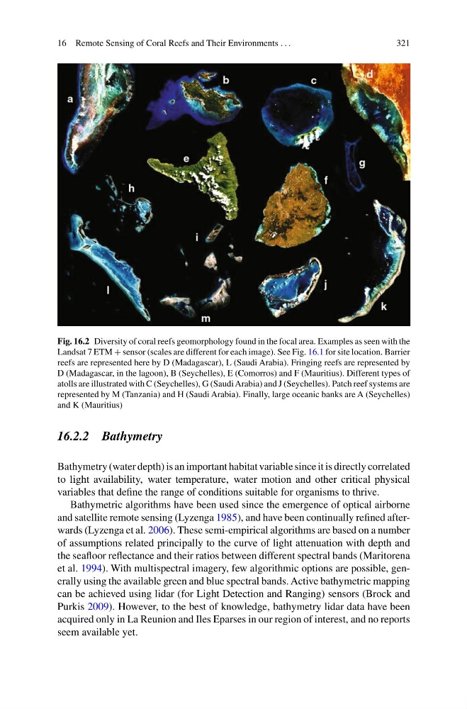
Fig. 16.2 Diversity of coral reefs geomorphology found in the focal area. Examples as seen with the
Landsat 7 ETM + sensor (scales are different for each image). See Fig. 16.1 for site location. Barrier
reefs are represented here by D (Madagascar), L (Saudi Arabia). Fringing reefs are represented by
D (Madagascar, in the lagoon), B (Seychelles), E (Comorros) and F (Mauritius). Different types of
atolls are illustrated with C (Seychelles), G (Saudi Arabia) and J (Seychelles). Patch reef systems are
represented by M (Tanzania) and H (Saudi Arabia). Finally, large oceanic banks are A (Seychelles)
and K (Mauritius)
16.2.2 Bathymetry
Bathymetry (water depth) is an important habitat variable since it is directly correlated
to light availability, water temperature, water motion and other critical physical
variables that define the range of conditions suitable for organisms to thrive.
Bathymetric algorithms have been used since the emergence of optical airborne
and satellite remote sensing (Lyzenga 1985), and have been continually refined afterwards (Lyzenga et al. 2006). These semi-empirical algorithms are based on a number
of assumptions related principally to the curve of light attenuation with depth and
the seafloor reflectance and their ratios between different spectral bands (Maritorena
et al. 1994). With multispectral imagery, few algorithmic options are possible, generally using the available green and blue spectral bands. Active bathymetric mapping
can be achieved using lidar (for Light Detection and Ranging) sensors (Brock and
Purkis 2009). However, to the best of knowledge, bathymetry lidar data have been
acquired only in La Reunion and Iles Eparses in our region of interest, and no reports
seem available yet.
321
Fig. 16.2 Diversity of coral reefs geomorphology found in the focal area. Examples as seen with the
Landsat 7 ETM + sensor (scales are different for each image). See Fig. 16.1 for site location. Barrier
reefs are represented here by D (Madagascar), L (Saudi Arabia). Fringing reefs are represented by
D (Madagascar, in the lagoon), B (Seychelles), E (Comorros) and F (Mauritius). Different types of
atolls are illustrated with C (Seychelles), G (Saudi Arabia) and J (Seychelles). Patch reef systems are
represented by M (Tanzania) and H (Saudi Arabia). Finally, large oceanic banks are A (Seychelles)
and K (Mauritius)
16.2.2 Bathymetry
Bathymetry (water depth) is an important habitat variable since it is directly correlated
to light availability, water temperature, water motion and other critical physical
variables that define the range of conditions suitable for organisms to thrive.
Bathymetric algorithms have been used since the emergence of optical airborne
and satellite remote sensing (Lyzenga 1985), and have been continually refined afterwards (Lyzenga et al. 2006). These semi-empirical algorithms are based on a number
of assumptions related principally to the curve of light attenuation with depth and
the seafloor reflectance and their ratios between different spectral bands (Maritorena
et al. 1994). With multispectral imagery, few algorithmic options are possible, generally using the available green and blue spectral bands. Active bathymetric mapping
can be achieved using lidar (for Light Detection and Ranging) sensors (Brock and
Purkis 2009). However, to the best of knowledge, bathymetry lidar data have been
acquired only in La Reunion and Iles Eparses in our region of interest, and no reports
seem available yet.