

15 Ship Surveillance with High Resolution TerraSAR-X Satellite in African Waters
311
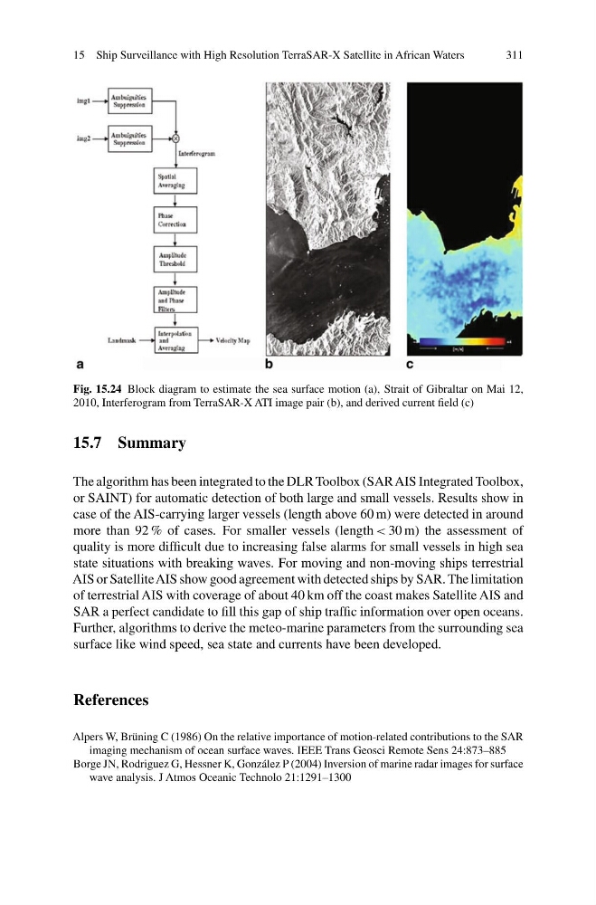
Fig. 15.24 Block diagram to estimate the sea surface motion (a), Strait of Gibraltar on Mai 12,
2010, Interferogram from TerraSAR-X ATI image pair (b), and derived current field (c)
15.7 Summary
The algorithm has been integrated to the DLR Toolbox (SAR AIS Integrated Toolbox,
or SAINT) for automatic detection of both large and small vessels. Results show in
case of the AIS-carrying larger vessels (length above 60 m) were detected in around
more than 92 % of cases. For smaller vessels (length < 30 m) the assessment of
quality is more difficult due to increasing false alarms for small vessels in high sea
state situations with breaking waves. For moving and non-moving ships terrestrial
AIS or Satellite AIS show good agreement with detected ships by SAR. The limitation
of terrestrial AIS with coverage of about 40 km off the coast makes Satellite AIS and
SAR a perfect candidate to fill this gap of ship traffic information over open oceans.
Further, algorithms to derive the meteo-marine parameters from the surrounding sea
surface like wind speed, sea state and currents have been developed.
References
Alpers W, Brüning C (1986) On the relative importance of motion-related contributions to the SAR
imaging mechanism of ocean surface waves. IEEE Trans Geosci Remote Sens 24:873–885
Borge JN, Rodriguez G, Hessner K, González P (2004) Inversion of marine radar images for surface
wave analysis. J Atmos Oceanic Technolo 21:1291–1300
311
Fig. 15.24 Block diagram to estimate the sea surface motion (a), Strait of Gibraltar on Mai 12,
2010, Interferogram from TerraSAR-X ATI image pair (b), and derived current field (c)
15.7 Summary
The algorithm has been integrated to the DLR Toolbox (SAR AIS Integrated Toolbox,
or SAINT) for automatic detection of both large and small vessels. Results show in
case of the AIS-carrying larger vessels (length above 60 m) were detected in around
more than 92 % of cases. For smaller vessels (length < 30 m) the assessment of
quality is more difficult due to increasing false alarms for small vessels in high sea
state situations with breaking waves. For moving and non-moving ships terrestrial
AIS or Satellite AIS show good agreement with detected ships by SAR. The limitation
of terrestrial AIS with coverage of about 40 km off the coast makes Satellite AIS and
SAR a perfect candidate to fill this gap of ship traffic information over open oceans.
Further, algorithms to derive the meteo-marine parameters from the surrounding sea
surface like wind speed, sea state and currents have been developed.
References
Alpers W, Brüning C (1986) On the relative importance of motion-related contributions to the SAR
imaging mechanism of ocean surface waves. IEEE Trans Geosci Remote Sens 24:873–885
Borge JN, Rodriguez G, Hessner K, González P (2004) Inversion of marine radar images for surface
wave analysis. J Atmos Oceanic Technolo 21:1291–1300