

15 Ship Surveillance with High Resolution TerraSAR-X Satellite in African Waters
293
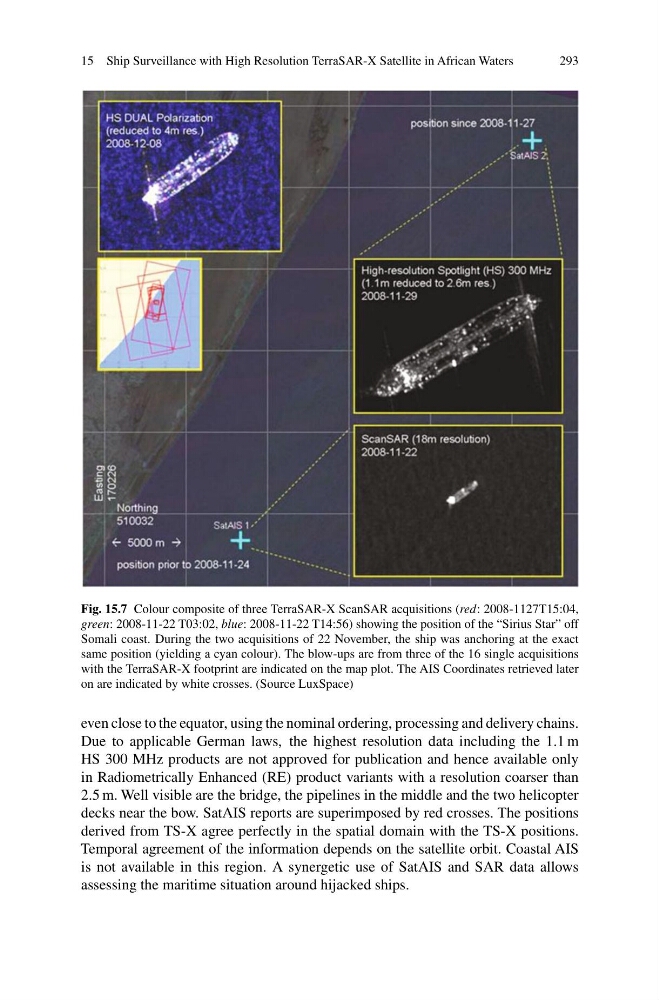
Fig. 15.7 Colour composite of three TerraSAR-X ScanSAR acquisitions (red: 2008-1127T15:04,
green: 2008-11-22 T03:02, blue: 2008-11-22 T14:56) showing the position of the “Sirius Star” off
Somali coast. During the two acquisitions of 22 November, the ship was anchoring at the exact
same position (yielding a cyan colour). The blow-ups are from three of the 16 single acquisitions
with the TerraSAR-X footprint are indicated on the map plot. The AIS Coordinates retrieved later
on are indicated by white crosses. (Source LuxSpace)
even close to the equator, using the nominal ordering, processing and delivery chains.
Due to applicable German laws, the highest resolution data including the 1.1 m
HS 300 MHz products are not approved for publication and hence available only
in Radiometrically Enhanced (RE) product variants with a resolution coarser than
2.5 m. Well visible are the bridge, the pipelines in the middle and the two helicopter
decks near the bow. SatAIS reports are superimposed by red crosses. The positions
derived from TS-X agree perfectly in the spatial domain with the TS-X positions.
Temporal agreement of the information depends on the satellite orbit. Coastal AIS
is not available in this region. A synergetic use of SatAIS and SAR data allows
assessing the maritime situation around hijacked ships.
293
Fig. 15.7 Colour composite of three TerraSAR-X ScanSAR acquisitions (red: 2008-1127T15:04,
green: 2008-11-22 T03:02, blue: 2008-11-22 T14:56) showing the position of the “Sirius Star” off
Somali coast. During the two acquisitions of 22 November, the ship was anchoring at the exact
same position (yielding a cyan colour). The blow-ups are from three of the 16 single acquisitions
with the TerraSAR-X footprint are indicated on the map plot. The AIS Coordinates retrieved later
on are indicated by white crosses. (Source LuxSpace)
even close to the equator, using the nominal ordering, processing and delivery chains.
Due to applicable German laws, the highest resolution data including the 1.1 m
HS 300 MHz products are not approved for publication and hence available only
in Radiometrically Enhanced (RE) product variants with a resolution coarser than
2.5 m. Well visible are the bridge, the pipelines in the middle and the two helicopter
decks near the bow. SatAIS reports are superimposed by red crosses. The positions
derived from TS-X agree perfectly in the spatial domain with the TS-X positions.
Temporal agreement of the information depends on the satellite orbit. Coastal AIS
is not available in this region. A synergetic use of SatAIS and SAR data allows
assessing the maritime situation around hijacked ships.