

12 Observing the Agulhas Current With Sea Surface Temperature . . .
241
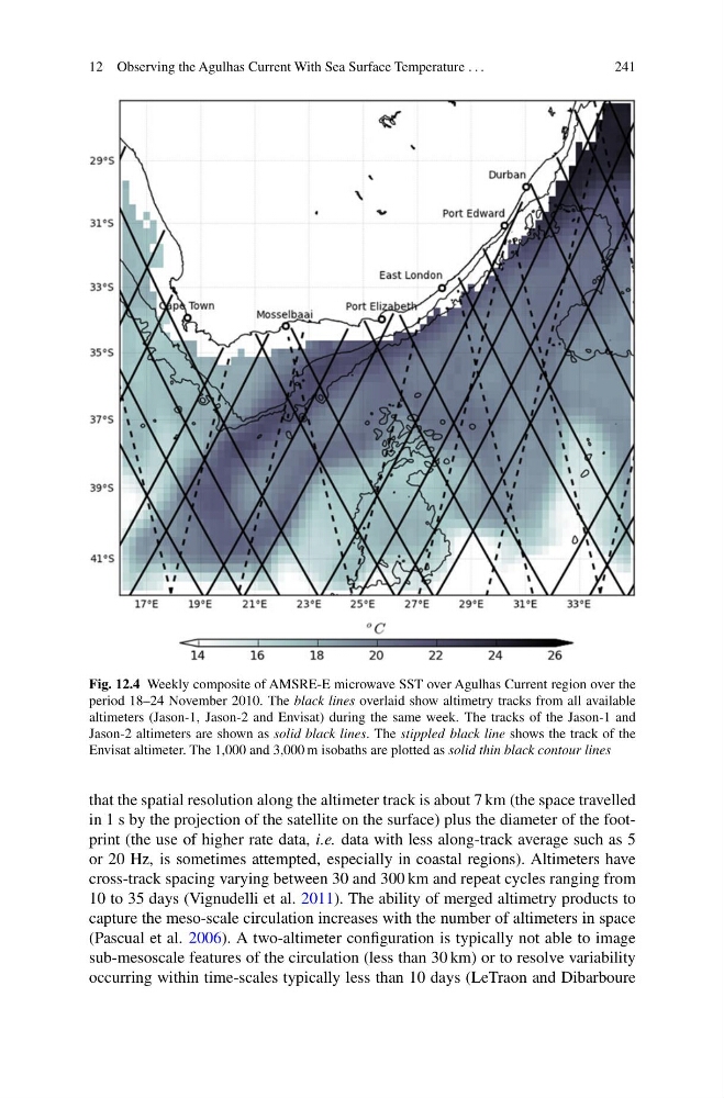
Fig. 12.4 Weekly composite of AMSRE-E microwave SST over Agulhas Current region over the
period 18–24 November 2010. The black lines overlaid show altimetry tracks from all available
altimeters (Jason-1, Jason-2 and Envisat) during the same week. The tracks of the Jason-1 and
Jason-2 altimeters are shown as solid black lines. The stippled black line shows the track of the
Envisat altimeter. The 1,000 and 3,000 m isobaths are plotted as solid thin black contour lines
that the spatial resolution along the altimeter track is about 7 km (the space travelled
in 1 s by the projection of the satellite on the surface) plus the diameter of the footprint (the use of higher rate data, i.e. data with less along-track average such as 5
or 20 Hz, is sometimes attempted, especially in coastal regions). Altimeters have
cross-track spacing varying between 30 and 300 km and repeat cycles ranging from
10 to 35 days (Vignudelli et al. 2011). The ability of merged altimetry products to
capture the meso-scale circulation increases with the number of altimeters in space
(Pascual et al. 2006). A two-altimeter configuration is typically not able to image
sub-mesoscale features of the circulation (less than 30 km) or to resolve variability
occurring within time-scales typically less than 10 days (LeTraon and Dibarboure
241
Fig. 12.4 Weekly composite of AMSRE-E microwave SST over Agulhas Current region over the
period 18–24 November 2010. The black lines overlaid show altimetry tracks from all available
altimeters (Jason-1, Jason-2 and Envisat) during the same week. The tracks of the Jason-1 and
Jason-2 altimeters are shown as solid black lines. The stippled black line shows the track of the
Envisat altimeter. The 1,000 and 3,000 m isobaths are plotted as solid thin black contour lines
that the spatial resolution along the altimeter track is about 7 km (the space travelled
in 1 s by the projection of the satellite on the surface) plus the diameter of the footprint (the use of higher rate data, i.e. data with less along-track average such as 5
or 20 Hz, is sometimes attempted, especially in coastal regions). Altimeters have
cross-track spacing varying between 30 and 300 km and repeat cycles ranging from
10 to 35 days (Vignudelli et al. 2011). The ability of merged altimetry products to
capture the meso-scale circulation increases with the number of altimeters in space
(Pascual et al. 2006). A two-altimeter configuration is typically not able to image
sub-mesoscale features of the circulation (less than 30 km) or to resolve variability
occurring within time-scales typically less than 10 days (LeTraon and Dibarboure