

226
W. Alpers et al.
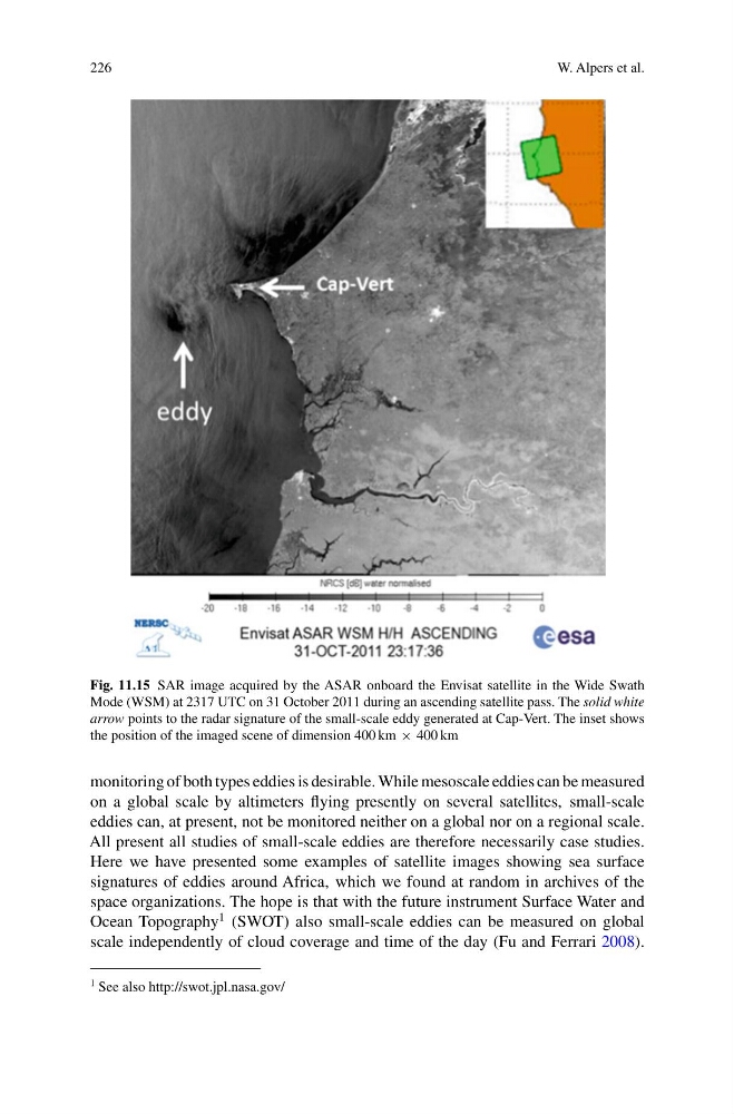
Fig. 11.15 SAR image acquired by the ASAR onboard the Envisat satellite in the Wide Swath
Mode (WSM) at 2317 UTC on 31 October 2011 during an ascending satellite pass. The solid white
arrow points to the radar signature of the small-scale eddy generated at Cap-Vert. The inset shows
the position of the imaged scene of dimension 400 km × 400 km
monitoring of both types eddies is desirable. While mesoscale eddies can be measured
on a global scale by altimeters flying presently on several satellites, small-scale
eddies can, at present, not be monitored neither on a global nor on a regional scale.
All present all studies of small-scale eddies are therefore necessarily case studies.
Here we have presented some examples of satellite images showing sea surface
signatures of eddies around Africa, which we found at random in archives of the
space organizations. The hope is that with the future instrument Surface Water and
Ocean Topography
1 (SWOT) also small-scale eddies can be measured on global
scale independently of cloud coverage and time of the day (Fu and Ferrari 2008).
1 See also http://swot.jpl.nasa.gov/
W. Alpers et al.
Fig. 11.15 SAR image acquired by the ASAR onboard the Envisat satellite in the Wide Swath
Mode (WSM) at 2317 UTC on 31 October 2011 during an ascending satellite pass. The solid white
arrow points to the radar signature of the small-scale eddy generated at Cap-Vert. The inset shows
the position of the imaged scene of dimension 400 km × 400 km
monitoring of both types eddies is desirable. While mesoscale eddies can be measured
on a global scale by altimeters flying presently on several satellites, small-scale
eddies can, at present, not be monitored neither on a global nor on a regional scale.
All present all studies of small-scale eddies are therefore necessarily case studies.
Here we have presented some examples of satellite images showing sea surface
signatures of eddies around Africa, which we found at random in archives of the
space organizations. The hope is that with the future instrument Surface Water and
Ocean Topography
1 (SWOT) also small-scale eddies can be measured on global
scale independently of cloud coverage and time of the day (Fu and Ferrari 2008).
1 See also http://swot.jpl.nasa.gov/