

214
W. Alpers et al.
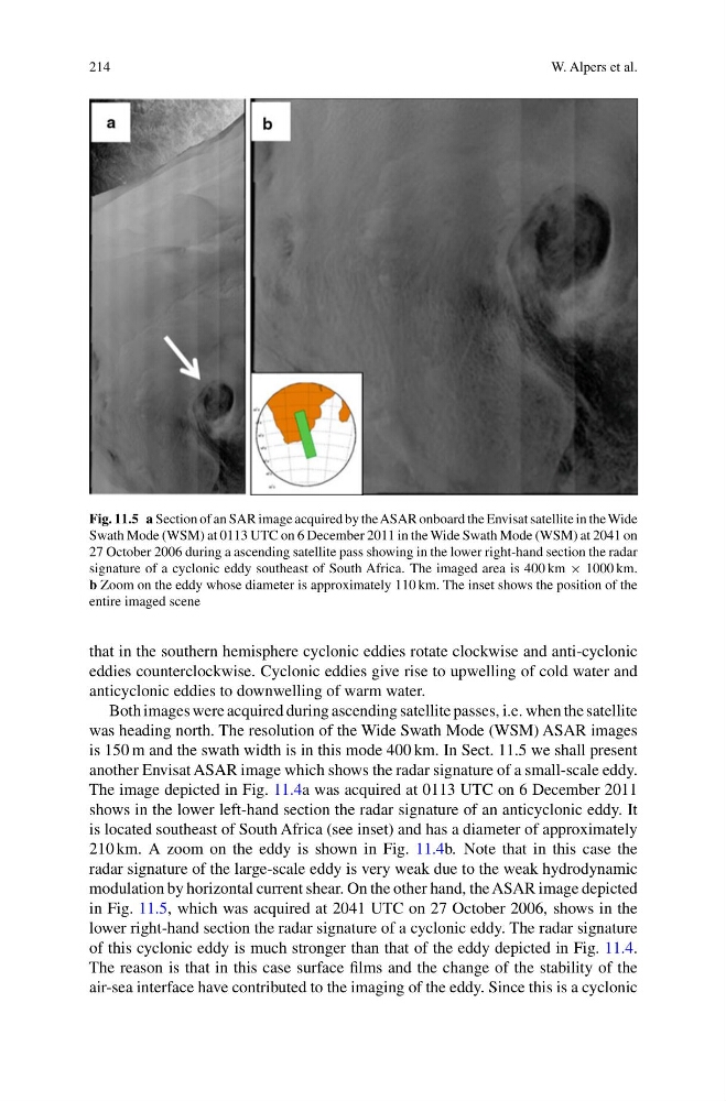
Fig. 11.5 a Section of an SAR image acquired by the ASAR onboard the Envisat satellite in the Wide
Swath Mode (WSM) at 0113 UTC on 6 December 2011 in the Wide Swath Mode (WSM) at 2041 on
27 October 2006 during a ascending satellite pass showing in the lower right-hand section the radar
signature of a cyclonic eddy southeast of South Africa. The imaged area is 400 km × 1000 km.
b Zoom on the eddy whose diameter is approximately 110 km. The inset shows the position of the
entire imaged scene
that in the southern hemisphere cyclonic eddies rotate clockwise and anti-cyclonic
eddies counterclockwise. Cyclonic eddies give rise to upwelling of cold water and
anticyclonic eddies to downwelling of warm water.
Both images were acquired during ascending satellite passes, i.e. when the satellite
was heading north. The resolution of the Wide Swath Mode (WSM) ASAR images
is 150 m and the swath width is in this mode 400 km. In Sect. 11.5 we shall present
another Envisat ASAR image which shows the radar signature of a small-scale eddy.
The image depicted in Fig. 11.4a was acquired at 0113 UTC on 6 December 2011
shows in the lower left-hand section the radar signature of an anticyclonic eddy. It
is located southeast of South Africa (see inset) and has a diameter of approximately
210 km. A zoom on the eddy is shown in Fig. 11.4b. Note that in this case the
radar signature of the large-scale eddy is very weak due to the weak hydrodynamic
modulation by horizontal current shear. On the other hand, the ASAR image depicted
in Fig. 11.5, which was acquired at 2041 UTC on 27 October 2006, shows in the
lower right-hand section the radar signature of a cyclonic eddy. The radar signature
of this cyclonic eddy is much stronger than that of the eddy depicted in Fig. 11.4.
The reason is that in this case surface films and the change of the stability of the
air-sea interface have contributed to the imaging of the eddy. Since this is a cyclonic
W. Alpers et al.
Fig. 11.5 a Section of an SAR image acquired by the ASAR onboard the Envisat satellite in the Wide
Swath Mode (WSM) at 0113 UTC on 6 December 2011 in the Wide Swath Mode (WSM) at 2041 on
27 October 2006 during a ascending satellite pass showing in the lower right-hand section the radar
signature of a cyclonic eddy southeast of South Africa. The imaged area is 400 km × 1000 km.
b Zoom on the eddy whose diameter is approximately 110 km. The inset shows the position of the
entire imaged scene
that in the southern hemisphere cyclonic eddies rotate clockwise and anti-cyclonic
eddies counterclockwise. Cyclonic eddies give rise to upwelling of cold water and
anticyclonic eddies to downwelling of warm water.
Both images were acquired during ascending satellite passes, i.e. when the satellite
was heading north. The resolution of the Wide Swath Mode (WSM) ASAR images
is 150 m and the swath width is in this mode 400 km. In Sect. 11.5 we shall present
another Envisat ASAR image which shows the radar signature of a small-scale eddy.
The image depicted in Fig. 11.4a was acquired at 0113 UTC on 6 December 2011
shows in the lower left-hand section the radar signature of an anticyclonic eddy. It
is located southeast of South Africa (see inset) and has a diameter of approximately
210 km. A zoom on the eddy is shown in Fig. 11.4b. Note that in this case the
radar signature of the large-scale eddy is very weak due to the weak hydrodynamic
modulation by horizontal current shear. On the other hand, the ASAR image depicted
in Fig. 11.5, which was acquired at 2041 UTC on 27 October 2006, shows in the
lower right-hand section the radar signature of a cyclonic eddy. The radar signature
of this cyclonic eddy is much stronger than that of the eddy depicted in Fig. 11.4.
The reason is that in this case surface films and the change of the stability of the
air-sea interface have contributed to the imaging of the eddy. Since this is a cyclonic