

158
A. G. Kostianoy et al.
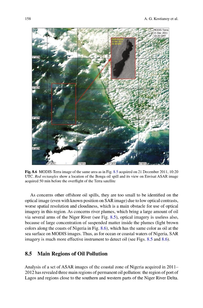
Fig. 8.6 MODIS-Terra image of the same area as in Fig. 8.5 acquired on 21 December 2011, 10:20
UTC. Red rectangles show a location of the Bonga oil spill and its view on Envisat ASAR image
acquired 50 min before the overflight of the Terra satellite
As concerns other offshore oil spills, they are too small to be identified on the
optical image (even with known position on SAR image) due to low optical contrasts,
worse spatial resolution and cloudiness, which is a main obstacle for use of optical
imagery in this region. As concerns river plumes, which bring a large amount of oil
via several arms of the Niger River (see Fig. 8.5), optical imagery is useless also,
because of large concentration of suspended matter inside the plumes (light brown
colors along the coasts of Nigeria in Fig. 8.6), which has the same color as oil at the
sea surface on MODIS images. Thus, as for ocean or coastal waters of Nigeria, SAR
imagery is much more effective instrument to detect oil (see Figs. 8.5 and 8.6).
8.5 Main Regions of Oil Pollution
Analysis of a set of ASAR images of the coastal zone of Nigeria acquired in 2011–
2012 has revealed three main regions of permanent oil pollution: the region of port of
Lagos and regions close to the southern and western parts of the Niger River Delta.
A. G. Kostianoy et al.
Fig. 8.6 MODIS-Terra image of the same area as in Fig. 8.5 acquired on 21 December 2011, 10:20
UTC. Red rectangles show a location of the Bonga oil spill and its view on Envisat ASAR image
acquired 50 min before the overflight of the Terra satellite
As concerns other offshore oil spills, they are too small to be identified on the
optical image (even with known position on SAR image) due to low optical contrasts,
worse spatial resolution and cloudiness, which is a main obstacle for use of optical
imagery in this region. As concerns river plumes, which bring a large amount of oil
via several arms of the Niger River (see Fig. 8.5), optical imagery is useless also,
because of large concentration of suspended matter inside the plumes (light brown
colors along the coasts of Nigeria in Fig. 8.6), which has the same color as oil at the
sea surface on MODIS images. Thus, as for ocean or coastal waters of Nigeria, SAR
imagery is much more effective instrument to detect oil (see Figs. 8.5 and 8.6).
8.5 Main Regions of Oil Pollution
Analysis of a set of ASAR images of the coastal zone of Nigeria acquired in 2011–
2012 has revealed three main regions of permanent oil pollution: the region of port of
Lagos and regions close to the southern and western parts of the Niger River Delta.