

8 Oil Pollution in Coastal Waters of Nigeria
151
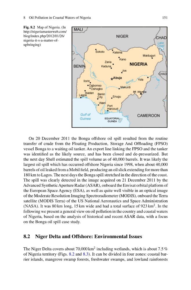
Fig. 8.2 Map of Nigeria. (In
http://nigeriamasterweb.com/
blog/index.php/2012/01/26/
nigeria-it-s-a-matter-ofupbringing)
On 20 December 2011 the Bonga offshore oil spill resulted from the routine
transfer of crude from the Floating Production, Storage And Offloading (FPSO)
vessel Bonga to a waiting oil tanker. An export line linking the FPSO and the tanker
was identified as the likely source, and has been closed and de-pressurized. But
the next day Shell estimated the spill volume as of 40,000 barrels. It was likely the
largest oil spill which has occurred offshore Nigeria since 1998, when about 40,000
barrels of oil leaked from a Mobil field, producing an oil slick extending for more than
180 km to Lagos. The next days the Bonga spill stretched in the direction of the coast.
The spill was clearly detected in the image acquired on 21 December 2011 by the
Advanced Synthetic Aperture Radar (ASAR), onboard the Envisat orbital platform of
the European Space Agency (ESA), as well as quite well visible in an optical image
of the Moderate Resolution Imaging Spectroradiometer (MODIS), onboard the Terra
satellite (MODIS Terra) of the US National Aeronautics and Space Administration
(NASA). It was 80 km long, 15 km wide and had a total surface of 923 km
2 . In the
following we present a general view on oil pollution in the country and coastal waters
of Nigeria, based on the analysis of historical and recent ASAR data, with a focus
on the Bonga oil spill case study.
8.2 Niger Delta and Offshore: Environmental Issues
The Niger Delta covers about 70,000 km
2 including wetlands, which is about 7.5 %
of Nigeria territory (Figs. 8.2 and 8.3). It can be divided in four zones: coastal barrier islands, mangrove swamp forests, freshwater swamps, and lowland rainforests
151
Fig. 8.2 Map of Nigeria. (In
http://nigeriamasterweb.com/
blog/index.php/2012/01/26/
nigeria-it-s-a-matter-ofupbringing)
On 20 December 2011 the Bonga offshore oil spill resulted from the routine
transfer of crude from the Floating Production, Storage And Offloading (FPSO)
vessel Bonga to a waiting oil tanker. An export line linking the FPSO and the tanker
was identified as the likely source, and has been closed and de-pressurized. But
the next day Shell estimated the spill volume as of 40,000 barrels. It was likely the
largest oil spill which has occurred offshore Nigeria since 1998, when about 40,000
barrels of oil leaked from a Mobil field, producing an oil slick extending for more than
180 km to Lagos. The next days the Bonga spill stretched in the direction of the coast.
The spill was clearly detected in the image acquired on 21 December 2011 by the
Advanced Synthetic Aperture Radar (ASAR), onboard the Envisat orbital platform of
the European Space Agency (ESA), as well as quite well visible in an optical image
of the Moderate Resolution Imaging Spectroradiometer (MODIS), onboard the Terra
satellite (MODIS Terra) of the US National Aeronautics and Space Administration
(NASA). It was 80 km long, 15 km wide and had a total surface of 923 km
2 . In the
following we present a general view on oil pollution in the country and coastal waters
of Nigeria, based on the analysis of historical and recent ASAR data, with a focus
on the Bonga oil spill case study.
8.2 Niger Delta and Offshore: Environmental Issues
The Niger Delta covers about 70,000 km
2 including wetlands, which is about 7.5 %
of Nigeria territory (Figs. 8.2 and 8.3). It can be divided in four zones: coastal barrier islands, mangrove swamp forests, freshwater swamps, and lowland rainforests