

7 Water Constituents Assessment at the Sassandra River Mouth (Côte d’Ivoire)
137
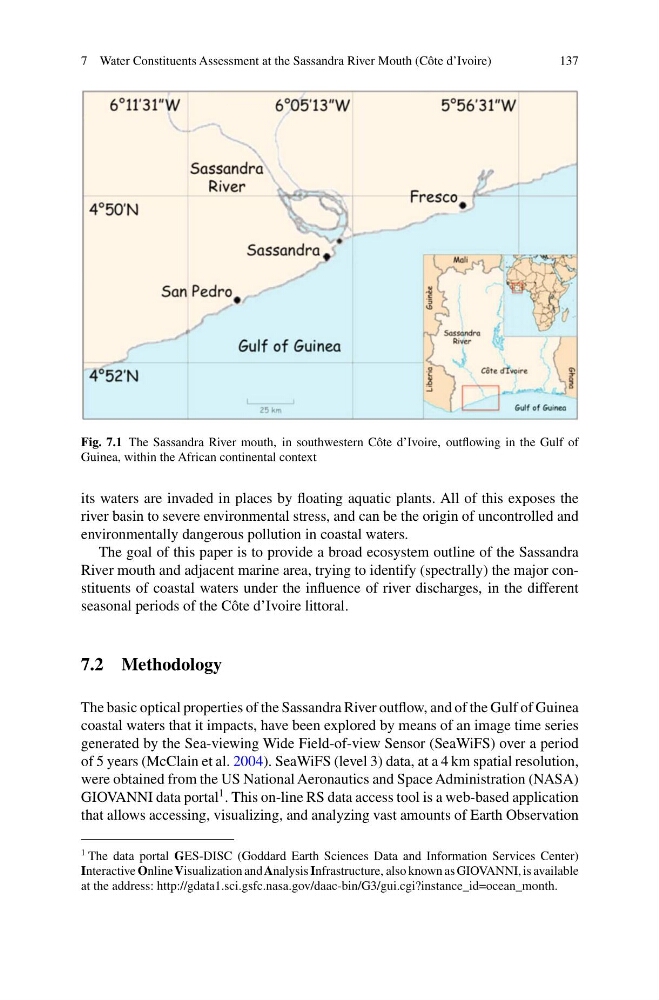
Fig. 7.1 The Sassandra River mouth, in southwestern Côte d’Ivoire, outflowing in the Gulf of
Guinea, within the African continental context
its waters are invaded in places by floating aquatic plants. All of this exposes the
river basin to severe environmental stress, and can be the origin of uncontrolled and
environmentally dangerous pollution in coastal waters.
The goal of this paper is to provide a broad ecosystem outline of the Sassandra
River mouth and adjacent marine area, trying to identify (spectrally) the major constituents of coastal waters under the influence of river discharges, in the different
seasonal periods of the Côte d’Ivoire littoral.
7.2 Methodology
The basic optical properties of the Sassandra River outflow, and of the Gulf of Guinea
coastal waters that it impacts, have been explored by means of an image time series
generated by the Sea-viewing Wide Field-of-view Sensor (SeaWiFS) over a period
of 5 years (McClain et al. 2004). SeaWiFS (level 3) data, at a 4 km spatial resolution,
were obtained from the US National Aeronautics and Space Administration (NASA)
GIOVANNI data portal
1 . This on-line RS data access tool is a web-based application
that allows accessing, visualizing, and analyzing vast amounts of Earth Observation
1 The data portal GES-DISC (Goddard Earth Sciences Data and Information Services Center)
Interactive Online Visualization and Analysis Infrastructure, also known as GIOVANNI, is available
at the address: http://gdata1.sci.gsfc.nasa.gov/daac-bin/G3/gui.cgi?instance_id=ocean_month.
137
Fig. 7.1 The Sassandra River mouth, in southwestern Côte d’Ivoire, outflowing in the Gulf of
Guinea, within the African continental context
its waters are invaded in places by floating aquatic plants. All of this exposes the
river basin to severe environmental stress, and can be the origin of uncontrolled and
environmentally dangerous pollution in coastal waters.
The goal of this paper is to provide a broad ecosystem outline of the Sassandra
River mouth and adjacent marine area, trying to identify (spectrally) the major constituents of coastal waters under the influence of river discharges, in the different
seasonal periods of the Côte d’Ivoire littoral.
7.2 Methodology
The basic optical properties of the Sassandra River outflow, and of the Gulf of Guinea
coastal waters that it impacts, have been explored by means of an image time series
generated by the Sea-viewing Wide Field-of-view Sensor (SeaWiFS) over a period
of 5 years (McClain et al. 2004). SeaWiFS (level 3) data, at a 4 km spatial resolution,
were obtained from the US National Aeronautics and Space Administration (NASA)
GIOVANNI data portal
1 . This on-line RS data access tool is a web-based application
that allows accessing, visualizing, and analyzing vast amounts of Earth Observation
1 The data portal GES-DISC (Goddard Earth Sciences Data and Information Services Center)
Interactive Online Visualization and Analysis Infrastructure, also known as GIOVANNI, is available
at the address: http://gdata1.sci.gsfc.nasa.gov/daac-bin/G3/gui.cgi?instance_id=ocean_month.