

These satellites can carry one or more sensors, and sensors from satellite to
satellite can vary in design and capabilities. Satellite sensors can be either active or
passive (see Sect. 3). Passive sensors can be multispectral (acquiring images across
several different segments of the electromagnetic spectrum) or hyperspectral
(acquiring images across hundreds of segments of the electromagnetic
spectrum—see Sect. 6.2). Passive sensors collect reflective shortwave radiation or
emitted longwave (thermal) radiation. Active sensors can include sonar or radar
(both beyond the scope of this chapter) or Lidar (see Sect. 6.1). The characteristics
of a specific sensor depend on the purposes of the satellite system for which it is
being designed. Multispectral sensors can be designed to acquire reflected radiation
in a very limited range of the electromagnetic spectrum (e.g., blue, green, and red
visible) or a much wider range (the blue visible through the far infrared).
Different models of passive sensors acquire images, basically, in the same way.
The sensor records the energy from either the reflected or re-emitted radiation over
a specific area of the Earth’s surface. Such an area is defined by two parameters—
the image swath, which represents the area of land covered in one orbital pass of the
satellite, and the pixel size, which represents the smallest area that forms an
individual brightness value on the image. This returned energy is directed by a
mirror onto instruments that focus and transmit the energy to detectors. The
detectors record the energy as brightness values in the form of digital numbers.
Sensors vary in their capability to record a range of brightness values; brightness
values are in binary format. For example, Landsats 4–7 use 8 bits, and Landsat
8 uses 12 bits. (An 8-bit sensor can record up to 256 different brightness values for
each pixel, whereas a 12-bit sensor can record up to 4,096.)
The data is transmitted to ground stations positioned in different areas of the
world, depending on the satellite system. The images are rectangular arrays of
pixels. Most images are available for a fee. Processing of Landsat or any other
satellite image requires specialized imaging software. Governments, corporations,
and educational institutions each use a variety of software packages to display and
analyze satellite images. Two private corporations—Google and ESRI—have each
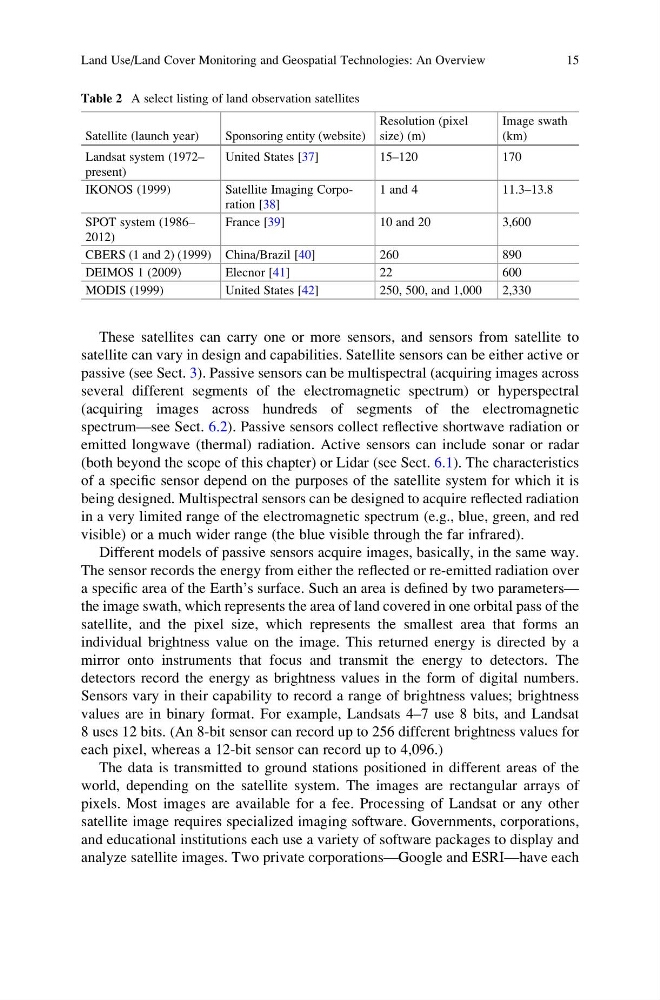
Table 2 A select listing of land observation satellites
Satellite (launch year)
Sponsoring entity (website)
Resolution (pixel
size) (m)
Image swath
(km)
Landsat system (1972–
present)
United States [37]
15–120
170
IKONOS (1999)
Satellite Imaging Corporation [38]
1 and 4
11.3–13.8
SPOT system (1986–
2012)
France [39]
10 and 20
3,600
CBERS (1 and 2) (1999) China/Brazil [40]
260
890
DEIMOS 1 (2009)
Elecnor [41]
22
600
MODIS (1999)
United States [42]
250, 500, and 1,000
2,330
Land Use/Land Cover Monitoring and Geospatial Technologies: An Overview
15
satellite can vary in design and capabilities. Satellite sensors can be either active or
passive (see Sect. 3). Passive sensors can be multispectral (acquiring images across
several different segments of the electromagnetic spectrum) or hyperspectral
(acquiring images across hundreds of segments of the electromagnetic
spectrum—see Sect. 6.2). Passive sensors collect reflective shortwave radiation or
emitted longwave (thermal) radiation. Active sensors can include sonar or radar
(both beyond the scope of this chapter) or Lidar (see Sect. 6.1). The characteristics
of a specific sensor depend on the purposes of the satellite system for which it is
being designed. Multispectral sensors can be designed to acquire reflected radiation
in a very limited range of the electromagnetic spectrum (e.g., blue, green, and red
visible) or a much wider range (the blue visible through the far infrared).
Different models of passive sensors acquire images, basically, in the same way.
The sensor records the energy from either the reflected or re-emitted radiation over
a specific area of the Earth’s surface. Such an area is defined by two parameters—
the image swath, which represents the area of land covered in one orbital pass of the
satellite, and the pixel size, which represents the smallest area that forms an
individual brightness value on the image. This returned energy is directed by a
mirror onto instruments that focus and transmit the energy to detectors. The
detectors record the energy as brightness values in the form of digital numbers.
Sensors vary in their capability to record a range of brightness values; brightness
values are in binary format. For example, Landsats 4–7 use 8 bits, and Landsat
8 uses 12 bits. (An 8-bit sensor can record up to 256 different brightness values for
each pixel, whereas a 12-bit sensor can record up to 4,096.)
The data is transmitted to ground stations positioned in different areas of the
world, depending on the satellite system. The images are rectangular arrays of
pixels. Most images are available for a fee. Processing of Landsat or any other
satellite image requires specialized imaging software. Governments, corporations,
and educational institutions each use a variety of software packages to display and
analyze satellite images. Two private corporations—Google and ESRI—have each
Table 2 A select listing of land observation satellites
Satellite (launch year)
Sponsoring entity (website)
Resolution (pixel
size) (m)
Image swath
(km)
Landsat system (1972–
present)
United States [37]
15–120
170
IKONOS (1999)
Satellite Imaging Corporation [38]
1 and 4
11.3–13.8
SPOT system (1986–
2012)
France [39]
10 and 20
3,600
CBERS (1 and 2) (1999) China/Brazil [40]
260
890
DEIMOS 1 (2009)
Elecnor [41]
22
600
MODIS (1999)
United States [42]
250, 500, and 1,000
2,330
Land Use/Land Cover Monitoring and Geospatial Technologies: An Overview
15