

project (mentioned earlier in Sect. 2.2); most specifically, mapping of land use and
identification of natural resources for New York State (USA) were accomplished by
using Mylar transparencies overlaid on aerial photographs [33], for 1 km
2 cells
[28], and hand-drafted [17]. The land use identified from the aerial photos was then
combined with reference data from other sources (public records, direct observation, etc.); a computerized map was produced from the results [1, 17].
With the increase in computing power, hand delineation of land use from aerial
photos is no longer necessary, and it can be accomplished in either of two ways.
One technique employs computer software that uses specialized algorithms to
evaluate the spectral properties of the image, looking for similarities. Simply put,
once these similarities are identified, the program will assign all pixels with these
spectral values to specific classes. The algorithms will also assign unidentified pixel
values to a specific class, depending on the algorithm’s parameters. Specifics of
these algorithms’ methodologies are beyond the scope of this chapter (see [28] for
some specifics).
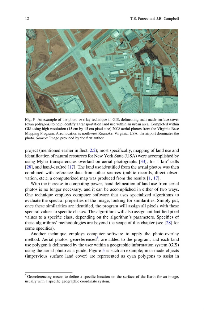
Another technique employs computer software to apply the photo-overlay
method. Aerial photos, georeferenced
3 , are added to the program, and each land
use polygon is delineated by the user within a geographic information system (GIS)
using the aerial photo as a guide. Figure 5 is such an example; man-made objects
(impervious surface land cover) are represented as cyan polygons to assist in
Fig. 5 An example of the photo-overlay technique in GIS, delineating man-made surface cover
(cyan polygons) to help identify a transportation land use within an urban area. Completed within
GIS using high-resolution (15 cm by 15 cm pixel size) 2008 aerial photos from the Virginia Base
Mapping Program. Area location is northwest Roanoke, Virginia, USA; the airport dominates the
photo. Source: Image provided by the first author
3 Georeferencing means to define a specific location on the surface of the Earth for an image,
usually with a specific geographic coordinate system.
12
T.E. Parece and J.B. Campbell
identification of natural resources for New York State (USA) were accomplished by
using Mylar transparencies overlaid on aerial photographs [33], for 1 km
2 cells
[28], and hand-drafted [17]. The land use identified from the aerial photos was then
combined with reference data from other sources (public records, direct observation, etc.); a computerized map was produced from the results [1, 17].
With the increase in computing power, hand delineation of land use from aerial
photos is no longer necessary, and it can be accomplished in either of two ways.
One technique employs computer software that uses specialized algorithms to
evaluate the spectral properties of the image, looking for similarities. Simply put,
once these similarities are identified, the program will assign all pixels with these
spectral values to specific classes. The algorithms will also assign unidentified pixel
values to a specific class, depending on the algorithm’s parameters. Specifics of
these algorithms’ methodologies are beyond the scope of this chapter (see [28] for
some specifics).
Another technique employs computer software to apply the photo-overlay
method. Aerial photos, georeferenced
3 , are added to the program, and each land
use polygon is delineated by the user within a geographic information system (GIS)
using the aerial photo as a guide. Figure 5 is such an example; man-made objects
(impervious surface land cover) are represented as cyan polygons to assist in
Fig. 5 An example of the photo-overlay technique in GIS, delineating man-made surface cover
(cyan polygons) to help identify a transportation land use within an urban area. Completed within
GIS using high-resolution (15 cm by 15 cm pixel size) 2008 aerial photos from the Virginia Base
Mapping Program. Area location is northwest Roanoke, Virginia, USA; the airport dominates the
photo. Source: Image provided by the first author
3 Georeferencing means to define a specific location on the surface of the Earth for an image,
usually with a specific geographic coordinate system.
12
T.E. Parece and J.B. Campbell