

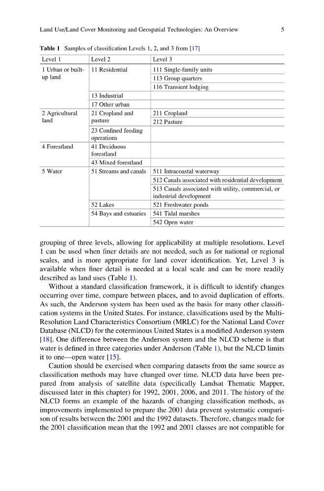
grouping of three levels, allowing for applicability at multiple resolutions. Level
1 can be used when finer details are not needed, such as for national or regional
scales, and is more appropriate for land cover identification. Yet, Level 3 is
available when finer detail is needed at a local scale and can be more readily
described as land uses (Table 1).
Without a standard classification framework, it is difficult to identify changes
occurring over time, compare between places, and to avoid duplication of efforts.
As such, the Anderson system has been used as the basis for many other classification systems in the United States. For instance, classifications used by the MultiResolution Land Characteristics Consortium (MRLC) for the National Land Cover
Database (NLCD) for the coterminous United States is a modified Anderson system
[18]. One difference between the Anderson system and the NLCD scheme is that
water is defined in three categories under Anderson (Table 1), but the NLCD limits
it to one—open water [15].
Caution should be exercised when comparing datasets from the same source as
classification methods may have changed over time. NLCD data have been prepared from analysis of satellite data (specifically Landsat Thematic Mapper,
discussed later in this chapter) for 1992, 2001, 2006, and 2011. The history of the
NLCD forms an example of the hazards of changing classification methods, as
improvements implemented to prepare the 2001 data prevent systematic comparison of results between the 2001 and the 1992 datasets. Therefore, changes made for
the 2001 classification mean that the 1992 and 2001 classes are not compatible for
Table 1 Samples of classification Levels 1, 2, and 3 from [17]
Level 1
Level 2
Level 3
1 Urban or builtup land
11 Residential
111 Single-family units
113 Group quarters
116 Transient lodging
13 Industrial
17 Other urban
2 Agricultural
land
21 Cropland and
pasture
211 Cropland
212 Pasture
23 Confined feeding
operations
4 Forestland
41 Deciduous
forestland
43 Mixed forestland
5 Water
51 Streams and canals 511 Intracoastal waterway
512 Canals associated with residential development
513 Canals associated with utility, commercial, or
industrial development
52 Lakes
521 Freshwater ponds
54 Bays and estuaries 541 Tidal marshes
542 Open water
Land Use/Land Cover Monitoring and Geospatial Technologies: An Overview
5
1 can be used when finer details are not needed, such as for national or regional
scales, and is more appropriate for land cover identification. Yet, Level 3 is
available when finer detail is needed at a local scale and can be more readily
described as land uses (Table 1).
Without a standard classification framework, it is difficult to identify changes
occurring over time, compare between places, and to avoid duplication of efforts.
As such, the Anderson system has been used as the basis for many other classification systems in the United States. For instance, classifications used by the MultiResolution Land Characteristics Consortium (MRLC) for the National Land Cover
Database (NLCD) for the coterminous United States is a modified Anderson system
[18]. One difference between the Anderson system and the NLCD scheme is that
water is defined in three categories under Anderson (Table 1), but the NLCD limits
it to one—open water [15].
Caution should be exercised when comparing datasets from the same source as
classification methods may have changed over time. NLCD data have been prepared from analysis of satellite data (specifically Landsat Thematic Mapper,
discussed later in this chapter) for 1992, 2001, 2006, and 2011. The history of the
NLCD forms an example of the hazards of changing classification methods, as
improvements implemented to prepare the 2001 data prevent systematic comparison of results between the 2001 and the 1992 datasets. Therefore, changes made for
the 2001 classification mean that the 1992 and 2001 classes are not compatible for
Table 1 Samples of classification Levels 1, 2, and 3 from [17]
Level 1
Level 2
Level 3
1 Urban or builtup land
11 Residential
111 Single-family units
113 Group quarters
116 Transient lodging
13 Industrial
17 Other urban
2 Agricultural
land
21 Cropland and
pasture
211 Cropland
212 Pasture
23 Confined feeding
operations
4 Forestland
41 Deciduous
forestland
43 Mixed forestland
5 Water
51 Streams and canals 511 Intracoastal waterway
512 Canals associated with residential development
513 Canals associated with utility, commercial, or
industrial development
52 Lakes
521 Freshwater ponds
54 Bays and estuaries 541 Tidal marshes
542 Open water
Land Use/Land Cover Monitoring and Geospatial Technologies: An Overview
5