

2.2 Land Use and Land Cover Classification Systems
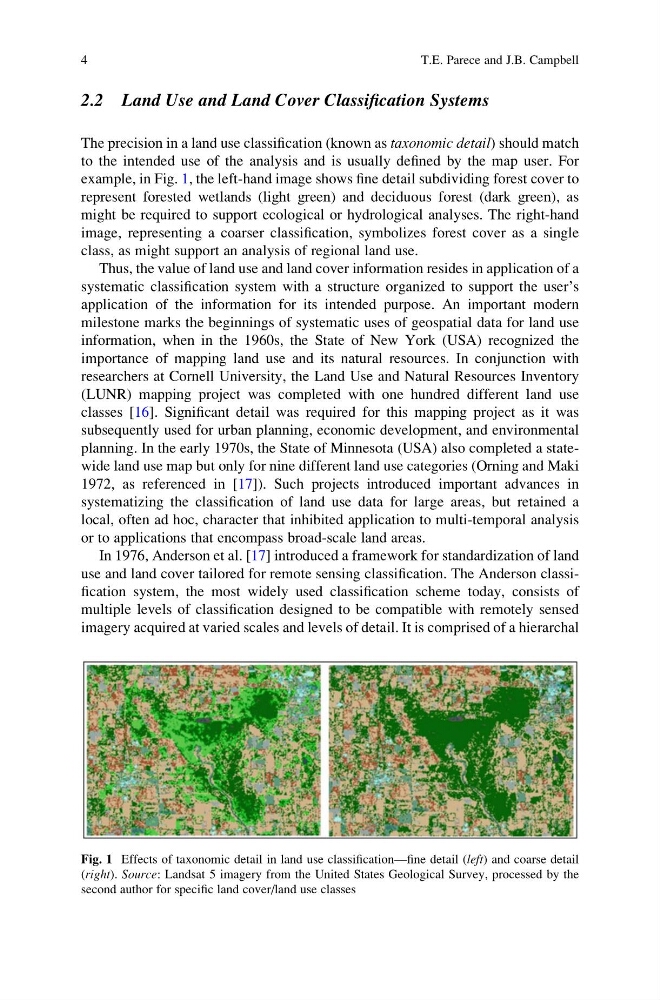
The precision in a land use classification (known as taxonomic detail) should match
to the intended use of the analysis and is usually defined by the map user. For
example, in Fig. 1, the left-hand image shows fine detail subdividing forest cover to
represent forested wetlands (light green) and deciduous forest (dark green), as
might be required to support ecological or hydrological analyses. The right-hand
image, representing a coarser classification, symbolizes forest cover as a single
class, as might support an analysis of regional land use.
Thus, the value of land use and land cover information resides in application of a
systematic classification system with a structure organized to support the user’s
application of the information for its intended purpose. An important modern
milestone marks the beginnings of systematic uses of geospatial data for land use
information, when in the 1960s, the State of New York (USA) recognized the
importance of mapping land use and its natural resources. In conjunction with
researchers at Cornell University, the Land Use and Natural Resources Inventory
(LUNR) mapping project was completed with one hundred different land use
classes [16]. Significant detail was required for this mapping project as it was
subsequently used for urban planning, economic development, and environmental
planning. In the early 1970s, the State of Minnesota (USA) also completed a statewide land use map but only for nine different land use categories (Orning and Maki
1972, as referenced in [17]). Such projects introduced important advances in
systematizing the classification of land use data for large areas, but retained a
local, often ad hoc, character that inhibited application to multi-temporal analysis
or to applications that encompass broad-scale land areas.
In 1976, Anderson et al. [17] introduced a framework for standardization of land
use and land cover tailored for remote sensing classification. The Anderson classification system, the most widely used classification scheme today, consists of
multiple levels of classification designed to be compatible with remotely sensed
imagery acquired at varied scales and levels of detail. It is comprised of a hierarchal
Fig. 1 Effects of taxonomic detail in land use classification—fine detail (left) and coarse detail
(right). Source: Landsat 5 imagery from the United States Geological Survey, processed by the
second author for specific land cover/land use classes
4
T.E. Parece and J.B. Campbell
The precision in a land use classification (known as taxonomic detail) should match
to the intended use of the analysis and is usually defined by the map user. For
example, in Fig. 1, the left-hand image shows fine detail subdividing forest cover to
represent forested wetlands (light green) and deciduous forest (dark green), as
might be required to support ecological or hydrological analyses. The right-hand
image, representing a coarser classification, symbolizes forest cover as a single
class, as might support an analysis of regional land use.
Thus, the value of land use and land cover information resides in application of a
systematic classification system with a structure organized to support the user’s
application of the information for its intended purpose. An important modern
milestone marks the beginnings of systematic uses of geospatial data for land use
information, when in the 1960s, the State of New York (USA) recognized the
importance of mapping land use and its natural resources. In conjunction with
researchers at Cornell University, the Land Use and Natural Resources Inventory
(LUNR) mapping project was completed with one hundred different land use
classes [16]. Significant detail was required for this mapping project as it was
subsequently used for urban planning, economic development, and environmental
planning. In the early 1970s, the State of Minnesota (USA) also completed a statewide land use map but only for nine different land use categories (Orning and Maki
1972, as referenced in [17]). Such projects introduced important advances in
systematizing the classification of land use data for large areas, but retained a
local, often ad hoc, character that inhibited application to multi-temporal analysis
or to applications that encompass broad-scale land areas.
In 1976, Anderson et al. [17] introduced a framework for standardization of land
use and land cover tailored for remote sensing classification. The Anderson classification system, the most widely used classification scheme today, consists of
multiple levels of classification designed to be compatible with remotely sensed
imagery acquired at varied scales and levels of detail. It is comprised of a hierarchal
Fig. 1 Effects of taxonomic detail in land use classification—fine detail (left) and coarse detail
(right). Source: Landsat 5 imagery from the United States Geological Survey, processed by the
second author for specific land cover/land use classes
4
T.E. Parece and J.B. Campbell