

server, or GeoServer [43]. The Apache Tomcat [44] is a web server software which
runs in conjunction with the application server to provide browser-based activity in
the form of html web pages commonly found in any Internet-driven application.
The spatial database consists of the robust and scalable PostgreSQL [45] relational
database. Its capacity to store geometry for the watersheds and withdrawal points
within the database is aided by an extension called PostGIS [46].
These three components of the system take user input in the form of map clicks,
communicate with each other through a series of scripts to retrieve data from the
spatial database, and deliver it back to the user interface in the form of map feature
highlights, tabular data in tables, and interactive charts. While there are numerous
methods and software architectures that can accomplish the same tasks as described
in this section, this architecture was chosen for its use of open-source software and
scalability.
4 Results and Discussion
4.1 Water Withdrawals in the Upper Potomac Basin
The tool developed for this project allows analysis of total withdrawals and
consumptive use in the upper Potomac Basin, including trends in time and differences during drought and non-drought years. This is of interest to Washington, DC,
metropolitan area water supply planners as water consumptively used upstream will
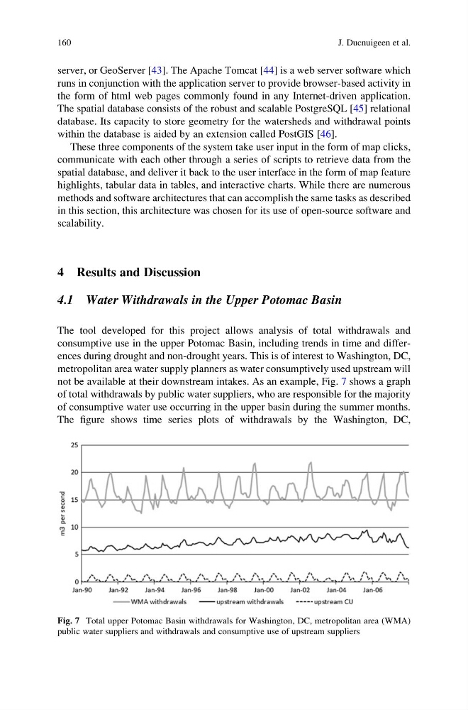
not be available at their downstream intakes. As an example, Fig. 7 shows a graph
of total withdrawals by public water suppliers, who are responsible for the majority
of consumptive water use occurring in the upper basin during the summer months.
The figure shows time series plots of withdrawals by the Washington, DC,
Fig. 7 Total upper Potomac Basin withdrawals for Washington, DC, metropolitan area (WMA)
public water suppliers and withdrawals and consumptive use of upstream suppliers
160
J. Ducnuigeen et al.
runs in conjunction with the application server to provide browser-based activity in
the form of html web pages commonly found in any Internet-driven application.
The spatial database consists of the robust and scalable PostgreSQL [45] relational
database. Its capacity to store geometry for the watersheds and withdrawal points
within the database is aided by an extension called PostGIS [46].
These three components of the system take user input in the form of map clicks,
communicate with each other through a series of scripts to retrieve data from the
spatial database, and deliver it back to the user interface in the form of map feature
highlights, tabular data in tables, and interactive charts. While there are numerous
methods and software architectures that can accomplish the same tasks as described
in this section, this architecture was chosen for its use of open-source software and
scalability.
4 Results and Discussion
4.1 Water Withdrawals in the Upper Potomac Basin
The tool developed for this project allows analysis of total withdrawals and
consumptive use in the upper Potomac Basin, including trends in time and differences during drought and non-drought years. This is of interest to Washington, DC,
metropolitan area water supply planners as water consumptively used upstream will
not be available at their downstream intakes. As an example, Fig. 7 shows a graph
of total withdrawals by public water suppliers, who are responsible for the majority
of consumptive water use occurring in the upper basin during the summer months.
The figure shows time series plots of withdrawals by the Washington, DC,
Fig. 7 Total upper Potomac Basin withdrawals for Washington, DC, metropolitan area (WMA)
public water suppliers and withdrawals and consumptive use of upstream suppliers
160
J. Ducnuigeen et al.