

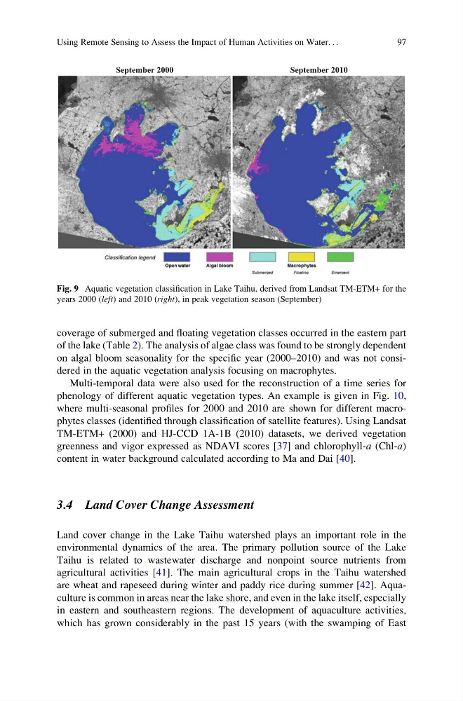
coverage of submerged and floating vegetation classes occurred in the eastern part
of the lake (Table 2). The analysis of algae class was found to be strongly dependent
on algal bloom seasonality for the specific year (2000–2010) and was not considered in the aquatic vegetation analysis focusing on macrophytes.
Multi-temporal data were also used for the reconstruction of a time series for
phenology of different aquatic vegetation types. An example is given in Fig. 10,
where multi-seasonal profiles for 2000 and 2010 are shown for different macrophytes classes (identified through classification of satellite features). Using Landsat
TM-ETM+ (2000) and HJ-CCD 1A-1B (2010) datasets, we derived vegetation
greenness and vigor expressed as NDAVI scores [37] and chlorophyll-a (Chl-a)
content in water background calculated according to Ma and Dai [40].
3.4 Land Cover Change Assessment
Land cover change in the Lake Taihu watershed plays an important role in the
environmental dynamics of the area. The primary pollution source of the Lake
Taihu is related to wastewater discharge and nonpoint source nutrients from
agricultural activities [41]. The main agricultural crops in the Taihu watershed
are wheat and rapeseed during winter and paddy rice during summer [42]. Aquaculture is common in areas near the lake shore, and even in the lake itself, especially
in eastern and southeastern regions. The development of aquaculture activities,
which has grown considerably in the past 15 years (with the swamping of East
September 2000
September 2010
Fig. 9 Aquatic vegetation classification in Lake Taihu, derived from Landsat TM-ETM+ for the
years 2000 (left) and 2010 (right), in peak vegetation season (September)
Using Remote Sensing to Assess the Impact of Human Activities on Water. . .
97
of the lake (Table 2). The analysis of algae class was found to be strongly dependent
on algal bloom seasonality for the specific year (2000–2010) and was not considered in the aquatic vegetation analysis focusing on macrophytes.
Multi-temporal data were also used for the reconstruction of a time series for
phenology of different aquatic vegetation types. An example is given in Fig. 10,
where multi-seasonal profiles for 2000 and 2010 are shown for different macrophytes classes (identified through classification of satellite features). Using Landsat
TM-ETM+ (2000) and HJ-CCD 1A-1B (2010) datasets, we derived vegetation
greenness and vigor expressed as NDAVI scores [37] and chlorophyll-a (Chl-a)
content in water background calculated according to Ma and Dai [40].
3.4 Land Cover Change Assessment
Land cover change in the Lake Taihu watershed plays an important role in the
environmental dynamics of the area. The primary pollution source of the Lake
Taihu is related to wastewater discharge and nonpoint source nutrients from
agricultural activities [41]. The main agricultural crops in the Taihu watershed
are wheat and rapeseed during winter and paddy rice during summer [42]. Aquaculture is common in areas near the lake shore, and even in the lake itself, especially
in eastern and southeastern regions. The development of aquaculture activities,
which has grown considerably in the past 15 years (with the swamping of East
September 2000
September 2010
Fig. 9 Aquatic vegetation classification in Lake Taihu, derived from Landsat TM-ETM+ for the
years 2000 (left) and 2010 (right), in peak vegetation season (September)
Using Remote Sensing to Assess the Impact of Human Activities on Water. . .
97