

390
20.3.7.2 Turbidity
Wetlands in Karnataka are classifi ed into low,
medium and high turbid based on the turbidity
values. Amongst 620 surveyed wetlands, about
200 wetlands have low turbidity, 222 moderate
and 198 high turbidity. Tanks (161) have the lowest turbidity, followed by reservoirs (36), lakes/
ponds (2) and oxbow lakes (1).
20.3.7.3 Aquatic Vegetation Status
On the basis of vegetation, wetlands of Karnataka
have four zones, namely , completely vegetated
(CV), partially vegetated (PV), vegetation on
fringes (VF) and no vegetation (NV). Of the 682
wetlands in Karnataka, 517 do not have vegetation, out of which 417 are tanks. Eighty-three
tanks show partially vegetated condition, 54 have
vegetation on fringes and 7 are completely
vegetated.
20.3.7.4 Seasonal Variation in Water
Spread of Wetlands
The total water spread area in pre-monsoon is
204,053.74 ha, while in post-monsoon it is
246,643.00 ha. Out of 682 wetlands in the State,
71 have shown water spread <56.25 ha (Rege
et al. 1996 ). Reservoirs have shown considerable
variations from post-monsoon (167,268 ha) to
pre-monsoon (138,684.25 ha). The coastal wetlands do not generally show any signifi cant variations in their water spread area. Most of the tanks
dry up during pre-monsoon season.
20.3.7.5 Present Status
Deforestation and other anthropogenic activities
have been accelerating soil erosion causing
increased sedimentation and resulting in shrinkage of area under wetlands. Many wetlands of
Karnataka have already been lost in the process
of urbanisation. Further, the peripheral areas of
many wetlands have been encroached for settlements. Many wetlands are subjected to infl ows of
domestic sewage, solid waste and industrial
effl uents, agricultural run-off, etc. These have
been declining their quality. These threats have
degraded species diversity and the productivity
of the wetlands. In addition, many reservoirs and
other waterbodies in Karnataka are facing the
problem of siltation. The number of wetlands in
Karnataka has halved during the last century.
20.3.7.6 Bengaluru (Bangalore)
Scenario
Bengaluru City once had a large number of lakes,
ponds and marshy wetlands, which ensured a
high level of groundwater table and pleasant climate. It is a great pity that many lakes and ponds
have already disappeared due to various anthropogenic activities. In Bengaluru too, the word
‘lake’ is commonly used for ‘wetlands’.
Distribution of Lakes in Bengaluru
Wetlands of Bengaluru occupy about 4.8 % of the
city’s geographical area (640 km
2 ) (Krishna et al.
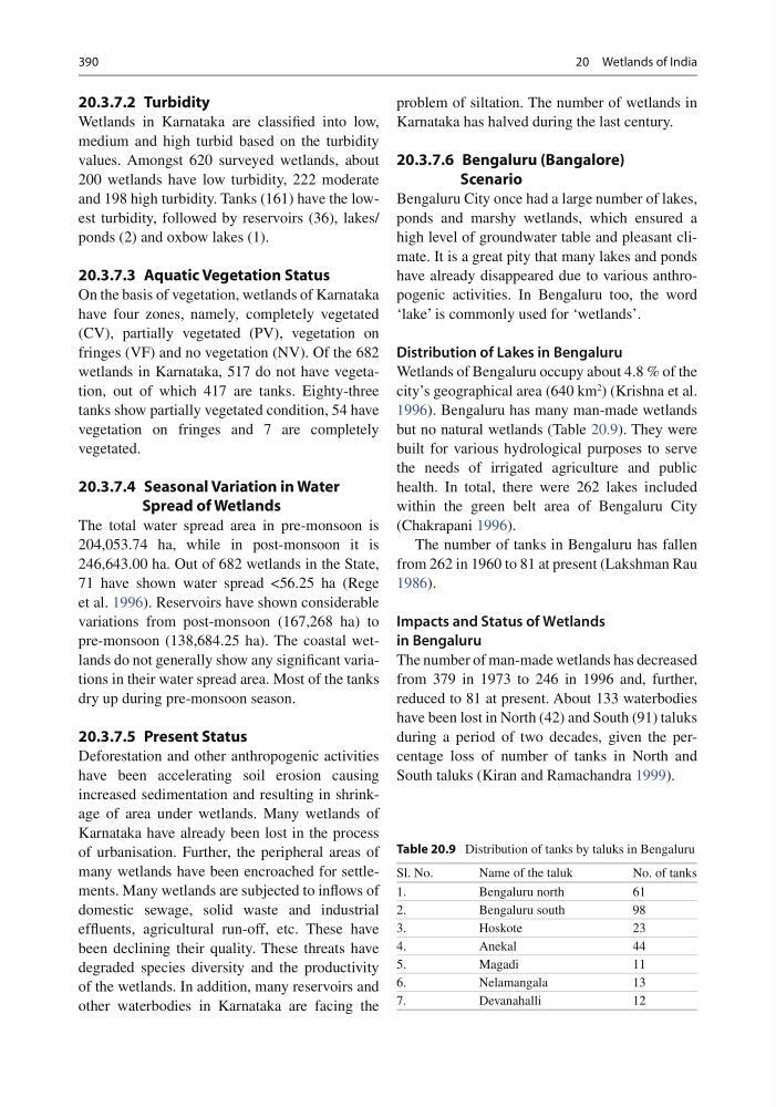
1996 ). Bengaluru has many man-made wetlands
but no natural wetlands (Table 20.9 ). They were
built for various hydrological purposes to serve
the needs of irrigated agriculture and public
health. In total, there were 262 lakes included
within the green belt area of Bengaluru City
(Chakrapani 1996 ).
The number of tanks in Bengaluru has fallen
from 262 in 1960 to 81 at present (Lakshman Rau
1986 ).
Impacts and Status of Wetlands
in Bengaluru
The number of man-made wetlands has decreased
from 379 in 1973 to 246 in 1996 and, further,
reduced to 81 at present. About 133 waterbodies
have been lost in North (42) and South (91) taluks
during a period of two decades, given the percentage loss of number of tanks in North and
South taluks (Kiran and Ramachandra 1999 ).
Table 20.9 Distribution of tanks by taluks in Bengaluru
Sl. No.
Name of the taluk
No. of tanks
1.
Bengaluru north
61
2.
Bengaluru south
98
3.
Hoskote
23
4.
Anekal
44
5.
Magadi
11
6.
Nelamangala
13
7.
Devanahalli
12
20 Wetlands of India
20.3.7.2 Turbidity
Wetlands in Karnataka are classifi ed into low,
medium and high turbid based on the turbidity
values. Amongst 620 surveyed wetlands, about
200 wetlands have low turbidity, 222 moderate
and 198 high turbidity. Tanks (161) have the lowest turbidity, followed by reservoirs (36), lakes/
ponds (2) and oxbow lakes (1).
20.3.7.3 Aquatic Vegetation Status
On the basis of vegetation, wetlands of Karnataka
have four zones, namely , completely vegetated
(CV), partially vegetated (PV), vegetation on
fringes (VF) and no vegetation (NV). Of the 682
wetlands in Karnataka, 517 do not have vegetation, out of which 417 are tanks. Eighty-three
tanks show partially vegetated condition, 54 have
vegetation on fringes and 7 are completely
vegetated.
20.3.7.4 Seasonal Variation in Water
Spread of Wetlands
The total water spread area in pre-monsoon is
204,053.74 ha, while in post-monsoon it is
246,643.00 ha. Out of 682 wetlands in the State,
71 have shown water spread <56.25 ha (Rege
et al. 1996 ). Reservoirs have shown considerable
variations from post-monsoon (167,268 ha) to
pre-monsoon (138,684.25 ha). The coastal wetlands do not generally show any signifi cant variations in their water spread area. Most of the tanks
dry up during pre-monsoon season.
20.3.7.5 Present Status
Deforestation and other anthropogenic activities
have been accelerating soil erosion causing
increased sedimentation and resulting in shrinkage of area under wetlands. Many wetlands of
Karnataka have already been lost in the process
of urbanisation. Further, the peripheral areas of
many wetlands have been encroached for settlements. Many wetlands are subjected to infl ows of
domestic sewage, solid waste and industrial
effl uents, agricultural run-off, etc. These have
been declining their quality. These threats have
degraded species diversity and the productivity
of the wetlands. In addition, many reservoirs and
other waterbodies in Karnataka are facing the
problem of siltation. The number of wetlands in
Karnataka has halved during the last century.
20.3.7.6 Bengaluru (Bangalore)
Scenario
Bengaluru City once had a large number of lakes,
ponds and marshy wetlands, which ensured a
high level of groundwater table and pleasant climate. It is a great pity that many lakes and ponds
have already disappeared due to various anthropogenic activities. In Bengaluru too, the word
‘lake’ is commonly used for ‘wetlands’.
Distribution of Lakes in Bengaluru
Wetlands of Bengaluru occupy about 4.8 % of the
city’s geographical area (640 km
2 ) (Krishna et al.
1996 ). Bengaluru has many man-made wetlands
but no natural wetlands (Table 20.9 ). They were
built for various hydrological purposes to serve
the needs of irrigated agriculture and public
health. In total, there were 262 lakes included
within the green belt area of Bengaluru City
(Chakrapani 1996 ).
The number of tanks in Bengaluru has fallen
from 262 in 1960 to 81 at present (Lakshman Rau
1986 ).
Impacts and Status of Wetlands
in Bengaluru
The number of man-made wetlands has decreased
from 379 in 1973 to 246 in 1996 and, further,
reduced to 81 at present. About 133 waterbodies
have been lost in North (42) and South (91) taluks
during a period of two decades, given the percentage loss of number of tanks in North and
South taluks (Kiran and Ramachandra 1999 ).
Table 20.9 Distribution of tanks by taluks in Bengaluru
Sl. No.
Name of the taluk
No. of tanks
1.
Bengaluru north
61
2.
Bengaluru south
98
3.
Hoskote
23
4.
Anekal
44
5.
Magadi
11
6.
Nelamangala
13
7.
Devanahalli
12
20 Wetlands of India