

168
A. Sukenik et al.
2 The Underwater-Towed Undulating Monitoring System
(U-TUMS)
The U-TUMS is composed of a vehicle (carrier), a set of sensors, and navigation
devices (geographic positioning system-GPS, SONAR, and speedometer) which
are interconnected and operated via an on-board computer (Fig. 2). The
underwater-towed undulating vehicle MiniBAT (GuildLine Canada) is loaded
with: (I) a multisensor probe CTD that measures water electric conductivity,
temperature, and depth (Applied Microsystems Limited, Canada); (2) an optical
backscatter sensor that measures water turbidity (OBS-3, D&A Instrument
Company, USA), and (3) a flurometer for sensing chlorophyll (MinitracaII,
Chelsea Instrument, UK). The fast time response of these sensors assures an
accurate measurement at a distance resolution of less than 15 cm within the water
column, while the vehicle is towed at a speed of 4.5 knots and undulates (diving or
climbing) at rates of up to 90 cm s -1.
:tI2 Vdc
POWER
MODULE
I RS232 CABLE
GPSDISPLAY
'--- Y- C - AB - L-E-"I
INSTRUMENT
DATA
MlnlBAT
CONTROL
I
TOW CABLE
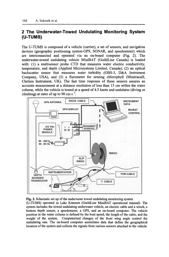
Fig. 2. Schematic set up of the underwater towed undulating monitoring system
(V-TUMS) operated in Lake Kinneret (GuildLine MiniBAT operational manual). The
system includes the towed undulating underwater vehicle, an electric cable and a winch, a
bottom depth sensor, a speedometer, a GPS, and an on-board computer. The vehicle
position in the water column is defined by the boat speed, the length of the cable, and the
weight of the system. Computerized changes of the front wing angle control the
undulating rate. The on-board computer assimilates data that define the geographical
location of the system and coIlects the signals from various sensors attached to the vehicle
A. Sukenik et al.
2 The Underwater-Towed Undulating Monitoring System
(U-TUMS)
The U-TUMS is composed of a vehicle (carrier), a set of sensors, and navigation
devices (geographic positioning system-GPS, SONAR, and speedometer) which
are interconnected and operated via an on-board computer (Fig. 2). The
underwater-towed undulating vehicle MiniBAT (GuildLine Canada) is loaded
with: (I) a multisensor probe CTD that measures water electric conductivity,
temperature, and depth (Applied Microsystems Limited, Canada); (2) an optical
backscatter sensor that measures water turbidity (OBS-3, D&A Instrument
Company, USA), and (3) a flurometer for sensing chlorophyll (MinitracaII,
Chelsea Instrument, UK). The fast time response of these sensors assures an
accurate measurement at a distance resolution of less than 15 cm within the water
column, while the vehicle is towed at a speed of 4.5 knots and undulates (diving or
climbing) at rates of up to 90 cm s -1.
:tI2 Vdc
POWER
MODULE
I RS232 CABLE
GPSDISPLAY
'--- Y- C - AB - L-E-"I
INSTRUMENT
DATA
MlnlBAT
CONTROL
I
TOW CABLE
Fig. 2. Schematic set up of the underwater towed undulating monitoring system
(V-TUMS) operated in Lake Kinneret (GuildLine MiniBAT operational manual). The
system includes the towed undulating underwater vehicle, an electric cable and a winch, a
bottom depth sensor, a speedometer, a GPS, and an on-board computer. The vehicle
position in the water column is defined by the boat speed, the length of the cable, and the
weight of the system. Computerized changes of the front wing angle control the
undulating rate. The on-board computer assimilates data that define the geographical
location of the system and coIlects the signals from various sensors attached to the vehicle