

91
Imprecise positioning can also be caused by the distinct visual acuity among different observers and by wind and swell (sea state). Morete (2007) demonstrated that
after repeated readings of the same target the maximum variation of positioning
inter and intra-observers were 20″. For example, from a LBS 37 m high, for a target
distant 540 m, 20″ cause a variation of 0.8 m. However, with greater distances, a 20″
variation begins to portray a bigger positioning error, at a range of 3.5 km the error
is about ±33 m, at 5 km the error is about 70 m (Fig. 4.7). Thus it is important the
maintenance of the same observer within the same observation (survey, scan or
focal follow). Restriction of data collection to lower winds (maximum 17 knots) and
Beaufort sea state condition (maximum 4) when the study requires very precise
positioning, as in studies of whalewatching interaction, in which distance between
boat and target animals must be accurate. Also, there is some decrease of precision
with increasing target’s distance from the observer, because the further away, the
same vertical angle amplitude, correspond to a larger area.
Old theodolite models had a maximum internal precision of 20″ being another
source of imprecision. Whenever possible, it is advisable to use modern models of
theodolite/total station, which has a lower intrinsic error, with 5″ precision. All
these sources of imprecisions will depend on the height of the land-station, if it is
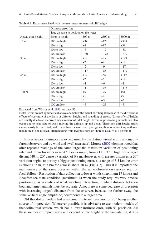
Table 4.1 Errors associated with incorrect measurements of cliff height
Actual cliff height
Distance error (m)
True distance to position on the water
Error in height
500 m
2500 m
5000 m
15 m
100 cm high
+34
+173
+388
10 cm high
+4
+17
+39
10 cm low
−3
−17
−38
100 cm low
−30
−172
−379
30 m
100 cm high
+17
+85
+179
10 cm high
+2
+8
+18
10 cm low
−2
−9
−17
100 cm low
−17
−85
−177
45 m
100 cm high
+12
+56
+117
10 cm high
+2
+5
+12
10 cm low
−1
−6
−11
100 cm low
−11
−56
−116
100 m
100 cm high
+5
+25
+51
10 cm high
+1
+2
+5
10 cm low
0
−3
−5
100 cm low
−5
−25
−51
Extracted from Würsig et al. 1991, on page 83
Note: Errors are not symmetrical above and below the actual cliff height because of the differential
effects of curvature of the Earth at different heights and rounding of errors. (Errors of cliff height
are usually due to an incorrect measurement of tidal height. Errors of positioning animals can also
occur due to heat haze or swell moving the animals up and down. These non cliff height errors
cannot easily be corrected, and if heat haze or swells are prodigious, theodolite tracking with one
theodolite is not advised. Triangulating from two positions on shore is usually still possible)
4 Land-Based Station Studies of Aquatic Mammals in Latin America: Understanding…
Imprecise positioning can also be caused by the distinct visual acuity among different observers and by wind and swell (sea state). Morete (2007) demonstrated that
after repeated readings of the same target the maximum variation of positioning
inter and intra-observers were 20″. For example, from a LBS 37 m high, for a target
distant 540 m, 20″ cause a variation of 0.8 m. However, with greater distances, a 20″
variation begins to portray a bigger positioning error, at a range of 3.5 km the error
is about ±33 m, at 5 km the error is about 70 m (Fig. 4.7). Thus it is important the
maintenance of the same observer within the same observation (survey, scan or
focal follow). Restriction of data collection to lower winds (maximum 17 knots) and
Beaufort sea state condition (maximum 4) when the study requires very precise
positioning, as in studies of whalewatching interaction, in which distance between
boat and target animals must be accurate. Also, there is some decrease of precision
with increasing target’s distance from the observer, because the further away, the
same vertical angle amplitude, correspond to a larger area.
Old theodolite models had a maximum internal precision of 20″ being another
source of imprecision. Whenever possible, it is advisable to use modern models of
theodolite/total station, which has a lower intrinsic error, with 5″ precision. All
these sources of imprecisions will depend on the height of the land-station, if it is
Table 4.1 Errors associated with incorrect measurements of cliff height
Actual cliff height
Distance error (m)
True distance to position on the water
Error in height
500 m
2500 m
5000 m
15 m
100 cm high
+34
+173
+388
10 cm high
+4
+17
+39
10 cm low
−3
−17
−38
100 cm low
−30
−172
−379
30 m
100 cm high
+17
+85
+179
10 cm high
+2
+8
+18
10 cm low
−2
−9
−17
100 cm low
−17
−85
−177
45 m
100 cm high
+12
+56
+117
10 cm high
+2
+5
+12
10 cm low
−1
−6
−11
100 cm low
−11
−56
−116
100 m
100 cm high
+5
+25
+51
10 cm high
+1
+2
+5
10 cm low
0
−3
−5
100 cm low
−5
−25
−51
Extracted from Würsig et al. 1991, on page 83
Note: Errors are not symmetrical above and below the actual cliff height because of the differential
effects of curvature of the Earth at different heights and rounding of errors. (Errors of cliff height
are usually due to an incorrect measurement of tidal height. Errors of positioning animals can also
occur due to heat haze or swell moving the animals up and down. These non cliff height errors
cannot easily be corrected, and if heat haze or swells are prodigious, theodolite tracking with one
theodolite is not advised. Triangulating from two positions on shore is usually still possible)
4 Land-Based Station Studies of Aquatic Mammals in Latin America: Understanding…