

92
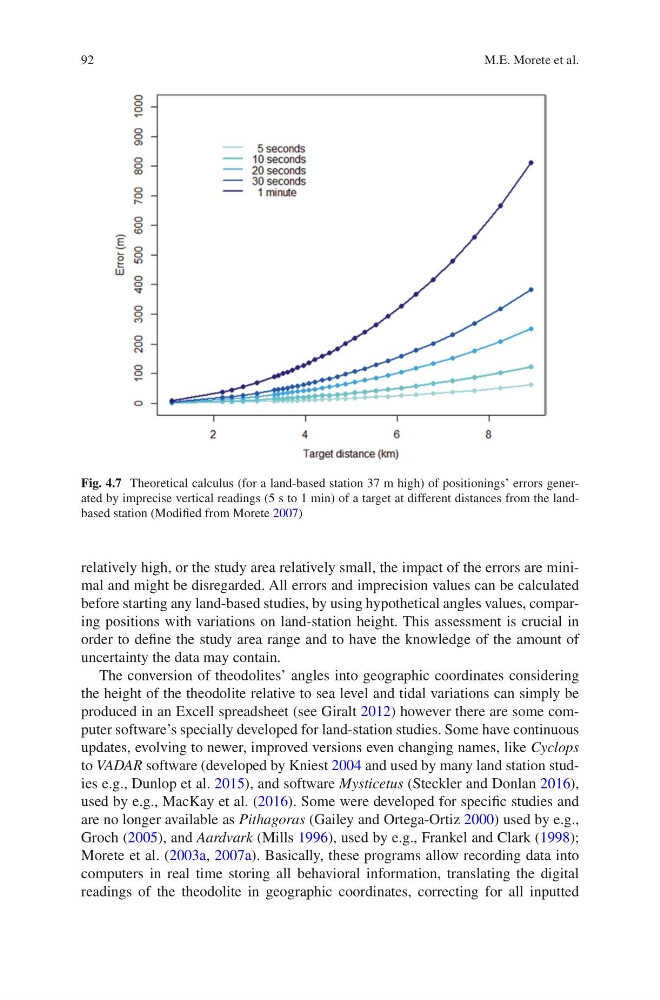
relatively high, or the study area relatively small, the impact of the errors are minimal and might be disregarded. All errors and imprecision values can be calculated
before starting any land-based studies, by using hypothetical angles values, comparing positions with variations on land-station height. This assessment is crucial in
order to define the study area range and to have the knowledge of the amount of
uncertainty the data may contain.
The conversion of theodolites’ angles into geographic coordinates considering
the height of the theodolite relative to sea level and tidal variations can simply be
produced in an Excell spreadsheet (see Giralt 2012) however there are some computer software’s specially developed for land-station studies. Some have continuous
updates, evolving to newer, improved versions even changing names, like Cyclops
to VADAR software (developed by Kniest 2004 and used by many land station studies e.g., Dunlop et al. 2015), and software Mysticetus (Steckler and Donlan 2016),
used by e.g., MacKay et al. (2016). Some were developed for specific studies and
are no longer available as Pithagoras (Gailey and Ortega-Ortiz 2000) used by e.g.,
Groch (2005), and Aardvark (Mills 1996), used by e.g., Frankel and Clark (1998);
Morete et al. (2003a, 2007a). Basically, these programs allow recording data into
computers in real time storing all behavioral information, translating the digital
readings of the theodolite in geographic coordinates, correcting for all inputted
Fig. 4.7 Theoretical calculus (for a land-based station 37 m high) of positionings’ errors generated by imprecise vertical readings (5 s to 1 min) of a target at different distances from the landbased station (Modified from Morete 2007)
M.E. Morete et al.
relatively high, or the study area relatively small, the impact of the errors are minimal and might be disregarded. All errors and imprecision values can be calculated
before starting any land-based studies, by using hypothetical angles values, comparing positions with variations on land-station height. This assessment is crucial in
order to define the study area range and to have the knowledge of the amount of
uncertainty the data may contain.
The conversion of theodolites’ angles into geographic coordinates considering
the height of the theodolite relative to sea level and tidal variations can simply be
produced in an Excell spreadsheet (see Giralt 2012) however there are some computer software’s specially developed for land-station studies. Some have continuous
updates, evolving to newer, improved versions even changing names, like Cyclops
to VADAR software (developed by Kniest 2004 and used by many land station studies e.g., Dunlop et al. 2015), and software Mysticetus (Steckler and Donlan 2016),
used by e.g., MacKay et al. (2016). Some were developed for specific studies and
are no longer available as Pithagoras (Gailey and Ortega-Ortiz 2000) used by e.g.,
Groch (2005), and Aardvark (Mills 1996), used by e.g., Frankel and Clark (1998);
Morete et al. (2003a, 2007a). Basically, these programs allow recording data into
computers in real time storing all behavioral information, translating the digital
readings of the theodolite in geographic coordinates, correcting for all inputted
Fig. 4.7 Theoretical calculus (for a land-based station 37 m high) of positionings’ errors generated by imprecise vertical readings (5 s to 1 min) of a target at different distances from the landbased station (Modified from Morete 2007)
M.E. Morete et al.