

89
field of view, the binocular observer is essential as she/he can easier keep track of
the animals, since binoculars have a larger field of view.
Basically, the higher the land-station, the more precise the positioning. However,
caution must be taken, because there are many sources of haziness. It is essential to
use a precise method in the establishment of the land-station height above sea level.
It is indicated the use of a DGPS (Differential Global Positioning System), but a
theodolite/total station itself allows calculating the station altitude (see details in
Bailey and Lusseau 2004). The theodolite tripod has to be always placed at the
exactly same spot, in order to avoid daily differences in positioning. Whenever theodolite/total station is mounted on a fixed tripod, the height from the ground up to
the eyepiece must be registered, and it should be added to the land station height.
Wursig and collaborators et al. (1991) present a table showing the impact of errors
associated with incorrect measurements of cliff height, exemplifying for different
land-station heights (Table 4.1). It is advised to estimate the error of the land-based
station by comparing positions collected using a GPS and those obtained by positioning the boat along a track, though GPS positioning might also have small scale
errors depending on cloud coverage, the number of satellites available, etc.
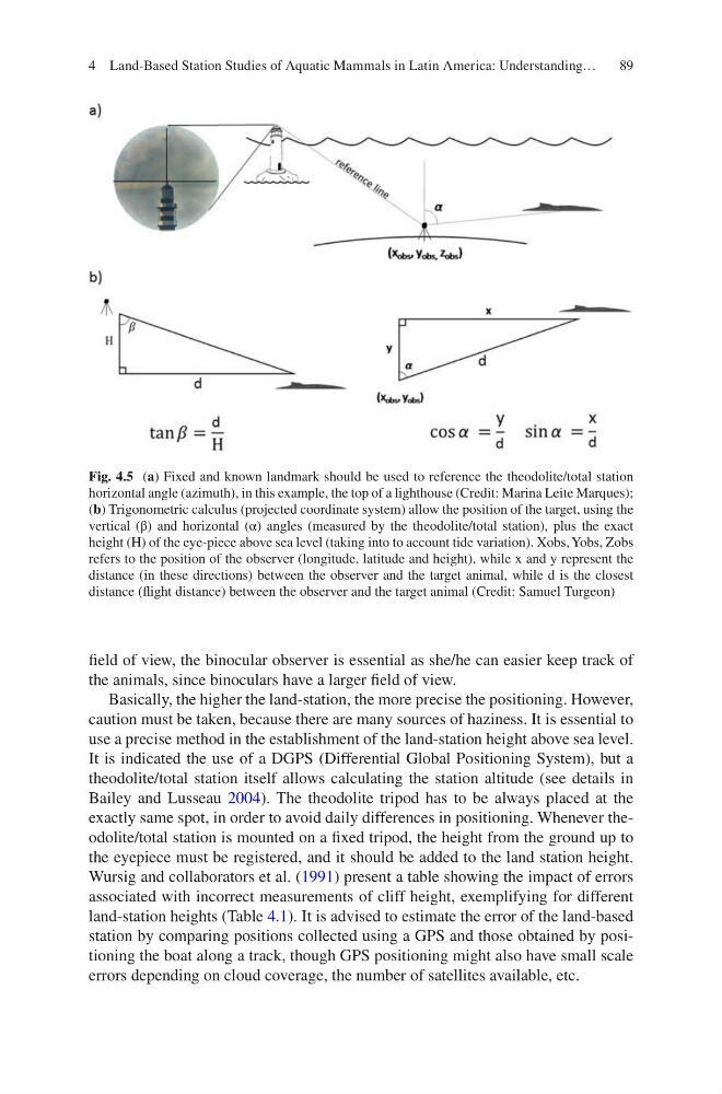
Fig. 4.5 (a) Fixed and known landmark should be used to reference the theodolite/total station
horizontal angle (azimuth), in this example, the top of a lighthouse (Credit: Marina Leite Marques);
(b) Trigonometric calculus (projected coordinate system) allow the position of the target, using the
vertical (β) and horizontal (α) angles (measured by the theodolite/total station), plus the exact
height (H) of the eye-piece above sea level (taking into to account tide variation). Xobs, Yobs, Zobs
refers to the position of the observer (longitude, latitude and height), while x and y represent the
distance (in these directions) between the observer and the target animal, while d is the closest
distance (flight distance) between the observer and the target animal (Credit: Samuel Turgeon)
4 Land-Based Station Studies of Aquatic Mammals in Latin America: Understanding…
field of view, the binocular observer is essential as she/he can easier keep track of
the animals, since binoculars have a larger field of view.
Basically, the higher the land-station, the more precise the positioning. However,
caution must be taken, because there are many sources of haziness. It is essential to
use a precise method in the establishment of the land-station height above sea level.
It is indicated the use of a DGPS (Differential Global Positioning System), but a
theodolite/total station itself allows calculating the station altitude (see details in
Bailey and Lusseau 2004). The theodolite tripod has to be always placed at the
exactly same spot, in order to avoid daily differences in positioning. Whenever theodolite/total station is mounted on a fixed tripod, the height from the ground up to
the eyepiece must be registered, and it should be added to the land station height.
Wursig and collaborators et al. (1991) present a table showing the impact of errors
associated with incorrect measurements of cliff height, exemplifying for different
land-station heights (Table 4.1). It is advised to estimate the error of the land-based
station by comparing positions collected using a GPS and those obtained by positioning the boat along a track, though GPS positioning might also have small scale
errors depending on cloud coverage, the number of satellites available, etc.
Fig. 4.5 (a) Fixed and known landmark should be used to reference the theodolite/total station
horizontal angle (azimuth), in this example, the top of a lighthouse (Credit: Marina Leite Marques);
(b) Trigonometric calculus (projected coordinate system) allow the position of the target, using the
vertical (β) and horizontal (α) angles (measured by the theodolite/total station), plus the exact
height (H) of the eye-piece above sea level (taking into to account tide variation). Xobs, Yobs, Zobs
refers to the position of the observer (longitude, latitude and height), while x and y represent the
distance (in these directions) between the observer and the target animal, while d is the closest
distance (flight distance) between the observer and the target animal (Credit: Samuel Turgeon)
4 Land-Based Station Studies of Aquatic Mammals in Latin America: Understanding…