

174
and one was incidentally capture in a driftnet off the coast of São Paulo State.
Tracking in the breeding area revealed that between successive egg-laying trips, the
turtles spread out and move up to 160 km off the coastline. The post-nesting migrations helped to identify foraging grounds between the South of Brazil and the Rio
de la Plata estuary (Fig. 7.8) (Almeida et al. 2011). The overlap between the highuse areas of these animals and large-scale fishing zones was highlights as a major
threat to these turtles.
7.2.1.1 Conservation Implications
Tracking data has helped us to identify migratory corridors and high-use areas of sea
turtles in Brazilian waters. In addition, these findings were essential to better understand the impacts of human activities- such as fishing- across their habitats to
improve coastal management. It is recognized that satellite telemetry can be a useful
tool in determining the effectiveness of current marine protected areas (MPA) boundaries and where additional protected areas should be considered (Witt et al. 2008,
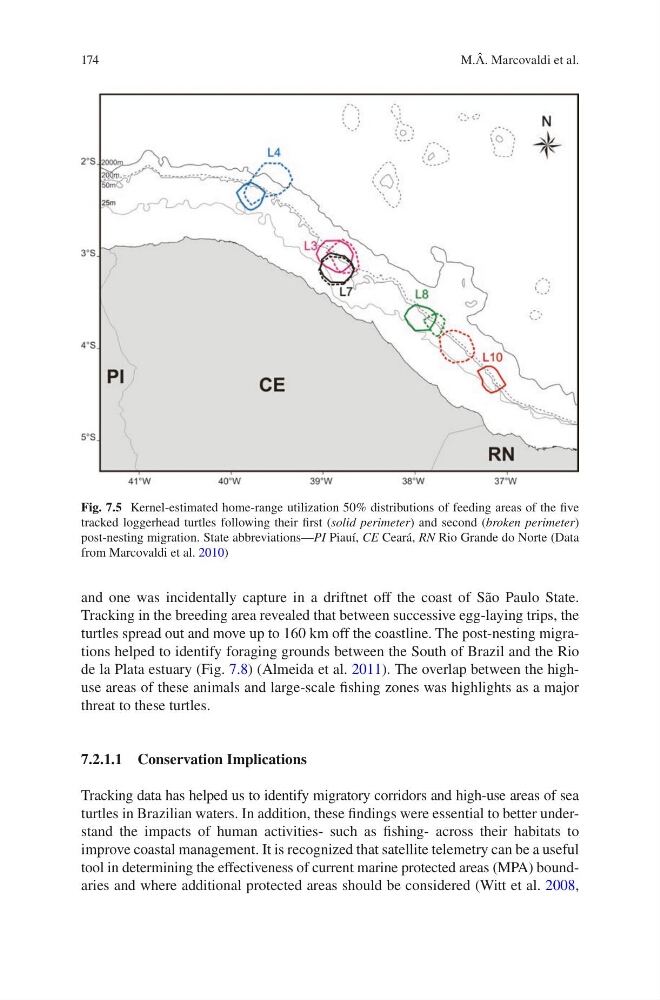
Fig. 7.5 Kernel-estimated home-range utilization 50% distributions of feeding areas of the five
tracked loggerhead turtles following their first (solid perimeter) and second (broken perimeter)
post-nesting migration. State abbreviations—PI Piauí, CE Ceará, RN Rio Grande do Norte (Data
from Marcovaldi et al. 2010)
M.Â. Marcovaldi et al.
and one was incidentally capture in a driftnet off the coast of São Paulo State.
Tracking in the breeding area revealed that between successive egg-laying trips, the
turtles spread out and move up to 160 km off the coastline. The post-nesting migrations helped to identify foraging grounds between the South of Brazil and the Rio
de la Plata estuary (Fig. 7.8) (Almeida et al. 2011). The overlap between the highuse areas of these animals and large-scale fishing zones was highlights as a major
threat to these turtles.
7.2.1.1 Conservation Implications
Tracking data has helped us to identify migratory corridors and high-use areas of sea
turtles in Brazilian waters. In addition, these findings were essential to better understand the impacts of human activities- such as fishing- across their habitats to
improve coastal management. It is recognized that satellite telemetry can be a useful
tool in determining the effectiveness of current marine protected areas (MPA) boundaries and where additional protected areas should be considered (Witt et al. 2008,
Fig. 7.5 Kernel-estimated home-range utilization 50% distributions of feeding areas of the five
tracked loggerhead turtles following their first (solid perimeter) and second (broken perimeter)
post-nesting migration. State abbreviations—PI Piauí, CE Ceará, RN Rio Grande do Norte (Data
from Marcovaldi et al. 2010)
M.Â. Marcovaldi et al.