

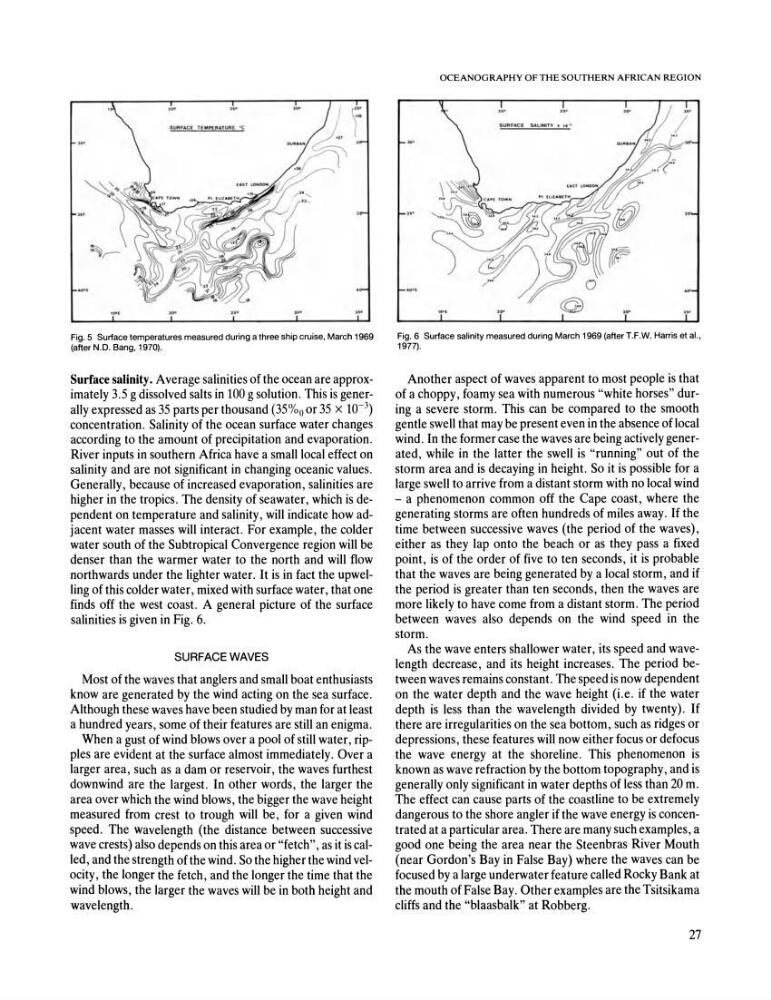
Fig.5 Surface temperatures measured during a three ship cruise, March 1969
(after N.D. Bang, 1970).
Surface salinity • Average salinities of the ocean are approximately 3.5 g dissolved salts in 100 g solution. This is generally expressed as 35 parts per thousand (35%0 or 35 X 10- 3 )
concentration. Salinity of the ocean surface water changes
according to the amount of precipitation and evaporation.
River inputs in southern Africa have a small local effect on
salinity and are not significant in changing oceanic values.
Generally, because of increased evaporation, salinities are
higher in the tropics. The density of seawater, which is dependent on temperature and salinity, will indicate how adjacent water masses will interact. For example, the colder
water south of the Subtropical Convergence region will be
denser than the warmer water to the north and will flow
northwards under the lighter water. It is in fact the upwelling of this colder water, mixed with surface water, that one
finds off the west coast. A general picture of the surface
salinities is given in Fig. 6.
SURFACE WAVES
Most of the waves that anglers and small boat enthusiasts
know are generated by the wind acting on the sea surface.
Although these waves have been studied by man for at least
a hundred years, some of their features are still an enigma.
When a gust of wind blows over a pool of still water, ripples are evident at the surface almost immediately. Over a
larger area, such as a dam or reservoir, the waves furthest
downwind are the largest. In other words, the larger the
area over which the wind blows, the bigger the wave height
measured from crest to trough will be, for a given wind
speed. The wavelength (the distance between successive
wave crests) also depends on this area or "fetch", as it is called, and the strength of the wind. So the higher the wind velocity, the longer the fetch, and the longer the time that the
wind blows, the larger the waves will be in both height and
wavelength.
OCEANOGRAPHY OF THE SOUTHERN AFRICAN REGION
Fig. 6 Surface salinity measured during March 1969 (after T.F.W. Harris et aI.,
1977).
Another aspect of waves apparent to most people is that
of a choppy, foamy sea with numerous "white horses" during a severe storm. This can be compared to the smooth
gentle swell that may be present even in the absence of local
wind. In the former case the waves are being actively generated, while in the latter the swell is "running" out of the
storm area and is decaying in height. So it is possible for a
large swell to arrive from a distant storm with no local wind
- a phenomenon common off the Cape coast, where the
generating storms are often hundreds of miles away. If the
time between successive waves (the period of the waves),
either as they lap onto the beach or as they pass a fixed
point, is of the order of five to ten seconds, it is probable
that the waves are being generated by a local storm, and if
the period is greater than ten seconds, then the waves are
more likely to have come from a distant storm. The period
between waves also depends on the wind speed in the
storm.
As the wave enters shallower water, its speed and wavelength decrease, and its height increases. The period between waves remains constant. The speed is now dependent
on the water depth and the wave height (i.e. if the water
depth is less than the wavelength divided by twenty). If
there are irregularities on the sea bottom, such as ridges or
depressions, these features will now either focus or defocus
the wave energy at the shoreline. This phenomenon is
known as wave refraction by the bottom topography, and is
generally only significant in water depths of less than 20 m.
The effect can cause parts of the coastline to be extremely
dangerous to the shore angler if the wave energy is concentrated at a particular area. There are many such examples, a
good one being the area near the Steen bras River Mouth
(near Gordon's Bay in False Bay) where the waves can be
focused by a large underwater feature called Rocky Bank at
the mouth of False Bay. Other examples are the Tsitsikama
cliffs and the "blaasbalk" at Robberg.
27
(after N.D. Bang, 1970).
Surface salinity • Average salinities of the ocean are approximately 3.5 g dissolved salts in 100 g solution. This is generally expressed as 35 parts per thousand (35%0 or 35 X 10- 3 )
concentration. Salinity of the ocean surface water changes
according to the amount of precipitation and evaporation.
River inputs in southern Africa have a small local effect on
salinity and are not significant in changing oceanic values.
Generally, because of increased evaporation, salinities are
higher in the tropics. The density of seawater, which is dependent on temperature and salinity, will indicate how adjacent water masses will interact. For example, the colder
water south of the Subtropical Convergence region will be
denser than the warmer water to the north and will flow
northwards under the lighter water. It is in fact the upwelling of this colder water, mixed with surface water, that one
finds off the west coast. A general picture of the surface
salinities is given in Fig. 6.
SURFACE WAVES
Most of the waves that anglers and small boat enthusiasts
know are generated by the wind acting on the sea surface.
Although these waves have been studied by man for at least
a hundred years, some of their features are still an enigma.
When a gust of wind blows over a pool of still water, ripples are evident at the surface almost immediately. Over a
larger area, such as a dam or reservoir, the waves furthest
downwind are the largest. In other words, the larger the
area over which the wind blows, the bigger the wave height
measured from crest to trough will be, for a given wind
speed. The wavelength (the distance between successive
wave crests) also depends on this area or "fetch", as it is called, and the strength of the wind. So the higher the wind velocity, the longer the fetch, and the longer the time that the
wind blows, the larger the waves will be in both height and
wavelength.
OCEANOGRAPHY OF THE SOUTHERN AFRICAN REGION
Fig. 6 Surface salinity measured during March 1969 (after T.F.W. Harris et aI.,
1977).
Another aspect of waves apparent to most people is that
of a choppy, foamy sea with numerous "white horses" during a severe storm. This can be compared to the smooth
gentle swell that may be present even in the absence of local
wind. In the former case the waves are being actively generated, while in the latter the swell is "running" out of the
storm area and is decaying in height. So it is possible for a
large swell to arrive from a distant storm with no local wind
- a phenomenon common off the Cape coast, where the
generating storms are often hundreds of miles away. If the
time between successive waves (the period of the waves),
either as they lap onto the beach or as they pass a fixed
point, is of the order of five to ten seconds, it is probable
that the waves are being generated by a local storm, and if
the period is greater than ten seconds, then the waves are
more likely to have come from a distant storm. The period
between waves also depends on the wind speed in the
storm.
As the wave enters shallower water, its speed and wavelength decrease, and its height increases. The period between waves remains constant. The speed is now dependent
on the water depth and the wave height (i.e. if the water
depth is less than the wavelength divided by twenty). If
there are irregularities on the sea bottom, such as ridges or
depressions, these features will now either focus or defocus
the wave energy at the shoreline. This phenomenon is
known as wave refraction by the bottom topography, and is
generally only significant in water depths of less than 20 m.
The effect can cause parts of the coastline to be extremely
dangerous to the shore angler if the wave energy is concentrated at a particular area. There are many such examples, a
good one being the area near the Steen bras River Mouth
(near Gordon's Bay in False Bay) where the waves can be
focused by a large underwater feature called Rocky Bank at
the mouth of False Bay. Other examples are the Tsitsikama
cliffs and the "blaasbalk" at Robberg.
27