

Panama: Bastimentos Island National Marine Park, Portobelo, Soberania, Galeta,
Chagres, and the wetlands of San San Pond Sank (Gómez et al. 2005).
The Pacific coast of Panama is comprised of two gulfs; the Gulf of Chiriquí and
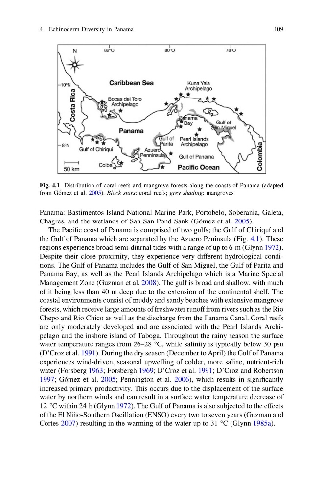
the Gulf of Panama which are separated by the Azuero Peninsula (Fig. 4.1). These
regions experience broad semi-diurnal tides with a range of up to 6 m (Glynn 1972).
Despite their close proximity, they experience very different hydrological conditions. The Gulf of Panama includes the Gulf of San Miguel, the Gulf of Parita and
Panama Bay, as well as the Pearl Islands Archipelago which is a Marine Special
Management Zone (Guzman et al. 2008). The gulf is broad and shallow, with much
of it being less than 40 m deep due to the extension of the continental shelf. The
coastal environments consist of muddy and sandy beaches with extensive mangrove
forests, which receive large amounts of freshwater runoff from rivers such as the Rio
Chepo and Rio Chico as well as the discharge from the Panama Canal. Coral reefs
are only moderately developed and are associated with the Pearl Islands Archipelago and the inshore island of Taboga. Throughout the rainy season the surface
water temperature ranges from 26–28 °C, while salinity is typically below 30 psu
(D’Croz et al. 1991). During the dry season (December to April) the Gulf of Panama
experiences wind-driven, seasonal upwelling of colder, more saline, nutrient-rich
water (Forsberg 1963; Forsbergh 1969; D’Croz et al. 1991; D’Croz and Robertson
1997; Gómez et al. 2005; Pennington et al. 2006), which results in significantly
increased primary productivity. This occurs due to the displacement of the surface
water by northern winds and can result in a surface water temperature decrease of
12 °C within 24 h (Glynn 1972). The Gulf of Panama is also subjected to the effects
of the El Niño-Southern Oscillation (ENSO) every two to seven years (Guzman and
Cortes 2007) resulting in the warming of the water up to 31 °C (Glynn 1985a).
Fig. 4.1 Distribution of coral reefs and mangrove forests along the coasts of Panama (adapted
from Gómez et al. 2005). Black stars: coral reefs; grey shading: mangroves
4 Echinoderm Diversity in Panama
109
Chagres, and the wetlands of San San Pond Sank (Gómez et al. 2005).
The Pacific coast of Panama is comprised of two gulfs; the Gulf of Chiriquí and
the Gulf of Panama which are separated by the Azuero Peninsula (Fig. 4.1). These
regions experience broad semi-diurnal tides with a range of up to 6 m (Glynn 1972).
Despite their close proximity, they experience very different hydrological conditions. The Gulf of Panama includes the Gulf of San Miguel, the Gulf of Parita and
Panama Bay, as well as the Pearl Islands Archipelago which is a Marine Special
Management Zone (Guzman et al. 2008). The gulf is broad and shallow, with much
of it being less than 40 m deep due to the extension of the continental shelf. The
coastal environments consist of muddy and sandy beaches with extensive mangrove
forests, which receive large amounts of freshwater runoff from rivers such as the Rio
Chepo and Rio Chico as well as the discharge from the Panama Canal. Coral reefs
are only moderately developed and are associated with the Pearl Islands Archipelago and the inshore island of Taboga. Throughout the rainy season the surface
water temperature ranges from 26–28 °C, while salinity is typically below 30 psu
(D’Croz et al. 1991). During the dry season (December to April) the Gulf of Panama
experiences wind-driven, seasonal upwelling of colder, more saline, nutrient-rich
water (Forsberg 1963; Forsbergh 1969; D’Croz et al. 1991; D’Croz and Robertson
1997; Gómez et al. 2005; Pennington et al. 2006), which results in significantly
increased primary productivity. This occurs due to the displacement of the surface
water by northern winds and can result in a surface water temperature decrease of
12 °C within 24 h (Glynn 1972). The Gulf of Panama is also subjected to the effects
of the El Niño-Southern Oscillation (ENSO) every two to seven years (Guzman and
Cortes 2007) resulting in the warming of the water up to 31 °C (Glynn 1985a).
Fig. 4.1 Distribution of coral reefs and mangrove forests along the coasts of Panama (adapted
from Gómez et al. 2005). Black stars: coral reefs; grey shading: mangroves
4 Echinoderm Diversity in Panama
109