

80
G. Lericolais
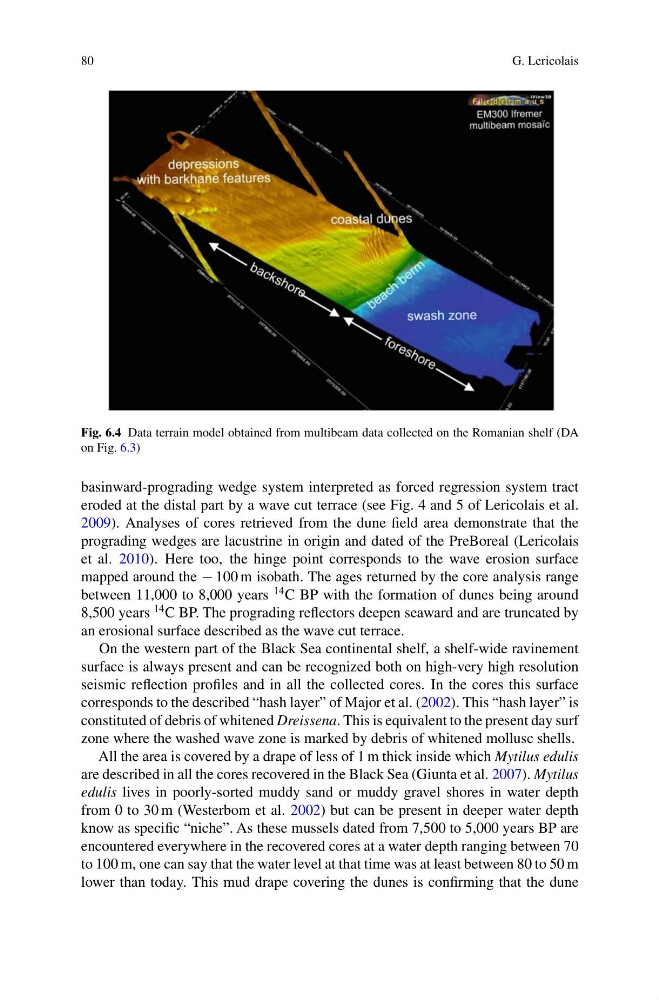
Fig. 6.4 Data terrain model obtained from multibeam data collected on the Romanian shelf (DA
on Fig. 6.3)
basinward-prograding wedge system interpreted as forced regression system tract
eroded at the distal part by a wave cut terrace (see Fig. 4 and 5 of Lericolais et al.
2009). Analyses of cores retrieved from the dune field area demonstrate that the
prograding wedges are lacustrine in origin and dated of the PreBoreal (Lericolais
et al. 2010). Here too, the hinge point corresponds to the wave erosion surface
mapped around the − 100 m isobath. The ages returned by the core analysis range
between 11,000 to 8,000 years
14 C BP with the formation of dunes being around
8,500 years
14 C BP. The prograding reflectors deepen seaward and are truncated by
an erosional surface described as the wave cut terrace.
On the western part of the Black Sea continental shelf, a shelf-wide ravinement
surface is always present and can be recognized both on high-very high resolution
seismic reflection profiles and in all the collected cores. In the cores this surface
corresponds to the described “hash layer” of Major et al. (2002). This “hash layer” is
constituted of debris of whitened Dreissena. This is equivalent to the present day surf
zone where the washed wave zone is marked by debris of whitened mollusc shells.
All the area is covered by a drape of less of 1 m thick inside which Mytilus edulis
are described in all the cores recovered in the Black Sea (Giunta et al. 2007). Mytilus
edulis lives in poorly-sorted muddy sand or muddy gravel shores in water depth
from 0 to 30 m (Westerbom et al. 2002) but can be present in deeper water depth
know as specific “niche”. As these mussels dated from 7,500 to 5,000 years BP are
encountered everywhere in the recovered cores at a water depth ranging between 70
to 100 m, one can say that the water level at that time was at least between 80 to 50 m
lower than today. This mud drape covering the dunes is confirming that the dune
G. Lericolais
Fig. 6.4 Data terrain model obtained from multibeam data collected on the Romanian shelf (DA
on Fig. 6.3)
basinward-prograding wedge system interpreted as forced regression system tract
eroded at the distal part by a wave cut terrace (see Fig. 4 and 5 of Lericolais et al.
2009). Analyses of cores retrieved from the dune field area demonstrate that the
prograding wedges are lacustrine in origin and dated of the PreBoreal (Lericolais
et al. 2010). Here too, the hinge point corresponds to the wave erosion surface
mapped around the − 100 m isobath. The ages returned by the core analysis range
between 11,000 to 8,000 years
14 C BP with the formation of dunes being around
8,500 years
14 C BP. The prograding reflectors deepen seaward and are truncated by
an erosional surface described as the wave cut terrace.
On the western part of the Black Sea continental shelf, a shelf-wide ravinement
surface is always present and can be recognized both on high-very high resolution
seismic reflection profiles and in all the collected cores. In the cores this surface
corresponds to the described “hash layer” of Major et al. (2002). This “hash layer” is
constituted of debris of whitened Dreissena. This is equivalent to the present day surf
zone where the washed wave zone is marked by debris of whitened mollusc shells.
All the area is covered by a drape of less of 1 m thick inside which Mytilus edulis
are described in all the cores recovered in the Black Sea (Giunta et al. 2007). Mytilus
edulis lives in poorly-sorted muddy sand or muddy gravel shores in water depth
from 0 to 30 m (Westerbom et al. 2002) but can be present in deeper water depth
know as specific “niche”. As these mussels dated from 7,500 to 5,000 years BP are
encountered everywhere in the recovered cores at a water depth ranging between 70
to 100 m, one can say that the water level at that time was at least between 80 to 50 m
lower than today. This mud drape covering the dunes is confirming that the dune