

10 The Concept of Marine Landscapes Within the French Information System . . .
159
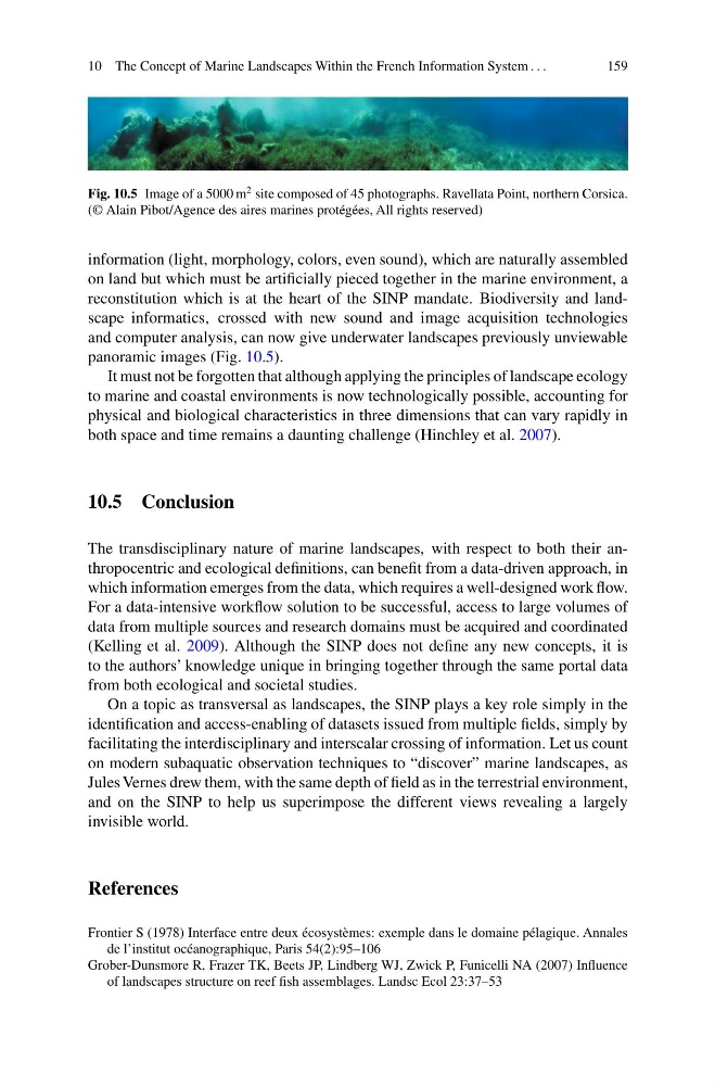
Fig. 10.5 Image of a 5000 m
2 site composed of 45 photographs. Ravellata Point, northern Corsica.
(© Alain Pibot/Agence des aires marines protégées, All rights reserved)
information (light, morphology, colors, even sound), which are naturally assembled
on land but which must be artificially pieced together in the marine environment, a
reconstitution which is at the heart of the SINP mandate. Biodiversity and landscape informatics, crossed with new sound and image acquisition technologies
and computer analysis, can now give underwater landscapes previously unviewable
panoramic images (Fig. 10.5).
It must not be forgotten that although applying the principles of landscape ecology
to marine and coastal environments is now technologically possible, accounting for
physical and biological characteristics in three dimensions that can vary rapidly in
both space and time remains a daunting challenge (Hinchley et al. 2007).
10.5 Conclusion
The transdisciplinary nature of marine landscapes, with respect to both their anthropocentric and ecological definitions, can benefit from a data-driven approach, in
which information emerges from the data, which requires a well-designed work flow.
For a data-intensive workflow solution to be successful, access to large volumes of
data from multiple sources and research domains must be acquired and coordinated
(Kelling et al. 2009). Although the SINP does not define any new concepts, it is
to the authors’ knowledge unique in bringing together through the same portal data
from both ecological and societal studies.
On a topic as transversal as landscapes, the SINP plays a key role simply in the
identification and access-enabling of datasets issued from multiple fields, simply by
facilitating the interdisciplinary and interscalar crossing of information. Let us count
on modern subaquatic observation techniques to “discover” marine landscapes, as
Jules Vernes drew them, with the same depth of field as in the terrestrial environment,
and on the SINP to help us superimpose the different views revealing a largely
invisible world.
References
Frontier S (1978) Interface entre deux écosystèmes: exemple dans le domaine pélagique. Annales
de l’institut océanographique, Paris 54(2):95–106
Grober-Dunsmore R, Frazer TK, Beets JP, Lindberg WJ, Zwick P, Funicelli NA (2007) Influence
of landscapes structure on reef fish assemblages. Landsc Ecol 23:37–53
159
Fig. 10.5 Image of a 5000 m
2 site composed of 45 photographs. Ravellata Point, northern Corsica.
(© Alain Pibot/Agence des aires marines protégées, All rights reserved)
information (light, morphology, colors, even sound), which are naturally assembled
on land but which must be artificially pieced together in the marine environment, a
reconstitution which is at the heart of the SINP mandate. Biodiversity and landscape informatics, crossed with new sound and image acquisition technologies
and computer analysis, can now give underwater landscapes previously unviewable
panoramic images (Fig. 10.5).
It must not be forgotten that although applying the principles of landscape ecology
to marine and coastal environments is now technologically possible, accounting for
physical and biological characteristics in three dimensions that can vary rapidly in
both space and time remains a daunting challenge (Hinchley et al. 2007).
10.5 Conclusion
The transdisciplinary nature of marine landscapes, with respect to both their anthropocentric and ecological definitions, can benefit from a data-driven approach, in
which information emerges from the data, which requires a well-designed work flow.
For a data-intensive workflow solution to be successful, access to large volumes of
data from multiple sources and research domains must be acquired and coordinated
(Kelling et al. 2009). Although the SINP does not define any new concepts, it is
to the authors’ knowledge unique in bringing together through the same portal data
from both ecological and societal studies.
On a topic as transversal as landscapes, the SINP plays a key role simply in the
identification and access-enabling of datasets issued from multiple fields, simply by
facilitating the interdisciplinary and interscalar crossing of information. Let us count
on modern subaquatic observation techniques to “discover” marine landscapes, as
Jules Vernes drew them, with the same depth of field as in the terrestrial environment,
and on the SINP to help us superimpose the different views revealing a largely
invisible world.
References
Frontier S (1978) Interface entre deux écosystèmes: exemple dans le domaine pélagique. Annales
de l’institut océanographique, Paris 54(2):95–106
Grober-Dunsmore R, Frazer TK, Beets JP, Lindberg WJ, Zwick P, Funicelli NA (2007) Influence
of landscapes structure on reef fish assemblages. Landsc Ecol 23:37–53