

asymmetrically prograded platform and a uniformly
eroded nearshore rock ledge.
Seismic profiles show the presence of a discontinuous
$27-m-deep Pleistocene trough behind the discontinuous
shelf-edge reef. Where present, the trough along much of
the >200-km-long margin has been filled with
landward-transported, storm-derived Holocene sand and
reef rubble that, in scattered locations, is topped by skeletal Holocene reefs. Most surface traces of the trough have
been obliterated, and infilling has forced progradation
of those isolated parts of the shelf surface seaward.
Infilling and progradational processes were rapid relative
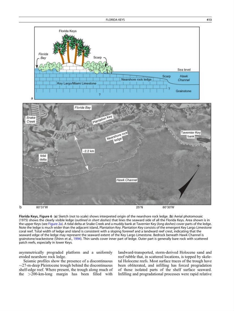
Florida Keys, Figure 6 (a) Sketch (not to scale) shows interpreted origin of the nearshore rock ledge. (b) Aerial photomosaic
(1975) shows the clearly visible ledge (outlined in short dashes) that lines the seaward side of all the Florida Keys. Area shown is in
the upper Keys (see Figure 2a). A tidal delta at Snake Creek and a muddy bank at Tavernier Key (long dashes) cover parts of the ledge.
Note the ledge is much wider than the adjacent island, Plantation Key. Plantation Key consists of the emergent Key Largo Limestone
coral reef. Total width of ledge and island is consistent with a sloping forereef and a landward reef crest, indicating that the
seaward edge of the ledge may represent the seaward extent of the Key Largo Limestone. Bedrock beneath Hawk Channel is
grainstone/wackestone (Shinn et al., 1994). Thin sands cover inner part of ledge. Outer part is generally bare rock with scattered
patch reefs, especially in lower Keys.
FLORIDA KEYS
413
eroded nearshore rock ledge.
Seismic profiles show the presence of a discontinuous
$27-m-deep Pleistocene trough behind the discontinuous
shelf-edge reef. Where present, the trough along much of
the >200-km-long margin has been filled with
landward-transported, storm-derived Holocene sand and
reef rubble that, in scattered locations, is topped by skeletal Holocene reefs. Most surface traces of the trough have
been obliterated, and infilling has forced progradation
of those isolated parts of the shelf surface seaward.
Infilling and progradational processes were rapid relative
Florida Keys, Figure 6 (a) Sketch (not to scale) shows interpreted origin of the nearshore rock ledge. (b) Aerial photomosaic
(1975) shows the clearly visible ledge (outlined in short dashes) that lines the seaward side of all the Florida Keys. Area shown is in
the upper Keys (see Figure 2a). A tidal delta at Snake Creek and a muddy bank at Tavernier Key (long dashes) cover parts of the ledge.
Note the ledge is much wider than the adjacent island, Plantation Key. Plantation Key consists of the emergent Key Largo Limestone
coral reef. Total width of ledge and island is consistent with a sloping forereef and a landward reef crest, indicating that the
seaward edge of the ledge may represent the seaward extent of the Key Largo Limestone. Bedrock beneath Hawk Channel is
grainstone/wackestone (Shinn et al., 1994). Thin sands cover inner part of ledge. Outer part is generally bare rock with scattered
patch reefs, especially in lower Keys.
FLORIDA KEYS
413