

purely elastic, then over the entire cycle, the coseismic
deformation would remove all of the elastic deformation
accumulated during the interseismic period. However, in
reality, this seldom is the case because usually there is
some long-term permanent tectonic deformation over the
course of an earthquake cycle (e.g., Taylor et al., 1987;
Briggs et al., 2008).
Methods to measure coseismic coral reef
emergence
Precise systematic measurements of uplift, as well as subsidence, should be conducted soon after reefs are affected
by earthquakes. Immediately following coseismic displacement post-seismic visco-elastic adjustments often
rapidly modify the original coseismic deformation pattern.
If one can measure the geography of coseismic vertical
deformation soon after an earthquake, then later measurements may reveal the geographic pattern and rates of postseismic vertical deformation.
Measurements of coseismic uplift and subsidence typically are based on the heights of corals killed by emergence relative to mean low-water (tide) level, or some
other datum related to their normal shallowest depth. Taylor et al. (1987) called the shallowest level that a coral
could live and grow as its “highest level of survival
(HLS),” a term since adopted by other workers (e.g.,
Zachariasen et al., 1999; Meltzner et al., 2006).
Although other reef organisms such as coralline algae
also can be used to measure uplift (e.g., Pelletier et al.,
2000), corals are believed to define emergence to within
a few cm (e.g., Briggs et al., 2006). Taylor et al. (1980) initiated the practice of measuring the height of numerous
emerged corals of a given species relative to nearby stillliving corals of the same species, thus obviating the need
to establish a tidal datum for each measurement locality.
The HLS for head coral-genera such as Porites and
Goniastrea have different relationships to sea level so that
comparing the height of one genus or species to another
would be likely to introduce errors. An inexpensive auto
level, tripod, and rod enable quite precise measurements
between numerous living and emerged corals.
In a few cases, GPS survey marks have been emplaced
prior to coseismic reef displacement and then re-measured
after an event (e.g., Subarya et al., 2006). The precision for
GPS measurements of vertical displacement is on the
order of 2 cm. A limitation of GPS is that few points have
been measured and even when many more exist, coral
methods probably will remain important for areas where
there are no GPS measurements.
Meltzner et al. (2006) used satellite observations to estimate vertical reef displacements by observing the pinkish to
red false color on ASTER, QuickBird, and other satellite
images of the December 2004 Sumatra-Andamans event.
These colors indicate emerged coral overgrown by algae,
which occurs within days after a coral dies from emergence.
They compared pre- and post-seismic images and used
a tide model to estimate the tide levels at the time when each
photograph was taken. Several studies have used before and
after Synthetic Aperture Radar (SAR) satellite images to
estimate the amounts of coseismic vertical displacement
(e.g., Tobita et al., 2006; Lubis and Isezaki, 2008).
Fieldwork in the Mentawai Islands off Sumatra has led
to refinement of techniques and the term “coral geodesy”
or “paleo-geodesy” to describe the use of corals to document past vertical tectonic motions (Zachariasen et al.,
1999, 2000; Sieh et al., 1999; Briggs et al., 2006; Meltzner
et al., 2006; Natawidjaja et al., 2006, 2007; Sieh et al.,
2008). Micro atolls can record the details of coseismic
and interseismic vertical motions over many decades.
Annual density bands within coral heads can reveal the
timing of relative sea-level changes and the absolute age
can be determined using Uranium-series dates (Figure 4).
Recognition of coseismically emerged reefs
Scientists are unlikely to actually witness coseismic vertical displacment and thus the coseismic relationship to displacements generally depends on the testimony of
witnesses. However, local observers may not notice small
vertical movements or they may have occurred in the past
when there was no oral or written record of the uplift or an
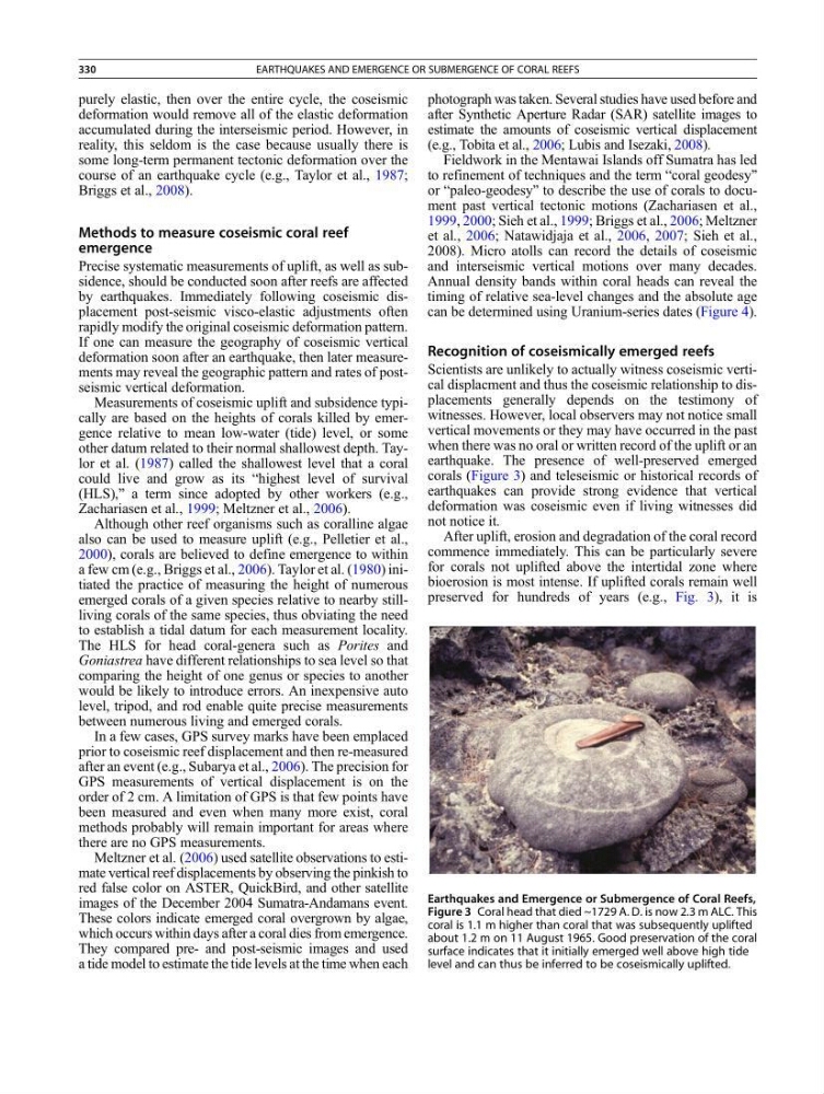
earthquake. The presence of well-preserved emerged
corals (Figure 3) and teleseismic or historical records of
earthquakes can provide strong evidence that vertical
deformation was coseismic even if living witnesses did
not notice it.
After uplift, erosion and degradation of the coral record
commence immediately. This can be particularly severe
for corals not uplifted above the intertidal zone where
bioerosion is most intense. If uplifted corals remain well
preserved for hundreds of years (e.g., Fig. 3), it is
Earthquakes and Emergence or Submergence of Coral Reefs,
Figure 3 Coral head that died ~1729 A. D. is now 2.3 m ALC. This
coral is 1.1 m higher than coral that was subsequently uplifted
about 1.2 m on 11 August 1965. Good preservation of the coral
surface indicates that it initially emerged well above high tide
level and can thus be inferred to be coseismically uplifted.
330
EARTHQUAKES AND EMERGENCE OR SUBMERGENCE OF CORAL REEFS
deformation would remove all of the elastic deformation
accumulated during the interseismic period. However, in
reality, this seldom is the case because usually there is
some long-term permanent tectonic deformation over the
course of an earthquake cycle (e.g., Taylor et al., 1987;
Briggs et al., 2008).
Methods to measure coseismic coral reef
emergence
Precise systematic measurements of uplift, as well as subsidence, should be conducted soon after reefs are affected
by earthquakes. Immediately following coseismic displacement post-seismic visco-elastic adjustments often
rapidly modify the original coseismic deformation pattern.
If one can measure the geography of coseismic vertical
deformation soon after an earthquake, then later measurements may reveal the geographic pattern and rates of postseismic vertical deformation.
Measurements of coseismic uplift and subsidence typically are based on the heights of corals killed by emergence relative to mean low-water (tide) level, or some
other datum related to their normal shallowest depth. Taylor et al. (1987) called the shallowest level that a coral
could live and grow as its “highest level of survival
(HLS),” a term since adopted by other workers (e.g.,
Zachariasen et al., 1999; Meltzner et al., 2006).
Although other reef organisms such as coralline algae
also can be used to measure uplift (e.g., Pelletier et al.,
2000), corals are believed to define emergence to within
a few cm (e.g., Briggs et al., 2006). Taylor et al. (1980) initiated the practice of measuring the height of numerous
emerged corals of a given species relative to nearby stillliving corals of the same species, thus obviating the need
to establish a tidal datum for each measurement locality.
The HLS for head coral-genera such as Porites and
Goniastrea have different relationships to sea level so that
comparing the height of one genus or species to another
would be likely to introduce errors. An inexpensive auto
level, tripod, and rod enable quite precise measurements
between numerous living and emerged corals.
In a few cases, GPS survey marks have been emplaced
prior to coseismic reef displacement and then re-measured
after an event (e.g., Subarya et al., 2006). The precision for
GPS measurements of vertical displacement is on the
order of 2 cm. A limitation of GPS is that few points have
been measured and even when many more exist, coral
methods probably will remain important for areas where
there are no GPS measurements.
Meltzner et al. (2006) used satellite observations to estimate vertical reef displacements by observing the pinkish to
red false color on ASTER, QuickBird, and other satellite
images of the December 2004 Sumatra-Andamans event.
These colors indicate emerged coral overgrown by algae,
which occurs within days after a coral dies from emergence.
They compared pre- and post-seismic images and used
a tide model to estimate the tide levels at the time when each
photograph was taken. Several studies have used before and
after Synthetic Aperture Radar (SAR) satellite images to
estimate the amounts of coseismic vertical displacement
(e.g., Tobita et al., 2006; Lubis and Isezaki, 2008).
Fieldwork in the Mentawai Islands off Sumatra has led
to refinement of techniques and the term “coral geodesy”
or “paleo-geodesy” to describe the use of corals to document past vertical tectonic motions (Zachariasen et al.,
1999, 2000; Sieh et al., 1999; Briggs et al., 2006; Meltzner
et al., 2006; Natawidjaja et al., 2006, 2007; Sieh et al.,
2008). Micro atolls can record the details of coseismic
and interseismic vertical motions over many decades.
Annual density bands within coral heads can reveal the
timing of relative sea-level changes and the absolute age
can be determined using Uranium-series dates (Figure 4).
Recognition of coseismically emerged reefs
Scientists are unlikely to actually witness coseismic vertical displacment and thus the coseismic relationship to displacements generally depends on the testimony of
witnesses. However, local observers may not notice small
vertical movements or they may have occurred in the past
when there was no oral or written record of the uplift or an
earthquake. The presence of well-preserved emerged
corals (Figure 3) and teleseismic or historical records of
earthquakes can provide strong evidence that vertical
deformation was coseismic even if living witnesses did
not notice it.
After uplift, erosion and degradation of the coral record
commence immediately. This can be particularly severe
for corals not uplifted above the intertidal zone where
bioerosion is most intense. If uplifted corals remain well
preserved for hundreds of years (e.g., Fig. 3), it is
Earthquakes and Emergence or Submergence of Coral Reefs,
Figure 3 Coral head that died ~1729 A. D. is now 2.3 m ALC. This
coral is 1.1 m higher than coral that was subsequently uplifted
about 1.2 m on 11 August 1965. Good preservation of the coral
surface indicates that it initially emerged well above high tide
level and can thus be inferred to be coseismically uplifted.
330
EARTHQUAKES AND EMERGENCE OR SUBMERGENCE OF CORAL REEFS