

sediment from the reef flat under the influences of the
winter south-easterlies. However, this cay is close to
the reef edge and a circulatory movement of sediment
around the island does produce a small net loss of sand
of about 20,000 m
3
, equivalent to about 1% of the
island volume (Hopley and Rasmussen, 1998).
Cays of the Maldives are also under strong monsoonal influence with large gross changes (31–21%
of beach area) in shoreline position between seasons,
reflecting significant reversals in sediment flux
of 9–23 Â 10
3 m
3 biannually (Kench and Brander,
2006). However, annual net change is small (2–15%)
indicating the island is in dynamic equilibrium.
(c) Decadal changes
Longer term surveys from aerial photography and
ground truthing can determine if there is a long-term
trend in cay changes and the dimensions of these
changes. On Raine Island (northern GBR), Gourlay
and Hacker (1991) reported erosion of up to 20 m
and accretion of up to 40 m between 1967 and 1990
at specific points around the shore as the cay became
more elongate. Annual sand movement on this small
vegetated cay was about 5,000 m
3 . On Warraber in
Torres Strait, maximum net shoreline movements over
a 20-year period were around 60 m and at Green
Island near Cairns, about 50 m between 1945 and
1978 (see Hopley, 1982). In the Bunker-Capricorn
Islands, Flood (1988) measured average shoreline
movements of between 14 and 53 m between 1972
and 1986 with maximum changes of up to 116 m.
These decadal changes include responses to specific cyclonic events, but also reflect long-term variations to weather patterns. In Torres Strait, wind
records between 1951 and 1992 show a statistically
significant increase in winter winds from the southeast, and an increase in wind speed at about 1975–
1977. Realignment and a change in shape has
occurred on some cays. Similar changes took place
in the Bunker-Capricorn Islands. Here the annual
wind energy vector has oscillated within a 45
arc from
south-south-east in the early 1960s to east-south-east
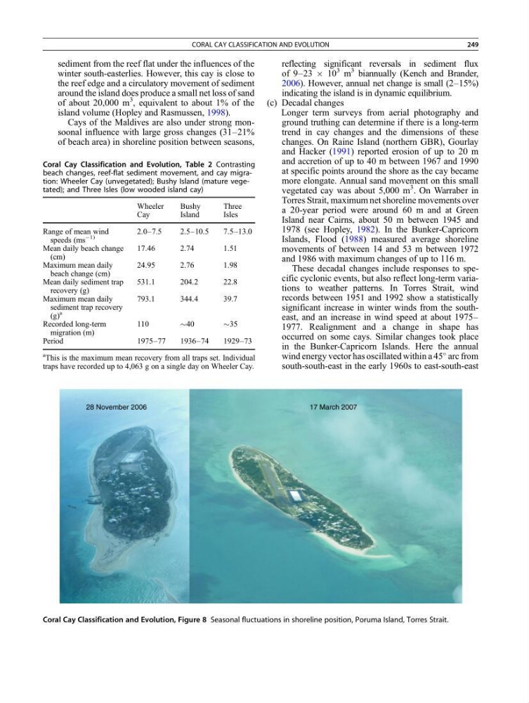
Coral Cay Classification and Evolution, Figure 8 Seasonal fluctuations in shoreline position, Poruma Island, Torres Strait.
Coral Cay Classification and Evolution, Table 2 Contrasting
beach changes, reef-flat sediment movement, and cay migration: Wheeler Cay (unvegetated); Bushy Island (mature vegetated); and Three Isles (low wooded island cay)
Wheeler
Cay
Bushy
Island
Three
Isles
Range of mean wind
speeds (ms
À1)
2.0–7.5
2.5–10.5
7.5–13.0
Mean daily beach change
(cm)
17.46
2.74
1.51
Maximum mean daily
beach change (cm)
24.95
2.76
1.98
Mean daily sediment trap
recovery (g)
531.1
204.2
22.8
Maximum mean daily
sediment trap recovery
(g)
a
793.1
344.4
39.7
Recorded long-term
migration (m)
110
$40
$35
Period
1975–77
1936–74
1929–73
a This is the maximum mean recovery from all traps set. Individual
traps have recorded up to 4,063 g on a single day on Wheeler Cay.
CORAL CAY CLASSIFICATION AND EVOLUTION
249
winter south-easterlies. However, this cay is close to
the reef edge and a circulatory movement of sediment
around the island does produce a small net loss of sand
of about 20,000 m
3
, equivalent to about 1% of the
island volume (Hopley and Rasmussen, 1998).
Cays of the Maldives are also under strong monsoonal influence with large gross changes (31–21%
of beach area) in shoreline position between seasons,
reflecting significant reversals in sediment flux
of 9–23 Â 10
3 m
3 biannually (Kench and Brander,
2006). However, annual net change is small (2–15%)
indicating the island is in dynamic equilibrium.
(c) Decadal changes
Longer term surveys from aerial photography and
ground truthing can determine if there is a long-term
trend in cay changes and the dimensions of these
changes. On Raine Island (northern GBR), Gourlay
and Hacker (1991) reported erosion of up to 20 m
and accretion of up to 40 m between 1967 and 1990
at specific points around the shore as the cay became
more elongate. Annual sand movement on this small
vegetated cay was about 5,000 m
3 . On Warraber in
Torres Strait, maximum net shoreline movements over
a 20-year period were around 60 m and at Green
Island near Cairns, about 50 m between 1945 and
1978 (see Hopley, 1982). In the Bunker-Capricorn
Islands, Flood (1988) measured average shoreline
movements of between 14 and 53 m between 1972
and 1986 with maximum changes of up to 116 m.
These decadal changes include responses to specific cyclonic events, but also reflect long-term variations to weather patterns. In Torres Strait, wind
records between 1951 and 1992 show a statistically
significant increase in winter winds from the southeast, and an increase in wind speed at about 1975–
1977. Realignment and a change in shape has
occurred on some cays. Similar changes took place
in the Bunker-Capricorn Islands. Here the annual
wind energy vector has oscillated within a 45
arc from
south-south-east in the early 1960s to east-south-east
Coral Cay Classification and Evolution, Figure 8 Seasonal fluctuations in shoreline position, Poruma Island, Torres Strait.
Coral Cay Classification and Evolution, Table 2 Contrasting
beach changes, reef-flat sediment movement, and cay migration: Wheeler Cay (unvegetated); Bushy Island (mature vegetated); and Three Isles (low wooded island cay)
Wheeler
Cay
Bushy
Island
Three
Isles
Range of mean wind
speeds (ms
À1)
2.0–7.5
2.5–10.5
7.5–13.0
Mean daily beach change
(cm)
17.46
2.74
1.51
Maximum mean daily
beach change (cm)
24.95
2.76
1.98
Mean daily sediment trap
recovery (g)
531.1
204.2
22.8
Maximum mean daily
sediment trap recovery
(g)
a
793.1
344.4
39.7
Recorded long-term
migration (m)
110
$40
$35
Period
1975–77
1936–74
1929–73
a This is the maximum mean recovery from all traps set. Individual
traps have recorded up to 4,063 g on a single day on Wheeler Cay.
CORAL CAY CLASSIFICATION AND EVOLUTION
249