

BELIZE BARRIER AND ATOLL REEFS
Eberhard Gischler
Goethe-Universität, Frankfurt a.M., Germany
Definition
The Belize barrier and atoll reefs form the largest modern
reef system in the Atlantic Ocean. Belize, formerly British
Honduras, is located in a subtropical climate with air temperatures from 25 to 29
C and water temperatures that
range from 24 to 32
C on average (Wantland and Pusey,
1975). Trade winds blow from the east and northeast for
most of the year. Climate is also influenced by the position
of the intertropical convergence zone (ITCZ), which is
positioned over Belize in the summer–fall causing elevated rainfall. The ITCZ moves to the south in winter–
spring, which results in lower precipitation rates. Rainfall
rates on the mainland increase from 150 cm/year in the
north to >400 cm/year in the mountainous south. Belize
is a microtidal area with a tidal range of <0.3 m. Major
hurricanes have repeatedly hit Belize and are a major
factor of reef development and disturbance (Stoddart,
1963). In 1998, a combination of a major hurricane and
an extensive bleaching event led to a significant loss of
live coral cover in the Belize reefs (Mumby, 1999;
McField, 2000).
Geomorphology
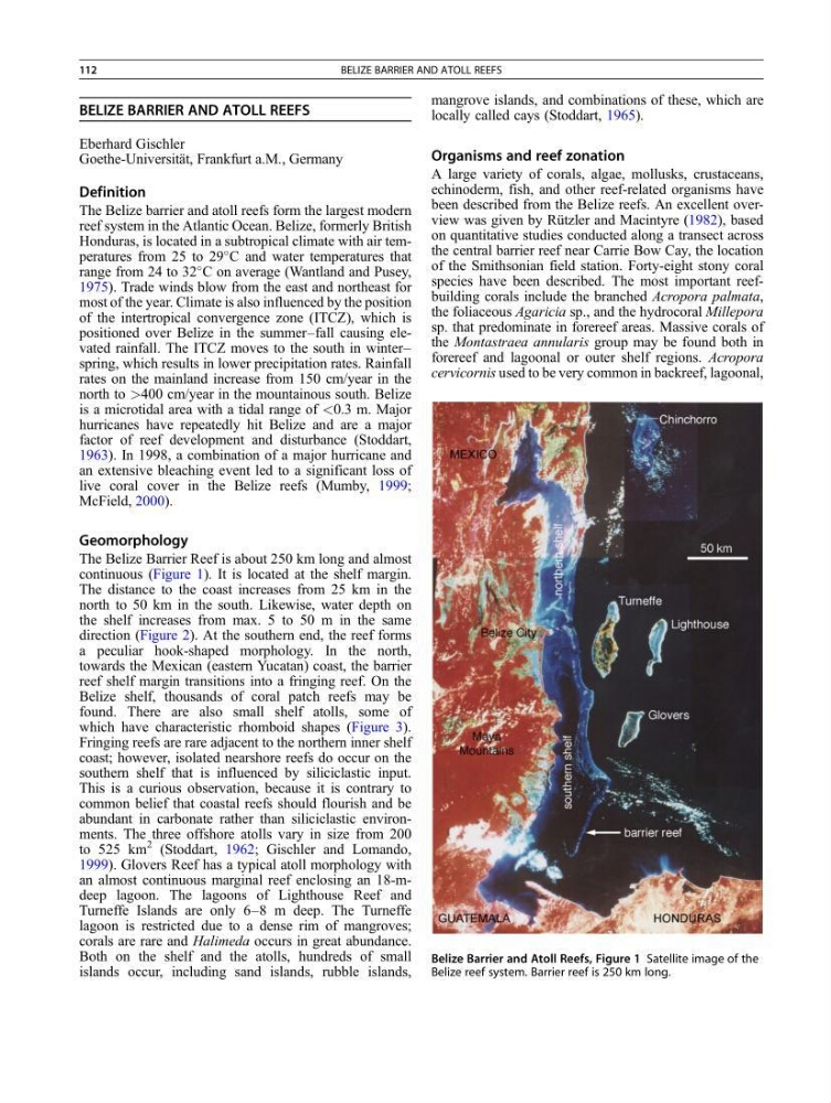
The Belize Barrier Reef is about 250 km long and almost
continuous (Figure 1). It is located at the shelf margin.
The distance to the coast increases from 25 km in the
north to 50 km in the south. Likewise, water depth on
the shelf increases from max. 5 to 50 m in the same
direction (Figure 2). At the southern end, the reef forms
a peculiar hook-shaped morphology. In the north,
towards the Mexican (eastern Yucatan) coast, the barrier
reef shelf margin transitions into a fringing reef. On the
Belize shelf, thousands of coral patch reefs may be
found. There are also small shelf atolls, some of
which have characteristic rhomboid shapes (Figure 3).
Fringing reefs are rare adjacent to the northern inner shelf
coast; however, isolated nearshore reefs do occur on the
southern shelf that is influenced by siliciclastic input.
This is a curious observation, because it is contrary to
common belief that coastal reefs should flourish and be
abundant in carbonate rather than siliciclastic environments. The three offshore atolls vary in size from 200
to 525 km
2 (Stoddart, 1962; Gischler and Lomando,
1999). Glovers Reef has a typical atoll morphology with
an almost continuous marginal reef enclosing an 18-mdeep lagoon. The lagoons of Lighthouse Reef and
Turneffe Islands are only 6–8 m deep. The Turneffe
lagoon is restricted due to a dense rim of mangroves;
corals are rare and Halimeda occurs in great abundance.
Both on the shelf and the atolls, hundreds of small
islands occur, including sand islands, rubble islands,
mangrove islands, and combinations of these, which are
locally called cays (Stoddart, 1965).
Organisms and reef zonation
A large variety of corals, algae, mollusks, crustaceans,
echinoderm, fish, and other reef-related organisms have
been described from the Belize reefs. An excellent overview was given by Rützler and Macintyre (1982), based
on quantitative studies conducted along a transect across
the central barrier reef near Carrie Bow Cay, the location
of the Smithsonian field station. Forty-eight stony coral
species have been described. The most important reefbuilding corals include the branched Acropora palmata,
the foliaceous Agaricia sp., and the hydrocoral Millepora
sp. that predominate in forereef areas. Massive corals of
the Montastraea annularis group may be found both in
forereef and lagoonal or outer shelf regions. Acropora
cervicornis used to be very common in backreef, lagoonal,
Belize Barrier and Atoll Reefs, Figure 1 Satellite image of the
Belize reef system. Barrier reef is 250 km long.
112
BELIZE BARRIER AND ATOLL REEFS
Eberhard Gischler
Goethe-Universität, Frankfurt a.M., Germany
Definition
The Belize barrier and atoll reefs form the largest modern
reef system in the Atlantic Ocean. Belize, formerly British
Honduras, is located in a subtropical climate with air temperatures from 25 to 29
C and water temperatures that
range from 24 to 32
C on average (Wantland and Pusey,
1975). Trade winds blow from the east and northeast for
most of the year. Climate is also influenced by the position
of the intertropical convergence zone (ITCZ), which is
positioned over Belize in the summer–fall causing elevated rainfall. The ITCZ moves to the south in winter–
spring, which results in lower precipitation rates. Rainfall
rates on the mainland increase from 150 cm/year in the
north to >400 cm/year in the mountainous south. Belize
is a microtidal area with a tidal range of <0.3 m. Major
hurricanes have repeatedly hit Belize and are a major
factor of reef development and disturbance (Stoddart,
1963). In 1998, a combination of a major hurricane and
an extensive bleaching event led to a significant loss of
live coral cover in the Belize reefs (Mumby, 1999;
McField, 2000).
Geomorphology
The Belize Barrier Reef is about 250 km long and almost
continuous (Figure 1). It is located at the shelf margin.
The distance to the coast increases from 25 km in the
north to 50 km in the south. Likewise, water depth on
the shelf increases from max. 5 to 50 m in the same
direction (Figure 2). At the southern end, the reef forms
a peculiar hook-shaped morphology. In the north,
towards the Mexican (eastern Yucatan) coast, the barrier
reef shelf margin transitions into a fringing reef. On the
Belize shelf, thousands of coral patch reefs may be
found. There are also small shelf atolls, some of
which have characteristic rhomboid shapes (Figure 3).
Fringing reefs are rare adjacent to the northern inner shelf
coast; however, isolated nearshore reefs do occur on the
southern shelf that is influenced by siliciclastic input.
This is a curious observation, because it is contrary to
common belief that coastal reefs should flourish and be
abundant in carbonate rather than siliciclastic environments. The three offshore atolls vary in size from 200
to 525 km
2 (Stoddart, 1962; Gischler and Lomando,
1999). Glovers Reef has a typical atoll morphology with
an almost continuous marginal reef enclosing an 18-mdeep lagoon. The lagoons of Lighthouse Reef and
Turneffe Islands are only 6–8 m deep. The Turneffe
lagoon is restricted due to a dense rim of mangroves;
corals are rare and Halimeda occurs in great abundance.
Both on the shelf and the atolls, hundreds of small
islands occur, including sand islands, rubble islands,
mangrove islands, and combinations of these, which are
locally called cays (Stoddart, 1965).
Organisms and reef zonation
A large variety of corals, algae, mollusks, crustaceans,
echinoderm, fish, and other reef-related organisms have
been described from the Belize reefs. An excellent overview was given by Rützler and Macintyre (1982), based
on quantitative studies conducted along a transect across
the central barrier reef near Carrie Bow Cay, the location
of the Smithsonian field station. Forty-eight stony coral
species have been described. The most important reefbuilding corals include the branched Acropora palmata,
the foliaceous Agaricia sp., and the hydrocoral Millepora
sp. that predominate in forereef areas. Massive corals of
the Montastraea annularis group may be found both in
forereef and lagoonal or outer shelf regions. Acropora
cervicornis used to be very common in backreef, lagoonal,
Belize Barrier and Atoll Reefs, Figure 1 Satellite image of the
Belize reef system. Barrier reef is 250 km long.
112
BELIZE BARRIER AND ATOLL REEFS