

BAHAMAS
Paul Enos
University of Kansas, KS, Lawrence, USA
Definition
“Bahamas” denotes the Bahamas Archipelago of 700
islands and approximately 2,400 cays and rocks that
stretches from 27
36
0 to 19
52
0 N latitude and from 79
05
0
to 68
42
0 W longitude, a distance of about 1,300 km
(Figure 1). That includes the Caicos and Turks Islands as
well as Mouchoir, Silver, and Navidad Banks that are geographically, geologically, and ecologically part of the Bahamas, although separate entities politically. The land area of
the Bahamas Commonwealth is 13,900 km
2
, home to some
306,000 people on 30 of the islands and host to 4.6 million
tourists annually (Government of the Bahamas). By far
the largest part of the Bahamas, some 155,000 km
2
, lies
beneath the sea (Newell, 1955). Of interest here are the
vast shallow (<20 m) banks, the Great Bahama Bank
(GBB), the Little Bahama Bank (LBB), and the smaller
banks extending far to the southeast, encompassing about
125,000 km
2 (Bergman et al., 2010). The shallow banks
from Caicos to Navidad Bank add another 10,200 km
2
.
These banks are the largest area of coral-reef development
in the Western Hemisphere. The reefs were an important
resource for the indigenous Lucayans and were noted early
by European explorers, beginning with C. Columbus.
Introduction
The Bahama Banks, surrounded by deep water on all
sides, provide excellent analogs for the numerous isolated
carbonate platforms in the geological record. Sedimentologic studies in the Bahamas have been extensive, for
example, by Black (1933), Smith (1940), Illing (1954),
Cloud (1962), Purdy (1963), Ball (1967), Shinn et al.
(1969), Hardie (1977), Harris (1979), Hine et al. (1981),
Droxler and Schlager (1985), and numerous others. Basically, the broad platform interiors are blanketed by pellet
and grapestone (aggregate grains, typically of pellets)
sand with increasing mud content in the lee of larger
islands on the windward margins (Traverse and Ginsburg,
1966; Enos, 1974). The windward sides of the islands are
the favored sites of reefs and skeletal sands. Where island
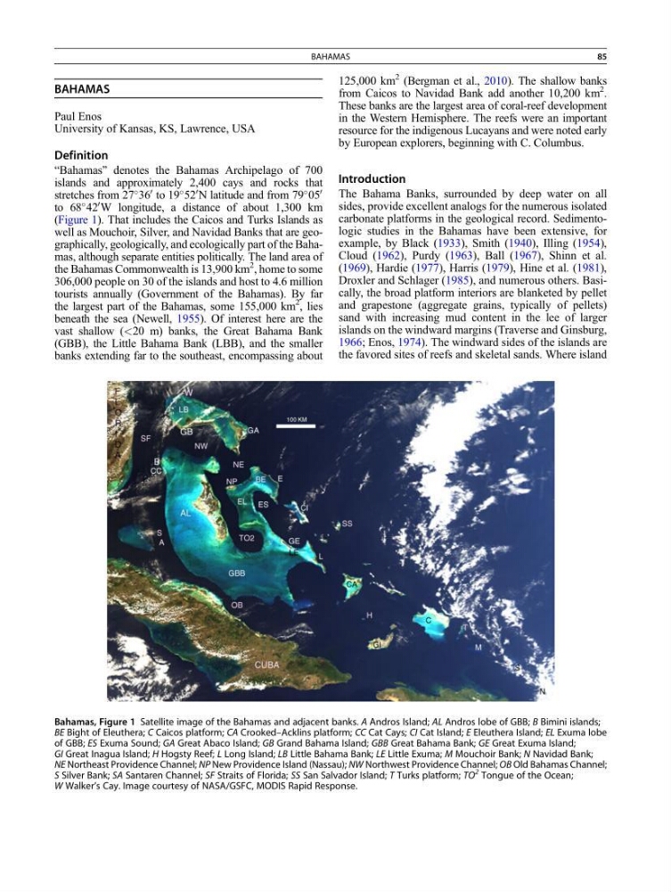
Bahamas, Figure 1 Satellite image of the Bahamas and adjacent banks. A Andros Island; AL Andros lobe of GBB; B Bimini islands;
BE Bight of Eleuthera; C Caicos platform; CA Crooked–Acklins platform; CC Cat Cays; CI Cat Island; E Eleuthera Island; EL Exuma lobe
of GBB; ES Exuma Sound; GA Great Abaco Island; GB Grand Bahama Island; GBB Great Bahama Bank; GE Great Exuma Island;
GI Great Inagua Island; H Hogsty Reef; L Long Island; LB Little Bahama Bank; LE Little Exuma; M Mouchoir Bank; N Navidad Bank;
NE Northeast Providence Channel; NP New Providence Island (Nassau); NW Northwest Providence Channel; OB Old Bahamas Channel;
S Silver Bank; SA Santaren Channel; SF Straits of Florida; SS San Salvador Island; T Turks platform; TO
2 Tongue of the Ocean;
W Walker’s Cay. Image courtesy of NASA/GSFC, MODIS Rapid Response.
BAHAMAS
85
Paul Enos
University of Kansas, KS, Lawrence, USA
Definition
“Bahamas” denotes the Bahamas Archipelago of 700
islands and approximately 2,400 cays and rocks that
stretches from 27
36
0 to 19
52
0 N latitude and from 79
05
0
to 68
42
0 W longitude, a distance of about 1,300 km
(Figure 1). That includes the Caicos and Turks Islands as
well as Mouchoir, Silver, and Navidad Banks that are geographically, geologically, and ecologically part of the Bahamas, although separate entities politically. The land area of
the Bahamas Commonwealth is 13,900 km
2
, home to some
306,000 people on 30 of the islands and host to 4.6 million
tourists annually (Government of the Bahamas). By far
the largest part of the Bahamas, some 155,000 km
2
, lies
beneath the sea (Newell, 1955). Of interest here are the
vast shallow (<20 m) banks, the Great Bahama Bank
(GBB), the Little Bahama Bank (LBB), and the smaller
banks extending far to the southeast, encompassing about
125,000 km
2 (Bergman et al., 2010). The shallow banks
from Caicos to Navidad Bank add another 10,200 km
2
.
These banks are the largest area of coral-reef development
in the Western Hemisphere. The reefs were an important
resource for the indigenous Lucayans and were noted early
by European explorers, beginning with C. Columbus.
Introduction
The Bahama Banks, surrounded by deep water on all
sides, provide excellent analogs for the numerous isolated
carbonate platforms in the geological record. Sedimentologic studies in the Bahamas have been extensive, for
example, by Black (1933), Smith (1940), Illing (1954),
Cloud (1962), Purdy (1963), Ball (1967), Shinn et al.
(1969), Hardie (1977), Harris (1979), Hine et al. (1981),
Droxler and Schlager (1985), and numerous others. Basically, the broad platform interiors are blanketed by pellet
and grapestone (aggregate grains, typically of pellets)
sand with increasing mud content in the lee of larger
islands on the windward margins (Traverse and Ginsburg,
1966; Enos, 1974). The windward sides of the islands are
the favored sites of reefs and skeletal sands. Where island
Bahamas, Figure 1 Satellite image of the Bahamas and adjacent banks. A Andros Island; AL Andros lobe of GBB; B Bimini islands;
BE Bight of Eleuthera; C Caicos platform; CA Crooked–Acklins platform; CC Cat Cays; CI Cat Island; E Eleuthera Island; EL Exuma lobe
of GBB; ES Exuma Sound; GA Great Abaco Island; GB Grand Bahama Island; GBB Great Bahama Bank; GE Great Exuma Island;
GI Great Inagua Island; H Hogsty Reef; L Long Island; LB Little Bahama Bank; LE Little Exuma; M Mouchoir Bank; N Navidad Bank;
NE Northeast Providence Channel; NP New Providence Island (Nassau); NW Northwest Providence Channel; OB Old Bahamas Channel;
S Silver Bank; SA Santaren Channel; SF Straits of Florida; SS San Salvador Island; T Turks platform; TO
2 Tongue of the Ocean;
W Walker’s Cay. Image courtesy of NASA/GSFC, MODIS Rapid Response.
BAHAMAS
85