

26
K. WYRTKI:
is at about 300 m depth along the northern boundary of the gyre. The anticyclonic flow
in the gyre penetrates even deeper, certainly to the level of the intermediate water near
1000 m depth and much deeper in the huge Agulhas eddy off South Africa.
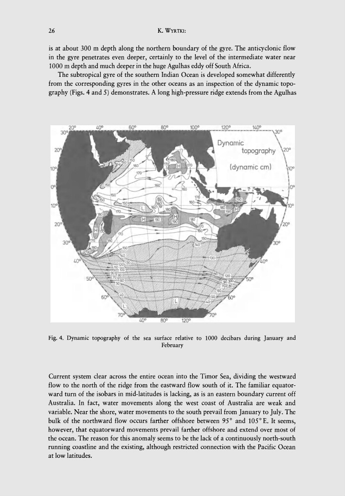
The subtropical gyre of the southern Indian Ocean is developed somewhat differently
from the corresponding gyres in the other oceans as an inspection of the dynamic topography (Figs. 4 and 5) demonstrates. A long high-pressure ridge extends from the Agulhas
(dynamic cm)
Fig. 4. Dynamic topography of the sea surface relative to 1000 decibars during January and
February
Current system clear across the entire ocean into the Timor Sea, dividing the westward
flow to the north of the ridge from the eastward flow south of it. The familiar equatorward turn of the isobars in mid-latitudes is lacking, as is an eastern boundary current off
Australia. In fact, water movements along the west coast of Australia are weak and
variable. Near the shore, water movements to the south prevail from January to July. The
bulk of the northward flow occurs farther offshore between 95° and 105° E. It seems,
however, that equatorward movements prevail farther offshore and extend over most of
the ocean. The reason for this anomaly seems to be the lack of a continuously north-south
running coastline and the existing, although restricted connection with the Pacific Ocean
at low latitudes.
K. WYRTKI:
is at about 300 m depth along the northern boundary of the gyre. The anticyclonic flow
in the gyre penetrates even deeper, certainly to the level of the intermediate water near
1000 m depth and much deeper in the huge Agulhas eddy off South Africa.
The subtropical gyre of the southern Indian Ocean is developed somewhat differently
from the corresponding gyres in the other oceans as an inspection of the dynamic topography (Figs. 4 and 5) demonstrates. A long high-pressure ridge extends from the Agulhas
(dynamic cm)
Fig. 4. Dynamic topography of the sea surface relative to 1000 decibars during January and
February
Current system clear across the entire ocean into the Timor Sea, dividing the westward
flow to the north of the ridge from the eastward flow south of it. The familiar equatorward turn of the isobars in mid-latitudes is lacking, as is an eastern boundary current off
Australia. In fact, water movements along the west coast of Australia are weak and
variable. Near the shore, water movements to the south prevail from January to July. The
bulk of the northward flow occurs farther offshore between 95° and 105° E. It seems,
however, that equatorward movements prevail farther offshore and extend over most of
the ocean. The reason for this anomaly seems to be the lack of a continuously north-south
running coastline and the existing, although restricted connection with the Pacific Ocean
at low latitudes.