

12
D. H. JOHNSON:
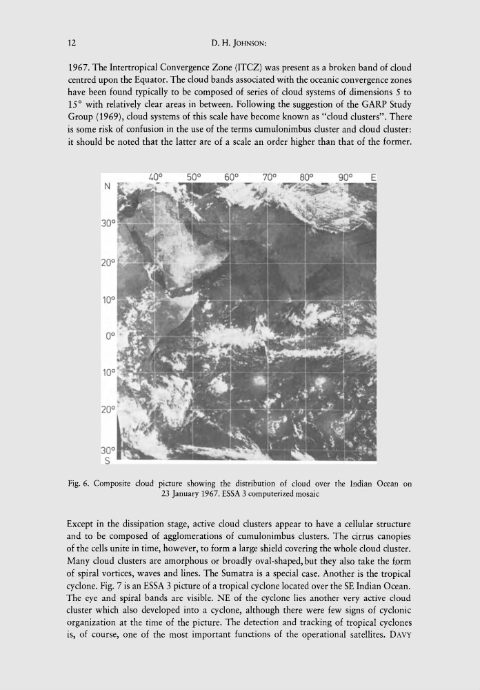
1967. The Intertropical Convergence Zone (lTCZ) was present as a broken band of cloud
centred upon the Equator. The cloud bands associated with the oceanic convergence zones
have been found typically to be composed of series of cloud systems of dimensions 5 to
15 0 with relatively clear areas in between. Following the suggestion of the CARP Study
Croup (1969), cloud systems of this scale have become known as "cloud clusters". There
is some risk of confusion in the use of the terms cumulonimbus cluster and cloud cluster:
it should be noted that the latter are of a scale an order higher than that of the former.
Fig. 6. Composite cloud picture showing the distribution of cloud over the Indian Ocean on
23 January 1967. ESSA 3 computerized mosaic
Except in the dissipation stage, active cloud clusters appear to have a cellular structure
and to be composed of agglomerations of cumulonimbus clusters. The cirrus canopies
of the cells unite in time, however, to form a large shield covering the whole cloud cluster.
Many cloud clusters are amorphous or broadly oval-shaped, but they also take the f.orm
of spiral vortices, waves and lines. The Sumatra is a special case. Another is the tropical
cyclone. Fig. 7 is an ESSA 3 picture of a tropical cyclone located over the SE Indian Ocean.
The eye and spiral bands are visible. NE of the cyclone lies another very active cloud
cluster which also developed into a cyclone, although there were few signs of cyclonic
organization at the time of the picture. The detection and tracking of tropical cyclones
is, of course, one of the most important functions of the operational satellites. DAVY
D. H. JOHNSON:
1967. The Intertropical Convergence Zone (lTCZ) was present as a broken band of cloud
centred upon the Equator. The cloud bands associated with the oceanic convergence zones
have been found typically to be composed of series of cloud systems of dimensions 5 to
15 0 with relatively clear areas in between. Following the suggestion of the CARP Study
Croup (1969), cloud systems of this scale have become known as "cloud clusters". There
is some risk of confusion in the use of the terms cumulonimbus cluster and cloud cluster:
it should be noted that the latter are of a scale an order higher than that of the former.
Fig. 6. Composite cloud picture showing the distribution of cloud over the Indian Ocean on
23 January 1967. ESSA 3 computerized mosaic
Except in the dissipation stage, active cloud clusters appear to have a cellular structure
and to be composed of agglomerations of cumulonimbus clusters. The cirrus canopies
of the cells unite in time, however, to form a large shield covering the whole cloud cluster.
Many cloud clusters are amorphous or broadly oval-shaped, but they also take the f.orm
of spiral vortices, waves and lines. The Sumatra is a special case. Another is the tropical
cyclone. Fig. 7 is an ESSA 3 picture of a tropical cyclone located over the SE Indian Ocean.
The eye and spiral bands are visible. NE of the cyclone lies another very active cloud
cluster which also developed into a cyclone, although there were few signs of cyclonic
organization at the time of the picture. The detection and tracking of tropical cyclones
is, of course, one of the most important functions of the operational satellites. DAVY