

1.6
Biogenic Sedimentation of the Persian Gulf
E. SEIBOlD
The remains of skeletal hard parts in marine sediments are of particular interest to
the geologist. If he is able to relate these remains in recent sediments to the environment
of deposition (water movement, water chemistry, water depth, distance from land,
distance from the open ocean, bottom type, etc.) he is then able to deduce the environment
of deposition of ancient sediments.
With this goal in mind a team of geologists from the Geological-Paleontological
Institute of Kiel University took part in the International Indian Ocean Expedition and
visited the NE part of the Persian Gulf from March 3 to April 24, 1965 (DIETRICH et aI.,
1966). Detailed descriptions of the results thus far completed are to be found in the
"Meteor-Forschungsergebnisse" (see references).
I. Environmental Framework
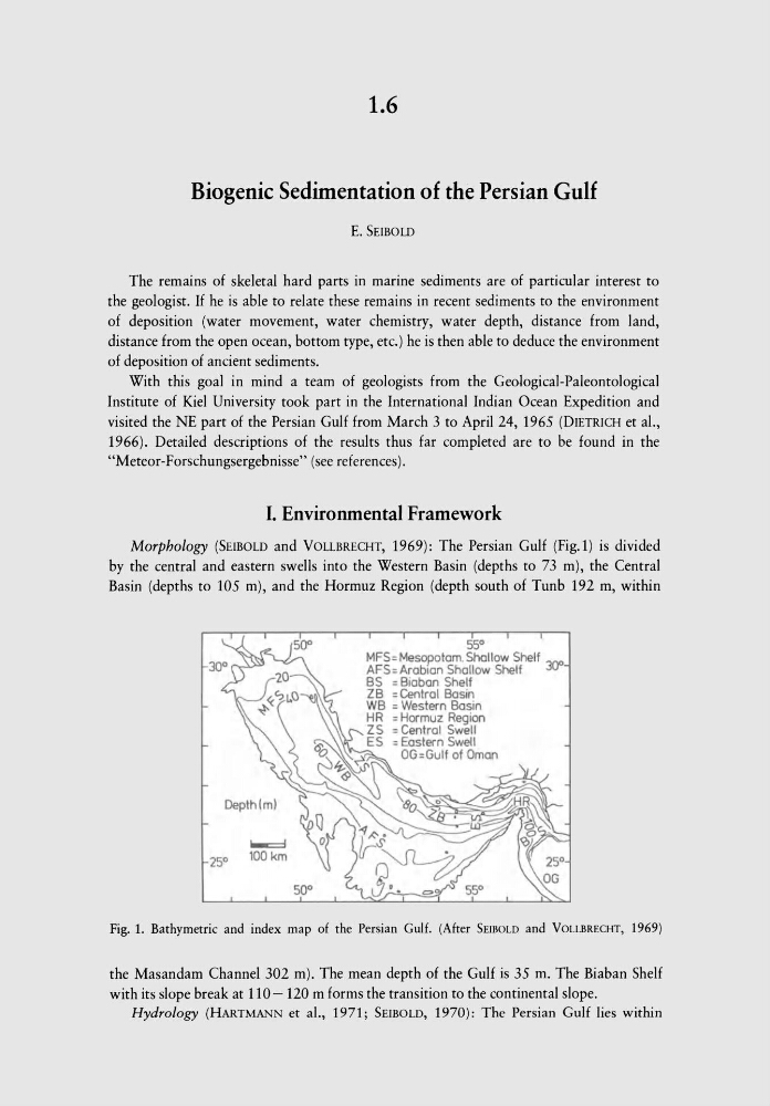
Morphology (SEIBOLD and VOLLBRECHT, 1969): The Persian Gulf (Fig.1) is divided
by the central and eastern swells into the Western Basin (depths to 73 m), the Central
Basin (depths to 105 m), and the Hormuz Region (depth south of Tunb 192 m, within
55°
MFS= Mesopotam. Shallow Shelf 3()0
AFS= Arabian Shallow Shelf
BS = Biaban Shelf
«SloO} ZB = Central Basin
~
WB = Western Basin
H R = Hormuz Region
ZS = Central Swell
6:
ES = Eastern Swell
V
~
OG=Gulf of Oman
~<9 J'
Depth!m)
~
100km
50°
Fig. 1. Bathymetric and index map of the Persian Gulf. (After SEIBOLD and VOLLBRECHT, 1969)
the Masandam Channel 302 m). The mean depth of the Gulf is 35 m. The Biaban Shelf
with its slope break at 110- 120 m forms the transition to the continental slope.
Hydrology (HARTMANN et ai., 1971; SEIBOLD, 1970): The Persian Gulf lies within
Biogenic Sedimentation of the Persian Gulf
E. SEIBOlD
The remains of skeletal hard parts in marine sediments are of particular interest to
the geologist. If he is able to relate these remains in recent sediments to the environment
of deposition (water movement, water chemistry, water depth, distance from land,
distance from the open ocean, bottom type, etc.) he is then able to deduce the environment
of deposition of ancient sediments.
With this goal in mind a team of geologists from the Geological-Paleontological
Institute of Kiel University took part in the International Indian Ocean Expedition and
visited the NE part of the Persian Gulf from March 3 to April 24, 1965 (DIETRICH et aI.,
1966). Detailed descriptions of the results thus far completed are to be found in the
"Meteor-Forschungsergebnisse" (see references).
I. Environmental Framework
Morphology (SEIBOLD and VOLLBRECHT, 1969): The Persian Gulf (Fig.1) is divided
by the central and eastern swells into the Western Basin (depths to 73 m), the Central
Basin (depths to 105 m), and the Hormuz Region (depth south of Tunb 192 m, within
55°
MFS= Mesopotam. Shallow Shelf 3()0
AFS= Arabian Shallow Shelf
BS = Biaban Shelf
«SloO} ZB = Central Basin
~
WB = Western Basin
H R = Hormuz Region
ZS = Central Swell
6:
ES = Eastern Swell
V
~
OG=Gulf of Oman
~<9 J'
Depth!m)
~
100km
50°
Fig. 1. Bathymetric and index map of the Persian Gulf. (After SEIBOLD and VOLLBRECHT, 1969)
the Masandam Channel 302 m). The mean depth of the Gulf is 35 m. The Biaban Shelf
with its slope break at 110- 120 m forms the transition to the continental slope.
Hydrology (HARTMANN et ai., 1971; SEIBOLD, 1970): The Persian Gulf lies within