

One example of a systemic definition is given by Oertel
(1985) who suggested that a barrier island should be
considered as the focal element of a much larger barrier
island system, consisting of six major elements: (1) mainland, (2) back-barrier lagoon, (3) inlet and inlet deltas,
(4) barrier island, (5) barrier platform, and (6) shoreface.
A lack of any one of these elements would result in misuse
of the term barrier island.
According to the criteria from Oertel (1985), a recent
survey by Stutz and Pilkey (2011) based on global satellite
data combined with topographic and navigational charts
identified 2,149 individual barrier islands totaling
20,783 km in length, taking up about 10 % of all continental shorelines. In this case only open-ocean barrier islands
are taken into account in the survey due to the limitations
of the criteria. However, if the criteria are not restricted to
the systemic definition but include other islands that meet
the descriptive definition as given in this article, another
category of barrier islands characterized by sheltered,
low-wave energy coastal environments (so-called fetchlimited) would be applicable. Pilkey et al. (2009) reported
the existence of more than 15,000 fetch-limited barrier
islands developed in the sheltered waters of fjords, bays,
lagoons, and behind coral reefs. Due to the absence of
driving forces under fair-weather conditions and low sediment availability, development of fetch-limited barrier
islands is strongly dependent upon stochastic extreme
events (e.g., storms, floods). Fetch-limited barrier islands
have a much smaller size than open-ocean barrier islands.
They are typically short (~1 km), narrow (some tens of
meters), and low lying (mostly less than 3 m above the
mean sea level), while open-ocean barrier islands have
an average length of 8.8 km and a width of 0.7 km,
according to Stutz and Pilkey (2011). Dune ridges higher
than 10 m can also develop on some open-ocean barrier
islands if aeolian onshore transport is strong and sediment
source is abundant (e.g., the Algarve barrier island chains
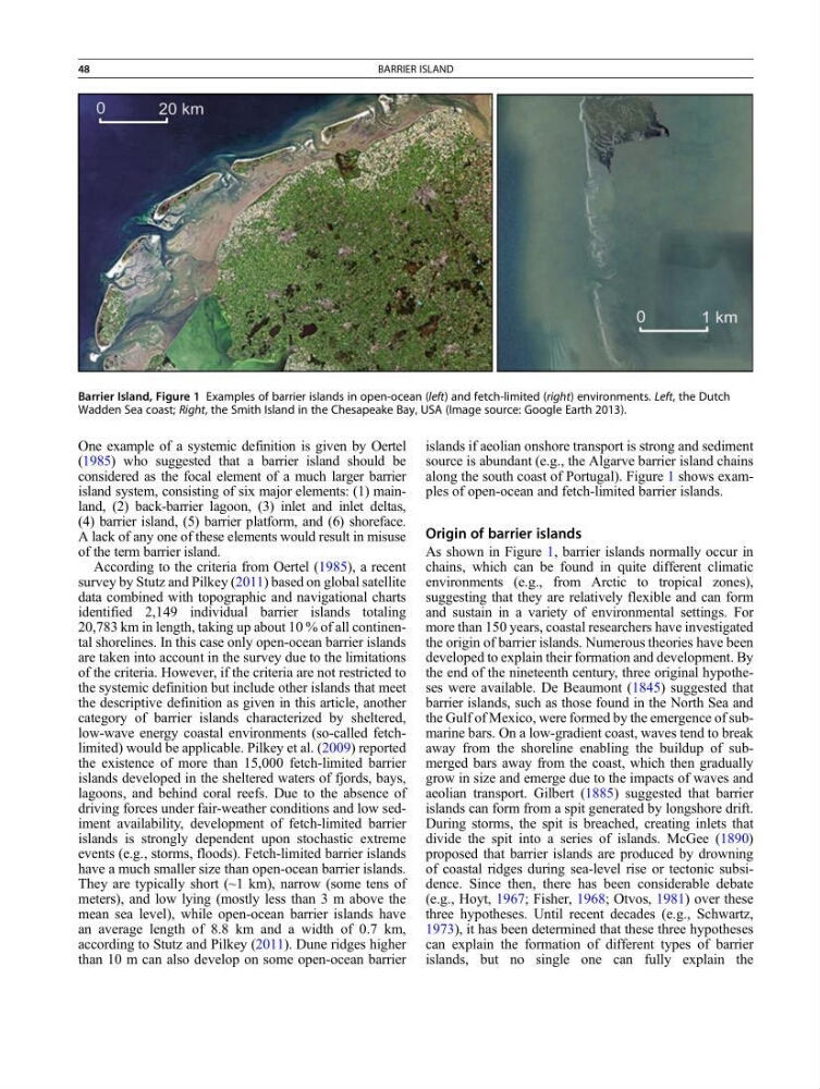
along the south coast of Portugal). Figure 1 shows examples of open-ocean and fetch-limited barrier islands.
Origin of barrier islands
As shown in Figure 1, barrier islands normally occur in
chains, which can be found in quite different climatic
environments (e.g., from Arctic to tropical zones),
suggesting that they are relatively flexible and can form
and sustain in a variety of environmental settings. For
more than 150 years, coastal researchers have investigated
the origin of barrier islands. Numerous theories have been
developed to explain their formation and development. By
the end of the nineteenth century, three original hypotheses were available. De Beaumont (1845) suggested that
barrier islands, such as those found in the North Sea and
the Gulf of Mexico, were formed by the emergence of submarine bars. On a low-gradient coast, waves tend to break
away from the shoreline enabling the buildup of submerged bars away from the coast, which then gradually
grow in size and emerge due to the impacts of waves and
aeolian transport. Gilbert (1885) suggested that barrier
islands can form from a spit generated by longshore drift.
During storms, the spit is breached, creating inlets that
divide the spit into a series of islands. McGee (1890)
proposed that barrier islands are produced by drowning
of coastal ridges during sea-level rise or tectonic subsidence. Since then, there has been considerable debate
(e.g., Hoyt, 1967; Fisher, 1968; Otvos, 1981) over these
three hypotheses. Until recent decades (e.g., Schwartz,
1973), it has been determined that these three hypotheses
can explain the formation of different types of barrier
islands, but no single one can fully explain the
Barrier Island, Figure 1 Examples of barrier islands in open-ocean (left) and fetch-limited (right) environments. Left, the Dutch
Wadden Sea coast; Right, the Smith Island in the Chesapeake Bay, USA (Image source: Google Earth 2013).
48
BARRIER ISLAND
(1985) who suggested that a barrier island should be
considered as the focal element of a much larger barrier
island system, consisting of six major elements: (1) mainland, (2) back-barrier lagoon, (3) inlet and inlet deltas,
(4) barrier island, (5) barrier platform, and (6) shoreface.
A lack of any one of these elements would result in misuse
of the term barrier island.
According to the criteria from Oertel (1985), a recent
survey by Stutz and Pilkey (2011) based on global satellite
data combined with topographic and navigational charts
identified 2,149 individual barrier islands totaling
20,783 km in length, taking up about 10 % of all continental shorelines. In this case only open-ocean barrier islands
are taken into account in the survey due to the limitations
of the criteria. However, if the criteria are not restricted to
the systemic definition but include other islands that meet
the descriptive definition as given in this article, another
category of barrier islands characterized by sheltered,
low-wave energy coastal environments (so-called fetchlimited) would be applicable. Pilkey et al. (2009) reported
the existence of more than 15,000 fetch-limited barrier
islands developed in the sheltered waters of fjords, bays,
lagoons, and behind coral reefs. Due to the absence of
driving forces under fair-weather conditions and low sediment availability, development of fetch-limited barrier
islands is strongly dependent upon stochastic extreme
events (e.g., storms, floods). Fetch-limited barrier islands
have a much smaller size than open-ocean barrier islands.
They are typically short (~1 km), narrow (some tens of
meters), and low lying (mostly less than 3 m above the
mean sea level), while open-ocean barrier islands have
an average length of 8.8 km and a width of 0.7 km,
according to Stutz and Pilkey (2011). Dune ridges higher
than 10 m can also develop on some open-ocean barrier
islands if aeolian onshore transport is strong and sediment
source is abundant (e.g., the Algarve barrier island chains
along the south coast of Portugal). Figure 1 shows examples of open-ocean and fetch-limited barrier islands.
Origin of barrier islands
As shown in Figure 1, barrier islands normally occur in
chains, which can be found in quite different climatic
environments (e.g., from Arctic to tropical zones),
suggesting that they are relatively flexible and can form
and sustain in a variety of environmental settings. For
more than 150 years, coastal researchers have investigated
the origin of barrier islands. Numerous theories have been
developed to explain their formation and development. By
the end of the nineteenth century, three original hypotheses were available. De Beaumont (1845) suggested that
barrier islands, such as those found in the North Sea and
the Gulf of Mexico, were formed by the emergence of submarine bars. On a low-gradient coast, waves tend to break
away from the shoreline enabling the buildup of submerged bars away from the coast, which then gradually
grow in size and emerge due to the impacts of waves and
aeolian transport. Gilbert (1885) suggested that barrier
islands can form from a spit generated by longshore drift.
During storms, the spit is breached, creating inlets that
divide the spit into a series of islands. McGee (1890)
proposed that barrier islands are produced by drowning
of coastal ridges during sea-level rise or tectonic subsidence. Since then, there has been considerable debate
(e.g., Hoyt, 1967; Fisher, 1968; Otvos, 1981) over these
three hypotheses. Until recent decades (e.g., Schwartz,
1973), it has been determined that these three hypotheses
can explain the formation of different types of barrier
islands, but no single one can fully explain the
Barrier Island, Figure 1 Examples of barrier islands in open-ocean (left) and fetch-limited (right) environments. Left, the Dutch
Wadden Sea coast; Right, the Smith Island in the Chesapeake Bay, USA (Image source: Google Earth 2013).
48
BARRIER ISLAND