

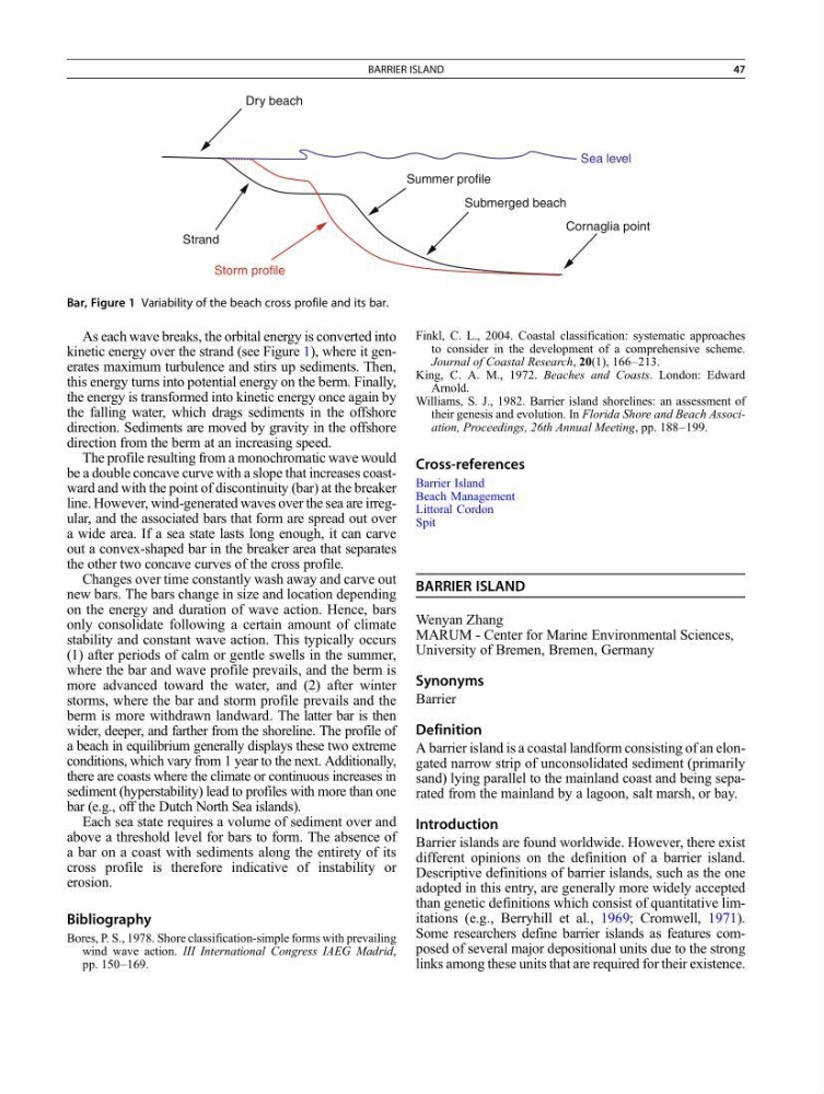
As each wave breaks, the orbital energy is converted into
kinetic energy over the strand (see Figure 1), where it generates maximum turbulence and stirs up sediments. Then,
this energy turns into potential energy on the berm. Finally,
the energy is transformed into kinetic energy once again by
the falling water, which drags sediments in the offshore
direction. Sediments are moved by gravity in the offshore
direction from the berm at an increasing speed.
The profile resulting from a monochromatic wave would
be a double concave curve with a slope that increases coastward and with the point of discontinuity (bar) at the breaker
line. However, wind-generated waves over the sea are irregular, and the associated bars that form are spread out over
a wide area. If a sea state lasts long enough, it can carve
out a convex-shaped bar in the breaker area that separates
the other two concave curves of the cross profile.
Changes over time constantly wash away and carve out
new bars. The bars change in size and location depending
on the energy and duration of wave action. Hence, bars
only consolidate following a certain amount of climate
stability and constant wave action. This typically occurs
(1) after periods of calm or gentle swells in the summer,
where the bar and wave profile prevails, and the berm is
more advanced toward the water, and (2) after winter
storms, where the bar and storm profile prevails and the
berm is more withdrawn landward. The latter bar is then
wider, deeper, and farther from the shoreline. The profile of
a beach in equilibrium generally displays these two extreme
conditions, which vary from 1 year to the next. Additionally,
there are coasts where the climate or continuous increases in
sediment (hyperstability) lead to profiles with more than one
bar (e.g., off the Dutch North Sea islands).
Each sea state requires a volume of sediment over and
above a threshold level for bars to form. The absence of
a bar on a coast with sediments along the entirety of its
cross profile is therefore indicative of instability or
erosion.
Bibliography
Bores, P. S., 1978. Shore classification-simple forms with prevailing
wind wave action. III International Congress IAEG Madrid,
pp. 150–169.
Finkl, C. L., 2004. Coastal classification: systematic approaches
to consider in the development of a comprehensive scheme.
Journal of Coastal Research, 20(1), 166–213.
King, C. A. M., 1972. Beaches and Coasts. London: Edward
Arnold.
Williams, S. J., 1982. Barrier island shorelines: an assessment of
their genesis and evolution. In Florida Shore and Beach Association, Proceedings, 26th Annual Meeting, pp. 188–199.
Cross-references
Barrier Island
Beach Management
Littoral Cordon
Spit
BARRIER ISLAND
Wenyan Zhang
MARUM - Center for Marine Environmental Sciences,
University of Bremen, Bremen, Germany
Synonyms
Barrier
Definition
A barrier island is a coastal landform consisting of an elongated narrow strip of unconsolidated sediment (primarily
sand) lying parallel to the mainland coast and being separated from the mainland by a lagoon, salt marsh, or bay.
Introduction
Barrier islands are found worldwide. However, there exist
different opinions on the definition of a barrier island.
Descriptive definitions of barrier islands, such as the one
adopted in this entry, are generally more widely accepted
than genetic definitions which consist of quantitative limitations (e.g., Berryhill et al., 1969; Cromwell, 1971).
Some researchers define barrier islands as features composed of several major depositional units due to the strong
links among these units that are required for their existence.
Dry beach
Strand
Summer profile
Submerged beach
Cornaglia point
Storm profile
Sea level
Bar, Figure 1 Variability of the beach cross profile and its bar.
BARRIER ISLAND
47
kinetic energy over the strand (see Figure 1), where it generates maximum turbulence and stirs up sediments. Then,
this energy turns into potential energy on the berm. Finally,
the energy is transformed into kinetic energy once again by
the falling water, which drags sediments in the offshore
direction. Sediments are moved by gravity in the offshore
direction from the berm at an increasing speed.
The profile resulting from a monochromatic wave would
be a double concave curve with a slope that increases coastward and with the point of discontinuity (bar) at the breaker
line. However, wind-generated waves over the sea are irregular, and the associated bars that form are spread out over
a wide area. If a sea state lasts long enough, it can carve
out a convex-shaped bar in the breaker area that separates
the other two concave curves of the cross profile.
Changes over time constantly wash away and carve out
new bars. The bars change in size and location depending
on the energy and duration of wave action. Hence, bars
only consolidate following a certain amount of climate
stability and constant wave action. This typically occurs
(1) after periods of calm or gentle swells in the summer,
where the bar and wave profile prevails, and the berm is
more advanced toward the water, and (2) after winter
storms, where the bar and storm profile prevails and the
berm is more withdrawn landward. The latter bar is then
wider, deeper, and farther from the shoreline. The profile of
a beach in equilibrium generally displays these two extreme
conditions, which vary from 1 year to the next. Additionally,
there are coasts where the climate or continuous increases in
sediment (hyperstability) lead to profiles with more than one
bar (e.g., off the Dutch North Sea islands).
Each sea state requires a volume of sediment over and
above a threshold level for bars to form. The absence of
a bar on a coast with sediments along the entirety of its
cross profile is therefore indicative of instability or
erosion.
Bibliography
Bores, P. S., 1978. Shore classification-simple forms with prevailing
wind wave action. III International Congress IAEG Madrid,
pp. 150–169.
Finkl, C. L., 2004. Coastal classification: systematic approaches
to consider in the development of a comprehensive scheme.
Journal of Coastal Research, 20(1), 166–213.
King, C. A. M., 1972. Beaches and Coasts. London: Edward
Arnold.
Williams, S. J., 1982. Barrier island shorelines: an assessment of
their genesis and evolution. In Florida Shore and Beach Association, Proceedings, 26th Annual Meeting, pp. 188–199.
Cross-references
Barrier Island
Beach Management
Littoral Cordon
Spit
BARRIER ISLAND
Wenyan Zhang
MARUM - Center for Marine Environmental Sciences,
University of Bremen, Bremen, Germany
Synonyms
Barrier
Definition
A barrier island is a coastal landform consisting of an elongated narrow strip of unconsolidated sediment (primarily
sand) lying parallel to the mainland coast and being separated from the mainland by a lagoon, salt marsh, or bay.
Introduction
Barrier islands are found worldwide. However, there exist
different opinions on the definition of a barrier island.
Descriptive definitions of barrier islands, such as the one
adopted in this entry, are generally more widely accepted
than genetic definitions which consist of quantitative limitations (e.g., Berryhill et al., 1969; Cromwell, 1971).
Some researchers define barrier islands as features composed of several major depositional units due to the strong
links among these units that are required for their existence.
Dry beach
Strand
Summer profile
Submerged beach
Cornaglia point
Storm profile
Sea level
Bar, Figure 1 Variability of the beach cross profile and its bar.
BARRIER ISLAND
47