

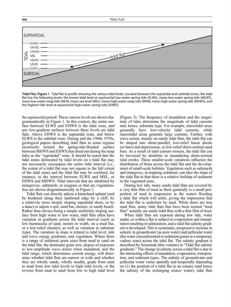
the equinoctial period. These various levels are shown diagrammatically in Figure 1. In this context, the entire surface between ELWS and EHWS is the tidal zone, and
any low-gradient surfaces between these levels are tidal
flats. Above EHWS is the supratidal zone, and below
ELWS is the subtidal zone. During and the 1960s 1970s,
geological papers describing tidal flats in some regions
incorrectly termed the spring-tide-flooded surface
between MHWS and EHWS that dried out during the neap
tides as the “supratidal” zone. It should be noted that the
tidal zones delineated by tidal levels on a tidal flat may
not necessarily encompass the entire tidal interval (i.e.,
the extent of a tidal flat may not equate to the full extent
of the tidal zone) and the tidal flat may be confined, for
instance, to the interval between ELWS and MSL, or
EHWS and MHWN. Tidal intervals that are inhabited by
mangroves, saltmarsh, or seagrass or that are vegetationfree are shown diagrammatically in Figure 2.
Tidal flats can directly adjoin a hinterland upland (and
be bordered along their landward edge by a cliff, by
a relatively more steeply sloping supratidal shore, or by
a dune) or adjoin a spit, sand bar, chenier, or sandy beach.
Rather than always being a simple uniformly sloping surface from high water to low water, tidal flats often have
variation in gradients across the tidal interval (such as
low hummocks of sand, meters in width, on a mud flat,
or a low-relief chenier), as well as variation in substrate
types. The variation in slope is related to tidal level, tide
and wave energy gradients, and vegetation. Where there
is a range of sediment grain sizes from mud to sand on
the tidal flat, the dominant grain size, degree of exposure
to low-amplitude wave action when inundated, and the
tidal range, which determines current energy, will determine whether tidal flats are narrow or wide and whether
they are wholly sandy, wholly muddy, grade from sand
to mud from low tidal levels to high tidal levels, or the
reverse from mud to sand from low to high tidal level
(Figure 3). The frequency of inundation and the magnitude of tides determine the magnitude of tidal currents
and, hence, substrate type. For example, microtidal areas
generally have low-velocity tidal currents, while
macrotidal areas generate large currents. Further, with
wave action, mainly on sandy tidal flats, the tidal flat can
be shaped into shore-parallel, low-relief linear shoals
(or bars) and depressions, or low-relief shore-normal sand
bars. As a result of tidal current erosion, the tidal flat can
be traversed by dendritic to meandering shore-normal
tidal creeks. These smaller-scale variations influence the
distribution of biota across the tidal flat and the development of small-scale habitats. Vegetation such as saltmarsh
and mangrove, in trapping sediment, can alter the slope of
the tidal flat in that there is a relative buildup of sediment
in the vegetated zone.
During low tide, many sandy tidal flats are covered by
a very thin film of mud as there generally is a small proportion of mud in suspension in the waters flooding
a tidal flat which will settle, giving the impression that
the tidal flat is underlain by mud. While there are true
mud flats, many tidal flats that have been termed “mud
flats” actually are sandy tidal flats with a thin film of mud.
When tidal flats are exposed during low tide, water
under, or within a flat is subject to evaporation and transpiration resulting in salinization, and a tidal flat salinity gradient is developed. This is systematic, progressive increase in
salinity in groundwater (as pore water) and pellicular water
(the water circumferential to sediment grains in a temporary
vadose zone) across the tidal flat. The salinity gradient is
described by Semeniuk (this volume) in “Tidal flat salinity
gradients.” The change in salinity across a tidal flat is due to
the interacting effects of inundation, evaporation, transpiration, and sediment types. The salinity of groundwater and
pellicular water varies spatially and temporally depending
on (1) the position of a tidal flat in an estuary (and hence
the salinity of the recharging source water); tidal flats
Tidal Flat, Figure 1 Tidal flat in profile showing the various tidal levels. Located between the supratidal and subtidal zones, the tidal
flat has the following levels: the lowest tidal level at equinoctial low-water spring tide (ELWS), mean low-water spring tide (MLWS),
mean low-water neap tide (MLN), mean sea level (MSL), mean high-water neap tide (MHN), mean high-water spring tide (MHWS), and
the highest tide level at equinoctial high-water spring tide (EHWS).
666
TIDAL FLAT