

(Western Australia), Fitzroy River estuary (Queensland),
Gulf of Saint Lawrence (Canada), Chesapeake Bay
(North America), and the Amazon estuary (Brazil).
In regard to the cultural or historical significance
(Category 2), estuaries may function as highly significant
systems to the local traditional owners or may carry historical significance. The Camargue in the estuary of the
Rhone (France) is an example of the former, and Port
Hacking (Australia) and the Thames (the United Kingdom) are examples of the latter.
Estuaries can also function as geohistorical sites
(Category 3) showing ancient sequences where earth history can be determined. In this regard, they hold records
over the past 7,000 years when sea level stabilized to its
present position of coastal history and valley-fill history
in their stratigraphy and stranded estuarine geomorphology (Roy, 1984). The estuarine sequences recording estuarine evolution documented in Australia and North
America (Fisher, 1969; Roy, 1984) are examples of the
geohistorical importance of estuaries and illustrate the
variety of pathways that an estuary may take in its development. Estuaries also hold records over the Pleistocene
of previous estuarine history in their stratigraphy and older
estuarine geomorphology.
Estuaries are excellent examples to illustrate modern
landscapes and settings (Category 4) where earth processes are still active. It is an environment where fluvial
sedimentation interacts with the estuarine basin; intraestuarine processes mobilize and deposit sediments into
shoals, platforms, and basin-fill sheets; flood and ebb tides
develop flood and ebb tidal deltas; and a plethora of biological, geochemical, hydrochemical, and physical processes at the finest scale result in a plethora of
sedimentary bedforms, sedimentary structures, sedimentary deposits, biogenic deposits, and mineral precipitates.
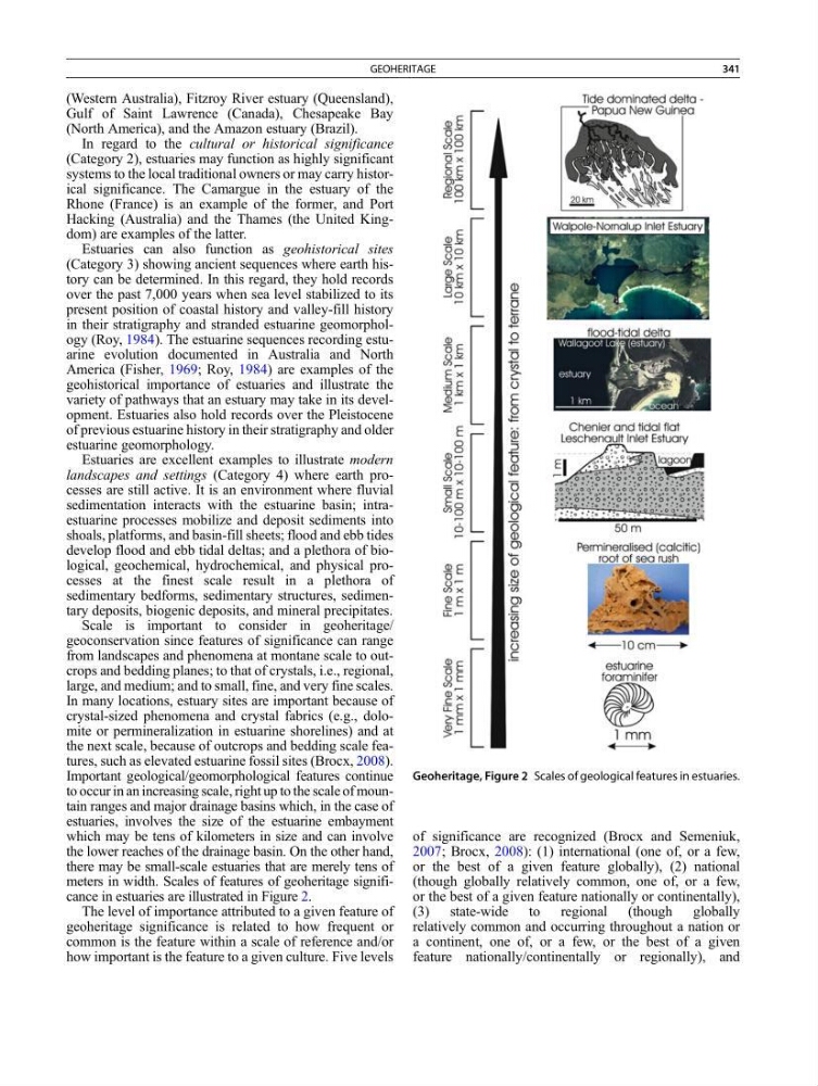
Scale is important to consider in geoheritage/
geoconservation since features of significance can range
from landscapes and phenomena at montane scale to outcrops and bedding planes; to that of crystals, i.e., regional,
large, and medium; and to small, fine, and very fine scales.
In many locations, estuary sites are important because of
crystal-sized phenomena and crystal fabrics (e.g., dolomite or permineralization in estuarine shorelines) and at
the next scale, because of outcrops and bedding scale features, such as elevated estuarine fossil sites (Brocx, 2008).
Important geological/geomorphological features continue
to occur in an increasing scale, right up to the scale of mountain ranges and major drainage basins which, in the case of
estuaries, involves the size of the estuarine embayment
which may be tens of kilometers in size and can involve
the lower reaches of the drainage basin. On the other hand,
there may be small-scale estuaries that are merely tens of
meters in width. Scales of features of geoheritage significance in estuaries are illustrated in Figure 2.
The level of importance attributed to a given feature of
geoheritage significance is related to how frequent or
common is the feature within a scale of reference and/or
how important is the feature to a given culture. Five levels
of significance are recognized (Brocx and Semeniuk,
2007; Brocx, 2008): (1) international (one of, or a few,
or the best of a given feature globally), (2) national
(though globally relatively common, one of, or a few,
or the best of a given feature nationally or continentally),
(3) state-wide to regional (though globally
relatively common and occurring throughout a nation or
a continent, one of, or a few, or the best of a given
feature nationally/continentally or regionally), and
Geoheritage, Figure 2 Scales of geological features in estuaries.
GEOHERITAGE
341
Gulf of Saint Lawrence (Canada), Chesapeake Bay
(North America), and the Amazon estuary (Brazil).
In regard to the cultural or historical significance
(Category 2), estuaries may function as highly significant
systems to the local traditional owners or may carry historical significance. The Camargue in the estuary of the
Rhone (France) is an example of the former, and Port
Hacking (Australia) and the Thames (the United Kingdom) are examples of the latter.
Estuaries can also function as geohistorical sites
(Category 3) showing ancient sequences where earth history can be determined. In this regard, they hold records
over the past 7,000 years when sea level stabilized to its
present position of coastal history and valley-fill history
in their stratigraphy and stranded estuarine geomorphology (Roy, 1984). The estuarine sequences recording estuarine evolution documented in Australia and North
America (Fisher, 1969; Roy, 1984) are examples of the
geohistorical importance of estuaries and illustrate the
variety of pathways that an estuary may take in its development. Estuaries also hold records over the Pleistocene
of previous estuarine history in their stratigraphy and older
estuarine geomorphology.
Estuaries are excellent examples to illustrate modern
landscapes and settings (Category 4) where earth processes are still active. It is an environment where fluvial
sedimentation interacts with the estuarine basin; intraestuarine processes mobilize and deposit sediments into
shoals, platforms, and basin-fill sheets; flood and ebb tides
develop flood and ebb tidal deltas; and a plethora of biological, geochemical, hydrochemical, and physical processes at the finest scale result in a plethora of
sedimentary bedforms, sedimentary structures, sedimentary deposits, biogenic deposits, and mineral precipitates.
Scale is important to consider in geoheritage/
geoconservation since features of significance can range
from landscapes and phenomena at montane scale to outcrops and bedding planes; to that of crystals, i.e., regional,
large, and medium; and to small, fine, and very fine scales.
In many locations, estuary sites are important because of
crystal-sized phenomena and crystal fabrics (e.g., dolomite or permineralization in estuarine shorelines) and at
the next scale, because of outcrops and bedding scale features, such as elevated estuarine fossil sites (Brocx, 2008).
Important geological/geomorphological features continue
to occur in an increasing scale, right up to the scale of mountain ranges and major drainage basins which, in the case of
estuaries, involves the size of the estuarine embayment
which may be tens of kilometers in size and can involve
the lower reaches of the drainage basin. On the other hand,
there may be small-scale estuaries that are merely tens of
meters in width. Scales of features of geoheritage significance in estuaries are illustrated in Figure 2.
The level of importance attributed to a given feature of
geoheritage significance is related to how frequent or
common is the feature within a scale of reference and/or
how important is the feature to a given culture. Five levels
of significance are recognized (Brocx and Semeniuk,
2007; Brocx, 2008): (1) international (one of, or a few,
or the best of a given feature globally), (2) national
(though globally relatively common, one of, or a few,
or the best of a given feature nationally or continentally),
(3) state-wide to regional (though globally
relatively common and occurring throughout a nation or
a continent, one of, or a few, or the best of a given
feature nationally/continentally or regionally), and
Geoheritage, Figure 2 Scales of geological features in estuaries.
GEOHERITAGE
341