

end-member types of estuaries as global “type examples”
of the variety forms expressed around the world in
response to climate, hydrodynamic setting, sediment
types, and framework geology. At this scale, geoheritage
recognizes the range of estuarine systems that are
manifested around the globe and attempts to address the
significance of the variety of these estuaries that have
formed in different geological, hydrological, sedimentological, and climatic settings within a variable biogeographic context. At the next level, geoheritage and
geoconservation can involve the geoconservation of geological processes and products operating and occurring
within estuaries, e.g., deltaic sedimentation and its variety
of landforms, sand platforms and their surface bedforms,
evolution of estuarine stratigraphy, stratigraphic/hydrologic interactions, and styles of hydrochemical mixing.
At the finest scale, geoheritage and geoconservation can
involve the recognition and geoconservation of microscale processes and products, often specific to an environmental setting and climate, e.g., diagenetic features such
as calcitization of shoreline rush rhizomes, occurrence of
dolomite, formation of pyrite nodules, the permineralization of skeletons, and the effects of freshwater seepage.
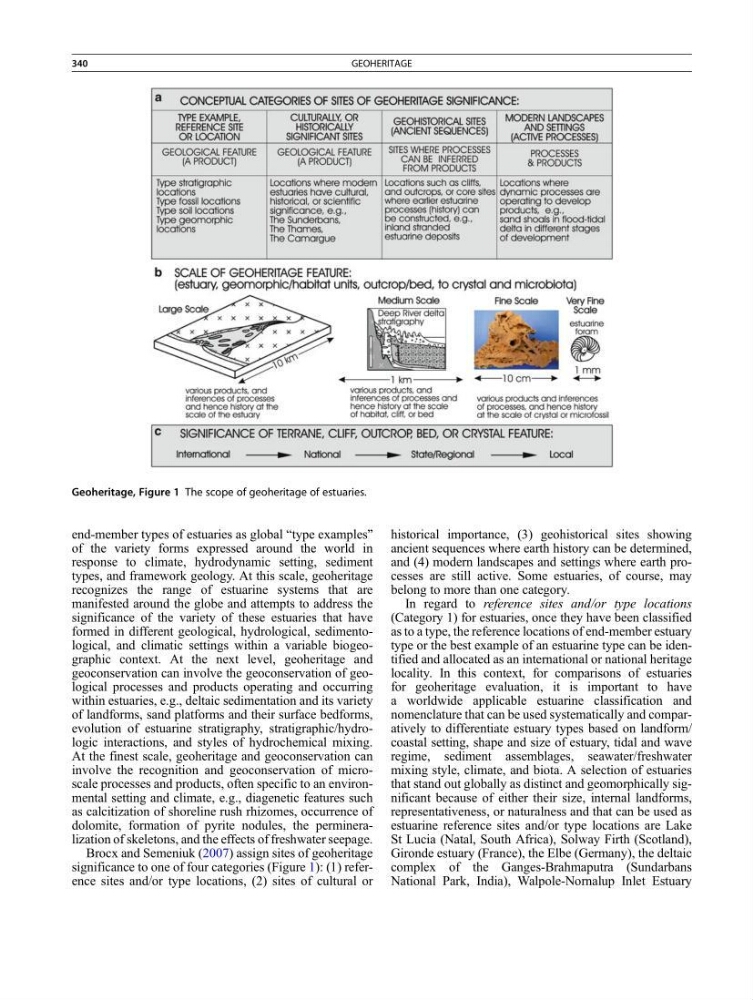
Brocx and Semeniuk (2007) assign sites of geoheritage
significance to one of four categories (Figure 1): (1) reference sites and/or type locations, (2) sites of cultural or
historical importance, (3) geohistorical sites showing
ancient sequences where earth history can be determined,
and (4) modern landscapes and settings where earth processes are still active. Some estuaries, of course, may
belong to more than one category.
In regard to reference sites and/or type locations
(Category 1) for estuaries, once they have been classified
as to a type, the reference locations of end-member estuary
type or the best example of an estuarine type can be identified and allocated as an international or national heritage
locality. In this context, for comparisons of estuaries
for geoheritage evaluation, it is important to have
a worldwide applicable estuarine classification and
nomenclature that can be used systematically and comparatively to differentiate estuary types based on landform/
coastal setting, shape and size of estuary, tidal and wave
regime, sediment assemblages, seawater/freshwater
mixing style, climate, and biota. A selection of estuaries
that stand out globally as distinct and geomorphically significant because of either their size, internal landforms,
representativeness, or naturalness and that can be used as
estuarine reference sites and/or type locations are Lake
St Lucia (Natal, South Africa), Solway Firth (Scotland),
Gironde estuary (France), the Elbe (Germany), the deltaic
complex of the Ganges-Brahmaputra (Sundarbans
National Park, India), Walpole-Nornalup Inlet Estuary
Geoheritage, Figure 1 The scope of geoheritage of estuaries.
340
GEOHERITAGE
of the variety forms expressed around the world in
response to climate, hydrodynamic setting, sediment
types, and framework geology. At this scale, geoheritage
recognizes the range of estuarine systems that are
manifested around the globe and attempts to address the
significance of the variety of these estuaries that have
formed in different geological, hydrological, sedimentological, and climatic settings within a variable biogeographic context. At the next level, geoheritage and
geoconservation can involve the geoconservation of geological processes and products operating and occurring
within estuaries, e.g., deltaic sedimentation and its variety
of landforms, sand platforms and their surface bedforms,
evolution of estuarine stratigraphy, stratigraphic/hydrologic interactions, and styles of hydrochemical mixing.
At the finest scale, geoheritage and geoconservation can
involve the recognition and geoconservation of microscale processes and products, often specific to an environmental setting and climate, e.g., diagenetic features such
as calcitization of shoreline rush rhizomes, occurrence of
dolomite, formation of pyrite nodules, the permineralization of skeletons, and the effects of freshwater seepage.
Brocx and Semeniuk (2007) assign sites of geoheritage
significance to one of four categories (Figure 1): (1) reference sites and/or type locations, (2) sites of cultural or
historical importance, (3) geohistorical sites showing
ancient sequences where earth history can be determined,
and (4) modern landscapes and settings where earth processes are still active. Some estuaries, of course, may
belong to more than one category.
In regard to reference sites and/or type locations
(Category 1) for estuaries, once they have been classified
as to a type, the reference locations of end-member estuary
type or the best example of an estuarine type can be identified and allocated as an international or national heritage
locality. In this context, for comparisons of estuaries
for geoheritage evaluation, it is important to have
a worldwide applicable estuarine classification and
nomenclature that can be used systematically and comparatively to differentiate estuary types based on landform/
coastal setting, shape and size of estuary, tidal and wave
regime, sediment assemblages, seawater/freshwater
mixing style, climate, and biota. A selection of estuaries
that stand out globally as distinct and geomorphically significant because of either their size, internal landforms,
representativeness, or naturalness and that can be used as
estuarine reference sites and/or type locations are Lake
St Lucia (Natal, South Africa), Solway Firth (Scotland),
Gironde estuary (France), the Elbe (Germany), the deltaic
complex of the Ganges-Brahmaputra (Sundarbans
National Park, India), Walpole-Nornalup Inlet Estuary
Geoheritage, Figure 1 The scope of geoheritage of estuaries.
340
GEOHERITAGE