

a function of the aircraft flying height and the beam
divergence. Small-footprint ALTM systems can enable
topographic mapping with average spatial resolutions
greater than 1 point per meter squared and achievable
positional accuracies in the range of 15–30 cm horizontal
(x, y) and 5–10 cm vertical (z) (Slatton et al ., 2007).
Data applications
ALTM surveys generate irregularly spaced x,y,z point
cloud data representing the ground and land cover. The
desired end product for many scientific and engineering
applications is to derive a bare-earth digital elevation
model (DEM) from the data. For multiple return ALTM
systems, typically only the last return points are utilized
because they have a higher probability of reflecting from
the true ground surface. Prior to DEM generation, the
point data typically undergo a process called filtering to
try and remove non-ground points due to such things as
buildings, vegetation, and other occluding objects
(Slatton et al., 2007). Many different filtering algorithms
have been proposed for ALTM data (e.g., Sithole and
Vosselman, 2004). Once the ground points are obtained
through filtering, an interpolation method is applied to
generate a regularly spaced grid of bare-earth elevations
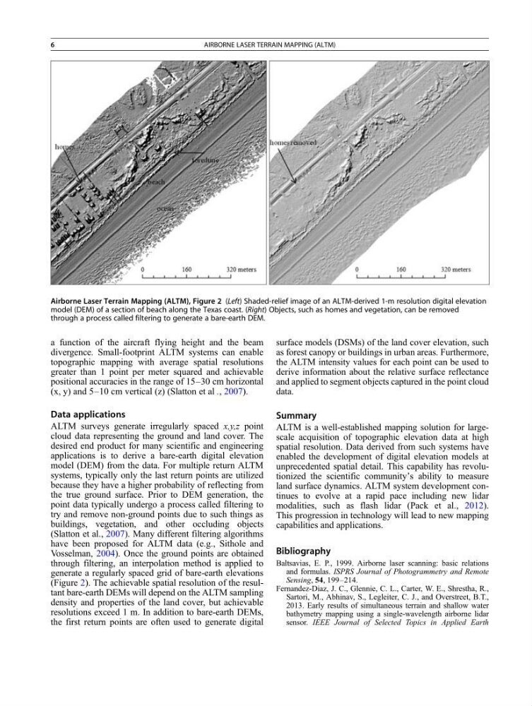
(Figure 2). The achievable spatial resolution of the resultant bare-earth DEMs will depend on the ALTM sampling
density and properties of the land cover, but achievable
resolutions exceed 1 m. In addition to bare-earth DEMs,
the first return points are often used to generate digital
surface models (DSMs) of the land cover elevation, such
as forest canopy or buildings in urban areas. Furthermore,
the ALTM intensity values for each point can be used to
derive information about the relative surface reflectance
and applied to segment objects captured in the point cloud
data.
Summary
ALTM is a well-established mapping solution for largescale acquisition of topographic elevation data at high
spatial resolution. Data derived from such systems have
enabled the development of digital elevation models at
unprecedented spatial detail. This capability has revolutionized the scientific community’s ability to measure
land surface dynamics. ALTM system development continues to evolve at a rapid pace including new lidar
modalities, such as flash lidar (Pack et al., 2012).
This progression in technology will lead to new mapping
capabilities and applications.
Bibliography
Baltsavias, E. P., 1999. Airborne laser scanning: basic relations
and formulas. ISPRS Journal of Photogrammetry and Remote
Sensing, 54, 199–214.
Fernandez-Diaz, J. C., Glennie, C. L., Carter, W. E., Shrestha, R.,
Sartori, M., Abhinav, S., Legleiter, C. J., and Overstreet, B.T.,
2013. Early results of simultaneous terrain and shallow water
bathymetry mapping using a single-wavelength airborne lidar
sensor. IEEE Journal of Selected Topics in Applied Earth
Airborne Laser Terrain Mapping (ALTM), Figure 2 (Left) Shaded-relief image of an ALTM-derived 1-m resolution digital elevation
model (DEM) of a section of beach along the Texas coast. (Right) Objects, such as homes and vegetation, can be removed
through a process called filtering to generate a bare-earth DEM.
6
AIRBORNE LASER TERRAIN MAPPING (ALTM)
divergence. Small-footprint ALTM systems can enable
topographic mapping with average spatial resolutions
greater than 1 point per meter squared and achievable
positional accuracies in the range of 15–30 cm horizontal
(x, y) and 5–10 cm vertical (z) (Slatton et al ., 2007).
Data applications
ALTM surveys generate irregularly spaced x,y,z point
cloud data representing the ground and land cover. The
desired end product for many scientific and engineering
applications is to derive a bare-earth digital elevation
model (DEM) from the data. For multiple return ALTM
systems, typically only the last return points are utilized
because they have a higher probability of reflecting from
the true ground surface. Prior to DEM generation, the
point data typically undergo a process called filtering to
try and remove non-ground points due to such things as
buildings, vegetation, and other occluding objects
(Slatton et al., 2007). Many different filtering algorithms
have been proposed for ALTM data (e.g., Sithole and
Vosselman, 2004). Once the ground points are obtained
through filtering, an interpolation method is applied to
generate a regularly spaced grid of bare-earth elevations
(Figure 2). The achievable spatial resolution of the resultant bare-earth DEMs will depend on the ALTM sampling
density and properties of the land cover, but achievable
resolutions exceed 1 m. In addition to bare-earth DEMs,
the first return points are often used to generate digital
surface models (DSMs) of the land cover elevation, such
as forest canopy or buildings in urban areas. Furthermore,
the ALTM intensity values for each point can be used to
derive information about the relative surface reflectance
and applied to segment objects captured in the point cloud
data.
Summary
ALTM is a well-established mapping solution for largescale acquisition of topographic elevation data at high
spatial resolution. Data derived from such systems have
enabled the development of digital elevation models at
unprecedented spatial detail. This capability has revolutionized the scientific community’s ability to measure
land surface dynamics. ALTM system development continues to evolve at a rapid pace including new lidar
modalities, such as flash lidar (Pack et al., 2012).
This progression in technology will lead to new mapping
capabilities and applications.
Bibliography
Baltsavias, E. P., 1999. Airborne laser scanning: basic relations
and formulas. ISPRS Journal of Photogrammetry and Remote
Sensing, 54, 199–214.
Fernandez-Diaz, J. C., Glennie, C. L., Carter, W. E., Shrestha, R.,
Sartori, M., Abhinav, S., Legleiter, C. J., and Overstreet, B.T.,
2013. Early results of simultaneous terrain and shallow water
bathymetry mapping using a single-wavelength airborne lidar
sensor. IEEE Journal of Selected Topics in Applied Earth
Airborne Laser Terrain Mapping (ALTM), Figure 2 (Left) Shaded-relief image of an ALTM-derived 1-m resolution digital elevation
model (DEM) of a section of beach along the Texas coast. (Right) Objects, such as homes and vegetation, can be removed
through a process called filtering to generate a bare-earth DEM.
6
AIRBORNE LASER TERRAIN MAPPING (ALTM)