

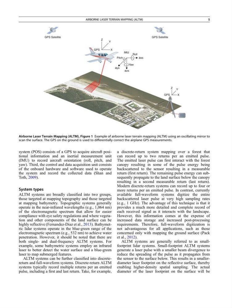
system (POS) consists of a GPS to acquire aircraft positional information and an inertial measurement unit
(IMU) to record aircraft orientation (roll, pitch, and
yaw). Third, the control and data acquisition unit consists
of the onboard hardware and software used to operate
the system and record the collected data (Shan and
Toth, 2009).
System types
ALTM systems are broadly classified into two groups,
those targeted at mapping topography and those targeted
at mapping bathymetry. Topographic systems generally
operate in the near-infrared wavelengths (e.g., 1,064 nm)
of the electromagnetic spectrum that allow for easier
compliance with eye safety regulations and where vegetation and other components of the land surface can be
highly reflective (Fernandez-Diaz et al., 2013). Bathymetric lidar systems operate in the blue-green range of the
electromagnetic spectrum (e.g., 532 nm) to achieve water
penetration. However, it should be noted that there are
both single- and dual-frequency ALTM systems. For
example, some bathymetric systems employ an infrared
laser to better detect the water surface and a blue-green
laser to map submerged features.
ALTM systems can be further classified into discretereturn and full-waveform systems. Discrete-return ALTM
systems typically record multiple returns per an emitted
pulse, including a first and last return. Take, for example,
a discrete-return system mapping over a forest that
can record up to two returns per an emitted pulse.
The emitted laser pulse can first interact with the forest
canopy resulting in some of the pulse energy being
backscattered to the sensor resulting in a measurable
return (first return). The remaining pulse energy can subsequently propagate to the land surface below the canopy
resulting in a second measurable return (last return).
Modern discrete-return systems can record up to four or
more returns per an emitted pulse. In contrast, currently
available full-waveform systems digitize the entire
backscattered laser pulse at very high sampling rates
(e.g., 1 GHz). The advantage of this technique is that it
provides a much more detailed and complete record of
each received signal as it interacts with the landscape.
However, this information comes at the expense of
increased data storage and increased post-processing
requirements. Therefore, full-waveform digitization is
not advantageous for all applications, such as those
concerned only with mapping the ground surface (Pack
et al., 2012).
ALTM systems are generally referred to as smallfootprint lidar systems. Small-footprint ALTM systems
generate a laser pulse with a smaller beam divergence to
reduce the spreading of the pulse as it propagates from
the sensor to the surface below. This results in a smallerdiameter laser footprint on the reflective surface, thereby
enabling higher-density spatial sampling. The actual
diameter of the laser footprint on the surface will be
IMU Roll
axs
Yaw
azs
ays
Pitch
Z
Y
X
X
GPS
Z Y
GPS
GPS Satellite
GPS Satellite
Airborne Laser Terrain Mapping (ALTM), Figure 1 Example of airborne laser terrain mapping (ALTM) using an oscillating mirror to
scan the surface. The GPS on the ground is used to differentially correct the airplane GPS measurements.
AIRBORNE LASER TERRAIN MAPPING (ALTM)
5
(IMU) to record aircraft orientation (roll, pitch, and
yaw). Third, the control and data acquisition unit consists
of the onboard hardware and software used to operate
the system and record the collected data (Shan and
Toth, 2009).
System types
ALTM systems are broadly classified into two groups,
those targeted at mapping topography and those targeted
at mapping bathymetry. Topographic systems generally
operate in the near-infrared wavelengths (e.g., 1,064 nm)
of the electromagnetic spectrum that allow for easier
compliance with eye safety regulations and where vegetation and other components of the land surface can be
highly reflective (Fernandez-Diaz et al., 2013). Bathymetric lidar systems operate in the blue-green range of the
electromagnetic spectrum (e.g., 532 nm) to achieve water
penetration. However, it should be noted that there are
both single- and dual-frequency ALTM systems. For
example, some bathymetric systems employ an infrared
laser to better detect the water surface and a blue-green
laser to map submerged features.
ALTM systems can be further classified into discretereturn and full-waveform systems. Discrete-return ALTM
systems typically record multiple returns per an emitted
pulse, including a first and last return. Take, for example,
a discrete-return system mapping over a forest that
can record up to two returns per an emitted pulse.
The emitted laser pulse can first interact with the forest
canopy resulting in some of the pulse energy being
backscattered to the sensor resulting in a measurable
return (first return). The remaining pulse energy can subsequently propagate to the land surface below the canopy
resulting in a second measurable return (last return).
Modern discrete-return systems can record up to four or
more returns per an emitted pulse. In contrast, currently
available full-waveform systems digitize the entire
backscattered laser pulse at very high sampling rates
(e.g., 1 GHz). The advantage of this technique is that it
provides a much more detailed and complete record of
each received signal as it interacts with the landscape.
However, this information comes at the expense of
increased data storage and increased post-processing
requirements. Therefore, full-waveform digitization is
not advantageous for all applications, such as those
concerned only with mapping the ground surface (Pack
et al., 2012).
ALTM systems are generally referred to as smallfootprint lidar systems. Small-footprint ALTM systems
generate a laser pulse with a smaller beam divergence to
reduce the spreading of the pulse as it propagates from
the sensor to the surface below. This results in a smallerdiameter laser footprint on the reflective surface, thereby
enabling higher-density spatial sampling. The actual
diameter of the laser footprint on the surface will be
IMU Roll
axs
Yaw
azs
ays
Pitch
Z
Y
X
X
GPS
Z Y
GPS
GPS Satellite
GPS Satellite
Airborne Laser Terrain Mapping (ALTM), Figure 1 Example of airborne laser terrain mapping (ALTM) using an oscillating mirror to
scan the surface. The GPS on the ground is used to differentially correct the airplane GPS measurements.
AIRBORNE LASER TERRAIN MAPPING (ALTM)
5