

been built up beyond the level of the high tide to levels of
high floodwaters by accretion of sediment from riverflood events. In the latter situation, they are subject to
prevailing floodwaters that also can erosionally plane
the delta surface. Nearly all landforms within a delta are
wet by one or more of the processes listed above. As
such, the majority of landforms within the delta are “wetlands,” but rather than viewing the delta as a single wetland, the delta actually is an integrated wetland complex
composed of a mosaic of wetland types. Each of the wetlands within this delta complex may have been developed
by different sedimentologic/geomorphic processes (e.g.,
a shoaled tidal flat vs. a vertically accreted floodplain or
a lagoon behind a deltaic wave-built barrier/bar
acting as a lake vs. a water-filled abandoned distributary
channel or water-filled abandoned meander), and each
wetland type may be maintained by one or more of the
hydrologic mechanisms of maintenance listed above.
Each of the delta types, whether fluvial, wave, or tide
dominated, tends to have their own characteristic
suite of wetlands (Figure 4). Examples of deltas with
various wetlands therein are illustrated in Figure 5. Sedimentary and vegetation descriptors have been added to
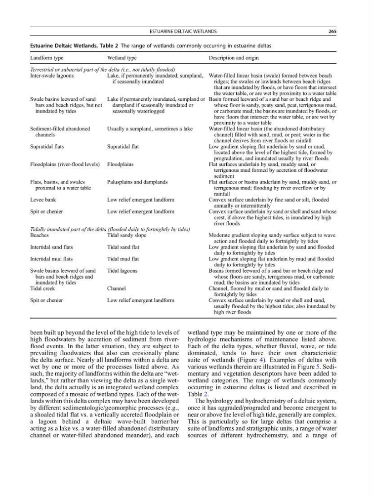
wetland categories. The range of wetlands commonly
occurring in estuarine deltas is listed and described in
Table 2.
The hydrology and hydrochemistry of a deltaic system,
once it has aggraded/prograded and become emergent to
near or above the level of high tide, generally are complex.
This is particularly so for large deltas that comprise a
suite of landforms and stratigraphic units, a range of water
sources of different hydrochemistry, and a range of
Estuarine Deltaic Wetlands, Table 2 The range of wetlands commonly occurring in estuarine deltas
Landform type
Wetland type
Description and origin
Terrestrial or subaerial part of the delta (i.e., not tidally flooded)
Inter-swale lagoons
Lake, if permanently inundated; sumpland,
if seasonally inundated
Water-filled linear basin (swale) formed between beach
ridges; the swales or lowlands between beach ridges
that are inundated by floods, or have floors that intersect
the water table, or are wet by proximity to a water table
Swale basins leeward of sand
bars and beach ridges, but not
inundated by tides
Lake if permanently inundated, sumpland or
dampland if seasonally inundated or
seasonally waterlogged
Basin formed leeward of a sand bar or beach ridge and
whose floor is sandy, peaty sand, peat, terrigenous mud,
or carbonate mud; the basins are inundated by floods, or
have floors that intersect the water table, or are wet by
proximity to a water table
Sediment-filled abandoned
channels
Usually a sumpland, sometimes a lake
Water-filled linear basin (the abandoned distributary
channel) filled with sand, mud, or peat; water in the
channel derives from river floods or rainfall
Supratidal flats
Supratidal flat
Low gradient sloping flat underlain by sand or mud,
located above the level of the highest tide, formed by
progradation, and inundated usually by river floods
Floodplains (river-flood levels) Floodplains
Flat surfaces underlain by sand, muddy sand, or
terrigenous mud formed by accretion of floodwater
sediment
Flats, basins, and swales
proximal to a water table
Palusplains and damplands
Flat surfaces or basins underlain by sand, muddy sand, or
terrigenous mud; flooding by river overflow or by
rainfall
Levee bank
Low relief emergent landform
Convex surface underlain by fine sand or silt, flooded
annually or intermittently
Spit or chenier
Low relief emergent landform
Convex surface underlain by sand or shell and sand whose
crest, if above the highest tides, is inundated by high
river floods
Tidally inundated part of the delta (flooded daily to fortnightly by tides)
Beaches
Tidal sandy slope
Moderate gradient sloping sandy surface subject to wave
action and flooded daily to fortnightly by tides
Intertidal sand flats
Tidal sand flat
Low gradient sloping flat underlain by sand and flooded
daily to fortnightly by tides
Intertidal mud flats
Tidal mud flat
Low gradient sloping flat underlain by mud and flooded
daily to fortnightly by tides
Swale basins leeward of sand
bars and beach ridges and
inundated by tides
Tidal lagoons
Basins formed leeward of a sand bar or beach ridge and
whose floors are sandy, terrigenous mud, or carbonate
mud; the basins are inundated by tides
Tidal creek
Channel
Channel, floored by mud or sand and flooded daily to
fortnightly by tides
Spit or chenier
Low relief emergent landform
Convex surface underlain by sand or shell and sand,
usually flooded by the highest tides; also inundated by
high river floods
ESTUARINE DELTAIC WETLANDS
265
high floodwaters by accretion of sediment from riverflood events. In the latter situation, they are subject to
prevailing floodwaters that also can erosionally plane
the delta surface. Nearly all landforms within a delta are
wet by one or more of the processes listed above. As
such, the majority of landforms within the delta are “wetlands,” but rather than viewing the delta as a single wetland, the delta actually is an integrated wetland complex
composed of a mosaic of wetland types. Each of the wetlands within this delta complex may have been developed
by different sedimentologic/geomorphic processes (e.g.,
a shoaled tidal flat vs. a vertically accreted floodplain or
a lagoon behind a deltaic wave-built barrier/bar
acting as a lake vs. a water-filled abandoned distributary
channel or water-filled abandoned meander), and each
wetland type may be maintained by one or more of the
hydrologic mechanisms of maintenance listed above.
Each of the delta types, whether fluvial, wave, or tide
dominated, tends to have their own characteristic
suite of wetlands (Figure 4). Examples of deltas with
various wetlands therein are illustrated in Figure 5. Sedimentary and vegetation descriptors have been added to
wetland categories. The range of wetlands commonly
occurring in estuarine deltas is listed and described in
Table 2.
The hydrology and hydrochemistry of a deltaic system,
once it has aggraded/prograded and become emergent to
near or above the level of high tide, generally are complex.
This is particularly so for large deltas that comprise a
suite of landforms and stratigraphic units, a range of water
sources of different hydrochemistry, and a range of
Estuarine Deltaic Wetlands, Table 2 The range of wetlands commonly occurring in estuarine deltas
Landform type
Wetland type
Description and origin
Terrestrial or subaerial part of the delta (i.e., not tidally flooded)
Inter-swale lagoons
Lake, if permanently inundated; sumpland,
if seasonally inundated
Water-filled linear basin (swale) formed between beach
ridges; the swales or lowlands between beach ridges
that are inundated by floods, or have floors that intersect
the water table, or are wet by proximity to a water table
Swale basins leeward of sand
bars and beach ridges, but not
inundated by tides
Lake if permanently inundated, sumpland or
dampland if seasonally inundated or
seasonally waterlogged
Basin formed leeward of a sand bar or beach ridge and
whose floor is sandy, peaty sand, peat, terrigenous mud,
or carbonate mud; the basins are inundated by floods, or
have floors that intersect the water table, or are wet by
proximity to a water table
Sediment-filled abandoned
channels
Usually a sumpland, sometimes a lake
Water-filled linear basin (the abandoned distributary
channel) filled with sand, mud, or peat; water in the
channel derives from river floods or rainfall
Supratidal flats
Supratidal flat
Low gradient sloping flat underlain by sand or mud,
located above the level of the highest tide, formed by
progradation, and inundated usually by river floods
Floodplains (river-flood levels) Floodplains
Flat surfaces underlain by sand, muddy sand, or
terrigenous mud formed by accretion of floodwater
sediment
Flats, basins, and swales
proximal to a water table
Palusplains and damplands
Flat surfaces or basins underlain by sand, muddy sand, or
terrigenous mud; flooding by river overflow or by
rainfall
Levee bank
Low relief emergent landform
Convex surface underlain by fine sand or silt, flooded
annually or intermittently
Spit or chenier
Low relief emergent landform
Convex surface underlain by sand or shell and sand whose
crest, if above the highest tides, is inundated by high
river floods
Tidally inundated part of the delta (flooded daily to fortnightly by tides)
Beaches
Tidal sandy slope
Moderate gradient sloping sandy surface subject to wave
action and flooded daily to fortnightly by tides
Intertidal sand flats
Tidal sand flat
Low gradient sloping flat underlain by sand and flooded
daily to fortnightly by tides
Intertidal mud flats
Tidal mud flat
Low gradient sloping flat underlain by mud and flooded
daily to fortnightly by tides
Swale basins leeward of sand
bars and beach ridges and
inundated by tides
Tidal lagoons
Basins formed leeward of a sand bar or beach ridge and
whose floors are sandy, terrigenous mud, or carbonate
mud; the basins are inundated by tides
Tidal creek
Channel
Channel, floored by mud or sand and flooded daily to
fortnightly by tides
Spit or chenier
Low relief emergent landform
Convex surface underlain by sand or shell and sand,
usually flooded by the highest tides; also inundated by
high river floods
ESTUARINE DELTAIC WETLANDS
265