

parts of the delta that are distant enough from the estuarine
aquatic environment such that they are not wet by the tides
and waves of the estuarine aquatic environment), the
wetting process(es) may be solely one or a combination
of the following: (1) rain (where the rainwater is ponded
and perched or waterlogs the surface materials to form
the wetland); (2) water table rise and fall in response to
tide fluctuation, or to seasonal rain, or to seasonal regional
throughflow; (3) the effect of a shallow water table
resulting in wetting of surface sediments/soils by capillary
rise; (4) over-bank flow from the distributary channels;
and (5) run-in where surface flows collect into a basin or
a water-retaining landform such as a floodplain. For
wetlands on the tidally inundated part of the delta
that form the “tidal coast” fronting the estuarine aquatic
environment and are subject to wetting by coastal
processes of tides and waves, the wetting process
(es) may be one of the following: (1) daily wetting of tidal
flats by tides, (2) the daily flooding and draining of tidal
creeks by the tide, (3) wave swash and run-up, and
(4) storm surges and atmospheric depression-induced
high-water stands causing flooding of lowlands by incursion of estuarine water or marine water. As such, all terrain
built by fluvial processes to levels above the high tide that
are wet by fluvial and meteoric processes are terrestrial
wetlands, and all surfaces that are daily flooded and
exposed by tides or wet by wave action and storm surges
are the tidally inundated wetlands on the delta. It should
be noted that all deltaic surfaces that are permanently
subtidal are not considered to be wetlands sensu Semeniuk
and Semeniuk (1995, 2011).
Depending on the wetting agent – rain, river water,
estuarine water, or marine water – and on the frequency
of the wetting process, the groundwater and/or
surface water of the wetland may be freshwater,
brackish, or saline, and it may be stasohaline (remaining
relatively constant throughout the year) or poikilohaline
(e.g., alternating between salinity fields, such as between
freshwater and saline water).
Individual wetlands can be classified according to their
geomorphic and hydrologic characteristics, following
Semeniuk and Semeniuk (1995, 2011) for nonmarine wetlands and Semeniuk (1986) for coastal tidally influenced
wetlands. The wetland classification of Semeniuk
and Semeniuk (1995, 2011), termed the “geomorphichydrologic classification,” recognizes the various types
of landforms that comprise wetlands and the hydrologic
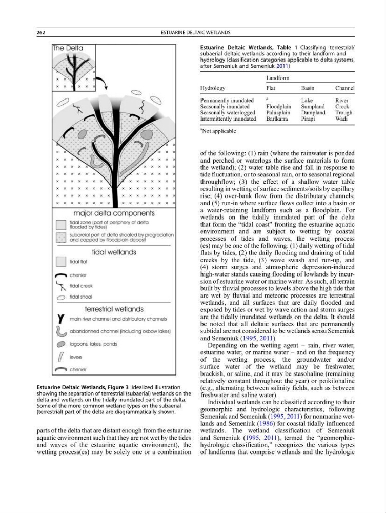
Estuarine Deltaic Wetlands, Figure 3 Idealized illustration
showing the separation of terrestrial (subaerial) wetlands on the
delta and wetlands on the tidally inundated part of the delta.
Some of the more common wetland types on the subaerial
(terrestrial) part of the delta are diagrammatically shown.
Estuarine Deltaic Wetlands, Table 1 Classifying terrestrial/
subaerial deltaic wetlands according to their landform and
hydrology (classification categories applicable to delta systems,
after Semeniuk and Semeniuk 2011)
Landform
Hydrology
Flat
Basin
Channel
Permanently inundated
a
Lake
River
Seasonally inundated
Floodplain
Sumpland
Creek
Seasonally waterlogged
Palusplain
Dampland
Trough
Intermittently inundated
Barlkarra
Pirapi
Wadi
a Not applicable
262
ESTUARINE DELTAIC WETLANDS
aquatic environment such that they are not wet by the tides
and waves of the estuarine aquatic environment), the
wetting process(es) may be solely one or a combination
of the following: (1) rain (where the rainwater is ponded
and perched or waterlogs the surface materials to form
the wetland); (2) water table rise and fall in response to
tide fluctuation, or to seasonal rain, or to seasonal regional
throughflow; (3) the effect of a shallow water table
resulting in wetting of surface sediments/soils by capillary
rise; (4) over-bank flow from the distributary channels;
and (5) run-in where surface flows collect into a basin or
a water-retaining landform such as a floodplain. For
wetlands on the tidally inundated part of the delta
that form the “tidal coast” fronting the estuarine aquatic
environment and are subject to wetting by coastal
processes of tides and waves, the wetting process
(es) may be one of the following: (1) daily wetting of tidal
flats by tides, (2) the daily flooding and draining of tidal
creeks by the tide, (3) wave swash and run-up, and
(4) storm surges and atmospheric depression-induced
high-water stands causing flooding of lowlands by incursion of estuarine water or marine water. As such, all terrain
built by fluvial processes to levels above the high tide that
are wet by fluvial and meteoric processes are terrestrial
wetlands, and all surfaces that are daily flooded and
exposed by tides or wet by wave action and storm surges
are the tidally inundated wetlands on the delta. It should
be noted that all deltaic surfaces that are permanently
subtidal are not considered to be wetlands sensu Semeniuk
and Semeniuk (1995, 2011).
Depending on the wetting agent – rain, river water,
estuarine water, or marine water – and on the frequency
of the wetting process, the groundwater and/or
surface water of the wetland may be freshwater,
brackish, or saline, and it may be stasohaline (remaining
relatively constant throughout the year) or poikilohaline
(e.g., alternating between salinity fields, such as between
freshwater and saline water).
Individual wetlands can be classified according to their
geomorphic and hydrologic characteristics, following
Semeniuk and Semeniuk (1995, 2011) for nonmarine wetlands and Semeniuk (1986) for coastal tidally influenced
wetlands. The wetland classification of Semeniuk
and Semeniuk (1995, 2011), termed the “geomorphichydrologic classification,” recognizes the various types
of landforms that comprise wetlands and the hydrologic
Estuarine Deltaic Wetlands, Figure 3 Idealized illustration
showing the separation of terrestrial (subaerial) wetlands on the
delta and wetlands on the tidally inundated part of the delta.
Some of the more common wetland types on the subaerial
(terrestrial) part of the delta are diagrammatically shown.
Estuarine Deltaic Wetlands, Table 1 Classifying terrestrial/
subaerial deltaic wetlands according to their landform and
hydrology (classification categories applicable to delta systems,
after Semeniuk and Semeniuk 2011)
Landform
Hydrology
Flat
Basin
Channel
Permanently inundated
a
Lake
River
Seasonally inundated
Floodplain
Sumpland
Creek
Seasonally waterlogged
Palusplain
Dampland
Trough
Intermittently inundated
Barlkarra
Pirapi
Wadi
a Not applicable
262
ESTUARINE DELTAIC WETLANDS