

geological heritage through the integrated and sustainable
development of their territories. Similarly, an estuary can
qualify also for this designation. The Asia Pacific
Geoparks Network, founded in 2007, defines geoparks
as nationally protected areas containing a number of geological heritage sites of particular importance, rarity or
aesthetic appeal. These earth heritage sites are part of an
integrated concept of protection, education, and sustainable development. An estuary can qualify also for this designation. All these initiatives aim to protect geodiversity,
promote geological heritage, and support local sustainable
economic development, thus involving community and
commercial interests.
Estuaries lend themselves to designation as geoparks
because they inherently have multiple uses (fishing,
boating, shoreline nature walks, areas of conservation for
waterbirds) and often illustrate interrelated features of
landscape, geology, estuarine geomorphology, and sedimentology that can be utilized for science and education
and tourism. Brocx and Semeniuk (2009) identified the
Walpole-Nornalup Inlet Estuary in Western Australia as
an integrated geopark, wherein the various Cenozoic and
Holocene geological and estuarine features could be used
as features for nature tours. Thus, estuaries can be viewed
as potential geoparks, i.e., conservation, and promotional
entities focused on geological and geomorphological attributes for local sustainable development.
The leschenault inlet estuary and
walpole-nornalup inlet estuary: case studies
The Leschenault Inlet Estuary and Walpole-Nornalup Inlet
Estuary provide examples of the application of the
geoheritage tool kit to identify and assess features of
geoheritage significance in the estuaries. Both present two
extremes of types in Western Australia. The Leschenault
Inlet Estuary, a barrier dune barred estuarine lagoon, with
two contributing rivers at its southern end, is located in
a subhumid part of Western Australia, facing the swelldominated Indian Ocean (Brocx and Semeniuk, 2011).
Brocx and Semeniuk (2011) identify 10 features of
geoheritage significance in the estuary. Of these, one feature
is assessed as internationally significant, two as nationally
significant, and seven as being of statewide or regionally
significant (Figure 5). Brocx and Semeniuk (2011) proffer
that the estuarine system, with its geological framework,
complex shores, estuarine geomorphology and stratigraphy,
and multitude of important small-scale features, also could
function as geopark for geotours, research, and education.
The Walpole-Nornalup Inlet Estuary, a twin ria estuary
with a dune barrier and three contributing rivers, is located
in the most humid part of Western Australia, facing the
high-energy Southern Ocean (Semeniuk et al., 2011).
Semeniuk et al. (2011) identify 22 features of geoheritage
significance that include its intra-estuarine delta and peatfloored peripheral wetlands. Of these, one feature is
assessed as internationally significant, two as nationally
significant, and 19 as statewide or regionally significant
(Figure 6). Semeniuk et al. (2011) proffer that the estuarine system of Walpole-Nornalup Inlet, with its geological
framework, estuarine geomorphology and stratigraphy,
and multitude of important small-scale features, could
function as geopark for geotours, research, and education.
Summary
In estuaries, to date, there has been emphasis on their
biological significance, e.g., their vegetation complexes,
productivity, invertebrate fauna, and fisheries, and hence
their conservation and management from a biological perspective, and less on the importance of their geology, geomorphology, sedimentology, hydrology, and geohistorical
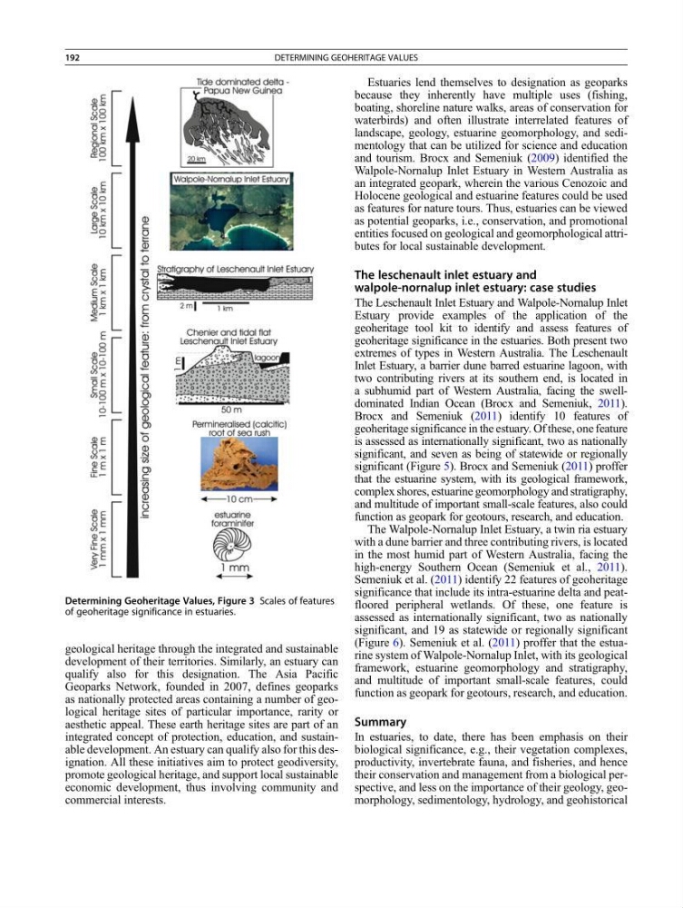
Determining Geoheritage Values, Figure 3 Scales of features
of geoheritage significance in estuaries.
192
DETERMINING GEOHERITAGE VALUES
development of their territories. Similarly, an estuary can
qualify also for this designation. The Asia Pacific
Geoparks Network, founded in 2007, defines geoparks
as nationally protected areas containing a number of geological heritage sites of particular importance, rarity or
aesthetic appeal. These earth heritage sites are part of an
integrated concept of protection, education, and sustainable development. An estuary can qualify also for this designation. All these initiatives aim to protect geodiversity,
promote geological heritage, and support local sustainable
economic development, thus involving community and
commercial interests.
Estuaries lend themselves to designation as geoparks
because they inherently have multiple uses (fishing,
boating, shoreline nature walks, areas of conservation for
waterbirds) and often illustrate interrelated features of
landscape, geology, estuarine geomorphology, and sedimentology that can be utilized for science and education
and tourism. Brocx and Semeniuk (2009) identified the
Walpole-Nornalup Inlet Estuary in Western Australia as
an integrated geopark, wherein the various Cenozoic and
Holocene geological and estuarine features could be used
as features for nature tours. Thus, estuaries can be viewed
as potential geoparks, i.e., conservation, and promotional
entities focused on geological and geomorphological attributes for local sustainable development.
The leschenault inlet estuary and
walpole-nornalup inlet estuary: case studies
The Leschenault Inlet Estuary and Walpole-Nornalup Inlet
Estuary provide examples of the application of the
geoheritage tool kit to identify and assess features of
geoheritage significance in the estuaries. Both present two
extremes of types in Western Australia. The Leschenault
Inlet Estuary, a barrier dune barred estuarine lagoon, with
two contributing rivers at its southern end, is located in
a subhumid part of Western Australia, facing the swelldominated Indian Ocean (Brocx and Semeniuk, 2011).
Brocx and Semeniuk (2011) identify 10 features of
geoheritage significance in the estuary. Of these, one feature
is assessed as internationally significant, two as nationally
significant, and seven as being of statewide or regionally
significant (Figure 5). Brocx and Semeniuk (2011) proffer
that the estuarine system, with its geological framework,
complex shores, estuarine geomorphology and stratigraphy,
and multitude of important small-scale features, also could
function as geopark for geotours, research, and education.
The Walpole-Nornalup Inlet Estuary, a twin ria estuary
with a dune barrier and three contributing rivers, is located
in the most humid part of Western Australia, facing the
high-energy Southern Ocean (Semeniuk et al., 2011).
Semeniuk et al. (2011) identify 22 features of geoheritage
significance that include its intra-estuarine delta and peatfloored peripheral wetlands. Of these, one feature is
assessed as internationally significant, two as nationally
significant, and 19 as statewide or regionally significant
(Figure 6). Semeniuk et al. (2011) proffer that the estuarine system of Walpole-Nornalup Inlet, with its geological
framework, estuarine geomorphology and stratigraphy,
and multitude of important small-scale features, could
function as geopark for geotours, research, and education.
Summary
In estuaries, to date, there has been emphasis on their
biological significance, e.g., their vegetation complexes,
productivity, invertebrate fauna, and fisheries, and hence
their conservation and management from a biological perspective, and less on the importance of their geology, geomorphology, sedimentology, hydrology, and geohistorical
Determining Geoheritage Values, Figure 3 Scales of features
of geoheritage significance in estuaries.
192
DETERMINING GEOHERITAGE VALUES