

used in dealing with sites of geoheritage significance
are regional, large, medium, small, fine, and very fine
scales (Figure 3). Scale is important to consider in
geoheritage/geoconservation since features of significance can range from crystals, bedding planes, and outcrops to that of landscapes and mountains. In many
locations, sites are important because of crystal-sized
phenomena and crystal fabrics (e.g., dolomite or
permineralization in estuarine shorelines) or because
of outcrops and bedding scale features (such as elevated
estuarine fossil deposits). In the case of estuaries, the
largest scale involves the size of the estuarine embayment, which may be tens of kilometers in size, and
can involve the lower reaches of the drainage basin.
Step 5 assesses the level of geoheritage significance of the
geological features regardless of their scale (Figure 4).
The level of importance attributed to a given feature
of geoheritage significance is related to how frequent
or common is the feature within a scale of reference
and/or how important is the feature to a given culture.
Levels of significance are (Brocx and Semeniuk,
2007) (1) international, (2) national, (3) statewide to
regional, and (4) local. Levels of significance of
geoheritage features of (and within) estuaries are illustrated in Figure 4.
After an assessment of the range, categories, interrelationships, and level(s) of significance of the geological
features, the final step is Step 6 which will determine what
type and what level of geoconservation are assigned to the
estuary whether in toto or in part.
Large estuaries, or sites within estuaries that are of
geoheritage significance, or an amalgamation of numerous smaller sites of geoheritage significance can be
assigned to geopark status. The Global Geoparks initiative
supported by UNESCO sees geoparks as a territory
encompassing one or more sites of scientific importance,
not only for geological reasons but also by virtue of its
archaeological, ecological, or cultural value. An estuary
thus can qualify for this designation. The European
Geoparks Network, established in 2000 (Zouros, 2000),
defines a geopark as an area to conserve and valorize
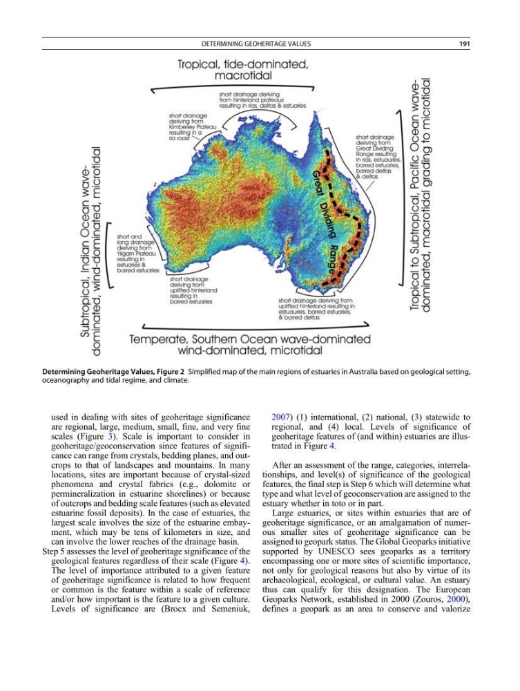
Determining Geoheritage Values, Figure 2 Simplified map of the main regions of estuaries in Australia based on geological setting,
oceanography and tidal regime, and climate.
DETERMINING GEOHERITAGE VALUES
191
are regional, large, medium, small, fine, and very fine
scales (Figure 3). Scale is important to consider in
geoheritage/geoconservation since features of significance can range from crystals, bedding planes, and outcrops to that of landscapes and mountains. In many
locations, sites are important because of crystal-sized
phenomena and crystal fabrics (e.g., dolomite or
permineralization in estuarine shorelines) or because
of outcrops and bedding scale features (such as elevated
estuarine fossil deposits). In the case of estuaries, the
largest scale involves the size of the estuarine embayment, which may be tens of kilometers in size, and
can involve the lower reaches of the drainage basin.
Step 5 assesses the level of geoheritage significance of the
geological features regardless of their scale (Figure 4).
The level of importance attributed to a given feature
of geoheritage significance is related to how frequent
or common is the feature within a scale of reference
and/or how important is the feature to a given culture.
Levels of significance are (Brocx and Semeniuk,
2007) (1) international, (2) national, (3) statewide to
regional, and (4) local. Levels of significance of
geoheritage features of (and within) estuaries are illustrated in Figure 4.
After an assessment of the range, categories, interrelationships, and level(s) of significance of the geological
features, the final step is Step 6 which will determine what
type and what level of geoconservation are assigned to the
estuary whether in toto or in part.
Large estuaries, or sites within estuaries that are of
geoheritage significance, or an amalgamation of numerous smaller sites of geoheritage significance can be
assigned to geopark status. The Global Geoparks initiative
supported by UNESCO sees geoparks as a territory
encompassing one or more sites of scientific importance,
not only for geological reasons but also by virtue of its
archaeological, ecological, or cultural value. An estuary
thus can qualify for this designation. The European
Geoparks Network, established in 2000 (Zouros, 2000),
defines a geopark as an area to conserve and valorize
Determining Geoheritage Values, Figure 2 Simplified map of the main regions of estuaries in Australia based on geological setting,
oceanography and tidal regime, and climate.
DETERMINING GEOHERITAGE VALUES
191